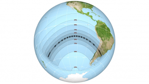
On July 2, a solar eclipse swept across the South Pacific and southern South America.
In parts of Chile and Argentina, skywatchers witnessed a total eclipse of the sun, in which the moon blocked the sun from view — with the exception of its wispy corona. In other parts of South America, skywatchers saw a partial eclipse, with the moon taking a “bite” out of the sun’s face.
With this photo guide, you can find out exactly where the eclipse was visible and what it looked like. (Viewing guides are at the top; to see photos of the actual eclipse, scroll down a bit.)

This map represents the path that the moon’s shadow will take across the Earth’s surface during the total solar eclipse. Outside the path of totality, this map shows the percentage of the sun’s disk that will be covered by the moon at maximum partial eclipse.
Read more HERE
Ask me anything
Explore related questions


