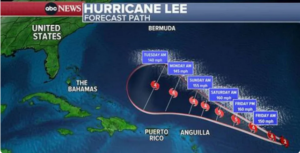
Hurricane Lee, now churning over the Atlantic Ocean, intensified very rapidly on Thursday, strengthening from a Category 2 hurricane to a Category 4 hurricane.
Lee is forecast to become a Category 5 hurricane with winds of 160 mph by Thursday night.
Lee is expected to move north of the Caribbean islands over the weekend, sparing them any direct impacts other than rough surf and rip currents.
By next week, the spaghetti models show the storm turning north before reaching Turks and Caicos. Bermuda may be in Lee’s path.
Long-range models can change over the next week, but they currently show Lee moving parallel to the eastern United States coastline. If Lee stays on that course, the East Coast would be hit with large surf and rip currents by late next week.
Secret Memo raises more questions about UFO shootdowns over Alaska, Canada
It is too early to predict whether Lee will impact the U.S., but some models show the storm hitting the Maine/Canada border around Sept. 16. By that time, Lee will be weaker, and likely won’t be a major hurricane.
The Federal Emergency Management Agency has pre-deployed assets to Puerto Rico and the Virgin Islands, according to the White House.
President Joe Biden was briefed Thursday on the latest trajectory and FEMA’s preparations, the White House said.
Source: yahoo
Ask me anything
Explore related questions


