
Record-breaking temperatures in the first ten days of June among the stations of the meteo.gr/National Observatory of Athens network of automatic weather stations.
After yesterday’s recording of 39.3 °C in Elefsina and Thebes (Nea Odos), today the thermometer exceeded 40 degrees in areas of Crete and Rhodes: in Gortyna Heraklion it reached 41.5 degrees, in Plora Heraklion 41.3 degrees and in Lindos 40.4 degrees.
As shown in the following table, Crete and Messinia have the honorary title in terms of heat. Thus, after Lindos, Petrokefali of Mires follows with 39.9 degrees, Skala of Messinia with 39.6 degrees, Stavias of Heraklion and Vagionia of Heraklion with 39.4 degrees and Siva of Heraklion with 39.3 degrees.
After the heat, windy weather comes at the weekend and a new round of high temperatures follows
The course of the weather in the coming days was analysed in posts on Twitter and Facebook by Theo Kolydas and Klearchos Marousakis.
Kolydas speaks of a temporary drop in temperature from Thursday, followed by a new wave of rising temperatures on Sunday.
For his part, Klearchos Marousakis stresses that after the heat wave yesterday and today, instability and winds will follow, which in turn will be followed by high temperatures like those we are experiencing today from next Monday.
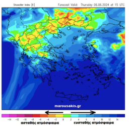
The Marousakis post: From heat to instability and then to meteors:
? ΠΡΟΣΚΑΙΡΗ Η ΠΤΩΣΗ ΤΗΣ ΘΕΡΜΟΚΡΑΣΙΑΣ- ΕΡΧΕΤΑΙ NEO KYMA ΖΕΣΤΗΣ ΑΠΟ ΒΔΟΜΑΔΑ.
✅H πτώση της θερμοκρασίας από την Πέμπτη θα είναι βραχεία , καθώς θα ακολουθήσει νέο κύμα ανόδου από την Κυριακή. Το νέο κύμα ζέστης θα κρατήσει τουλάχιστον έως και τα μέσα της ερχόμενης εβδομάδος.… pic.twitter.com/n5Kol8zLXt— Theodoros Kolydas (@KolydasT) June 5, 2024
With enough heat for the season we are the last few days in our country with the mercury to approach in several areas of 34 ° to 36 ° degrees and very locally encountered temperatures even above 38 ° Celsius.
And today will be a fairly warm day while over the weekend Thursday and Friday a colder air mass high in the atmosphere comes to combine with the very warm surface and give strong atmospheric instability.
Our first map notes the cooler air mass at about 5.5 km above the surface, while our second map shows the instability that will affect many continental areas over the Thursday and Friday weekend.
What unstable atmosphere means:
As discussed above colder air is expected to affect the upper layers of the atmosphere in the coming days. However, as we already have quite high temperatures down low, this temperature contrast will lead to strong upward air movements towards the formation of storm clouds as long as the humidity is also at sufficient levels.
So where the greatest temperature differences will be observed, and these are of course found in the late afternoon, there will be periods of time when showers, thunderstorms and even hail will develop.
Why hailstorms are favoured
The very warm air is expelled with great intensity upwards, entrapping and at the same time condensing the water vapour it carries. This forms storm clouds that can reach great heights at their tops, so that the hydrocarbons are transformed into ice crystals that constantly increase in size as they collide with other hydrocarbons or ice crystals (imagine onion skins).
So when they reach a size where gravity beats the updraft they will fall downwards in the form of quartz grains.
UK: Banknotes featuring King Charles have been released
The weekend
Into the weekend, volatility is expected to be reduced again especially in mountainous areas and as these cold air masses high in the atmosphere move towards Turkey they will enhance the pressure differential down low and thus the melts or better yet, the paiseas towards the Aegean side.
Our third map illustrates the mechanism for creating the pacifics with the low pressures towards Cyprus and the higher pressures further north.
New heat wave from Monday
From Monday, the winds will slowly start to reduce so the warm air will have the chance to flood our region again.
So from the 10th of the month until about the 14th we are likely to experience a similar heat wave to these days.
As you can see in our last chart there is a lot of uncertainty for the rest of the month, so it is best to close our ears to announcements of the type “40s or 45s coming” from the middle of the month etc.
Ask me anything
Explore related questions