The heatwave continues its onslaught, even more intense now, as the Emergency Weather Bulletin issued by the Hellenic National Meteorological Service (EMY) and meteorologists indicates that the unusually high temperatures will persist until July 22.
Temperatures are already rising, with forecasts predicting 42°C over the weekend. The peak of the heatwave is expected to start on Monday (July 15) and culminate on Wednesday (July 17), when temperatures could reach 43°C and 44°C in heat-sensitive areas, particularly in western Greece and the Peloponnese.
Kolydas: Peak on Wednesday
The movement of the hot air masses causing the heatwave in our country is expected to go through three phases, according to Theodoros Kolydas, director of the National Meteorological Service, in a post.
According to him, the first phase, which we are experiencing these days, brings strong meltemi winds in the east and heat in the west and north. The second phase is expected next Wednesday (July 17), when the heatwave will peak and spread to other areas of the country. The third phase is anticipated at the end of next week, when the heatwave will finally subside.
?️?️?️ 12-21 JULY 2024- THE THREE PHASES OF THE GAS MASS MOVEMENT
✅The reason for the prolonged duration of very high temperatures in our region is atmospheric circulation over Europe, with the depressions continuing to affect the Northwestern portions of… pic.twitter.com/2fA4sEwCG4– Theodoros Kolydas (@KolydasT) July 11, 2024</blockquote
Klearchos Marousakis, in his weather forecast, mentions prolonged heat but nothing extreme. In his post, the OPEN meteorologist, while sharing maps, states: “Much will be written and said in the coming days about the intense and especially prolonged heatwave. Statistically, July is the hottest month of the year. From there, the interpretation of a phenomenon is not far from misinterpretation. In short, regarding the situation… Yes, it will be quite hot. The highest temperatures locally, slightly above 40°C and possibly around 42°C, will be found in the west and north (see maps below per day).
From a synoptic circulation perspective, we cannot talk about an extensive heatwave (which doesn’t matter much to the public). The explanation is given in the first map, where within the circles, we highlight the temperatures that lead to heatwave conditions. These circles are very limited, and the reason is the blue arrow indicating the meltemi winds that disrupt this indeed heatwave-inducing air mass.
It is important (I emphasize once again) how we measure the temperature and where we measure it. Also, the number of stations we had 20 years ago versus what we have now and how the conclusions then compare with today. Basic elements we learn in our early university days and unfortunately quickly forget. Following are maps describing the phenomenon! Patience and calm! We’ve experienced worse!”
Also, as EMY points out, we will also see 43s next week in western Central Greece, Thessaly and western Peloponnese, while a peak in temperatures is predicted in the middle of next week.
meteo.gr, stresses that the prevalence of very high temperatures for the 5th consecutive day in our country, exceeding even 38-40 degrees Celsius in many areas, contributes to the maintenance of the heat burden and the relative danger to human health at high levels.
Watch live heatwave and how it’s moving:
A further increase in risk is expected today in northern and central parts of the mainland, reaching up to the extreme level of risk in regional units and areas of the East Coast. Macedonia and Thrace (Evros, Rodopi, Xanthi, Kavala, Thassos) and Central Macedonia (Serres, Kilkis, Lagadas-Volvi, Halkidiki, Pella, Imathia, Pieria), as shown below:
It is noted that the partial weakening of the wind intensity in the Aegean is expected to contribute to the increase of heat load even in eastern continental parts of the country, including Attica, with the relative risk estimated at a high level.
Finally, it should be emphasized that exposure to ambient radiation is a significant factor in increasing the heat burden and the associated risk to human health.
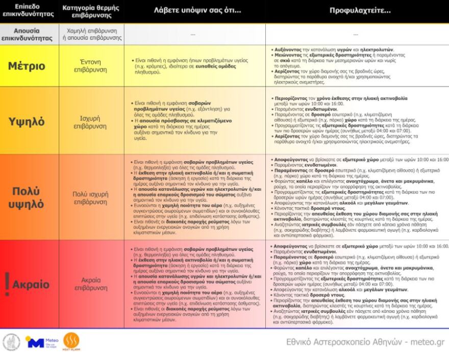
How to protect yourself from high temperatures
For this, it is strongly recommended to avoid outdoor activities during the day, and particularly between 10:00 and 16:00, combined with the implementation of additional protective measures, such as those detailed in the following figure.

The special weather bulletin from the National Weather Service
In its sixth weather bulletin, EMY said:
The southwest current prevailing in the lower levels of the atmosphere on the coast of Africa and the Central Mediterranean will carry warm air masses towards our region and will cause very high temperatures in our country, which will be maintained at least until Friday 19/7.
The highest temperatures will occur in the interior of mainland Greece (mainly in the west and north) and on the islands of the eastern Aegean.
In the coastal areas of the mainland the maximum temperature will be 2 to 4 degrees lower due to the sea breeze.
Minimum temperatures will also be high, especially from Monday 15/7.
More detailed:
1.On Saturday (13-7-2024) the maximum temperature will reach:
a. In Macedonia, Thrace and Epirus 37 to 39 degrees Celsius and in central Macedonia locally 40 to 41 degrees Celsius.
b. In Central Greece, Thessaly and the Peloponnese 38 to 40 degrees Celsius and locally 41 degrees Celsius.
c. In the Ionian Sea, the East Aegean islands, the Dodecanese and southern Crete 36 to 38 degrees Celsius.
d. In the rest of the island country 33 to 35 degrees Celsius.
e. 38 to 39 degrees Celsius in Attica.
2. On Sunday (14-7-2024)high temperatures will prevail mainly in the west, the north, the islands of the eastern Aegean and the Dodecanese. The maximum temperature will reach:
a. In Macedonia, Thrace and Epirus 38 to 40 degrees and
locally in central Macedonia 41 to 42 degrees Celsius.
b. In western Central Greece, Thessaly and western Peloponnese 40 to 42 degrees Celsius.
c. In eastern Sterea and eastern Peloponnese between 40 and
locally 41 degrees Celsius.
d. In the Ionian Sea, the East Aegean islands, the Dodecanese and southern Crete 37 to 39 degrees Celsius.
e. In the rest of the island country 34 to 36 degrees Celsius.
f. 39 to 40 degrees Celsius in Attica.
3. On Monday (15-7-2024) the maximum temperature will reach:
a. In Macedonia, Thrace and Epirus 39 to 40 degrees Celsius and in central Macedonia locally 41 to 42 degrees Celsius.
b. In western Sterea, Thessaly and western Peloponnese 41 to 42 and possibly locally 43 degrees Celsius.
c. In eastern Sterea and eastern Peloponnese 41 to 42 degrees Celsius.
d. In the Ionian Sea, the East Aegean islands, the Dodecanese and southern Crete 39 to 40 degrees Celsius.
e. In the rest of the island country 35 to 37 degrees Celsius.
f. 39 to 40 degrees Celsius in Attica.
4. In the middle of next week a peak of temperatures is forecasted.
High temperatures in the Attica basin even at night – Up to 32 °C in the centre of Athens
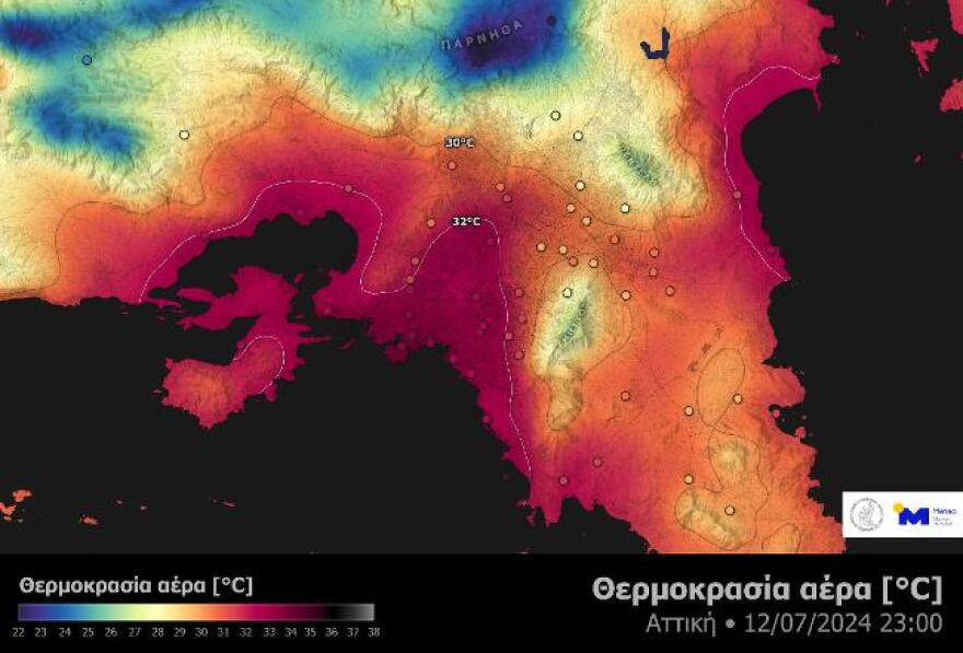
High temperatures were recorded even overnight in many parts of the country amid a heat wave. The situation is much worse in major urban centres with temperatures failing to drop even below 30°C.
The map below shows the air temperature as calculated from the recordings of the network of automatic meteorological stations of meteo.gr/National Observatory of Athens at 23:00 on Friday night 12/07 in the region of Attica. Most of the Attica basin and at the same time the population experienced temperatures even above 32°C during the night. This, is a significant factor in increasing the heat burden and the associated risk to human health especially for vulnerable groups of the population.

Figure 1. Air temperature on Friday 12/07 at 11 pm in the region of Attica, as recorded by the network of automatic meteorological stations of meteo.gr/Athens National Observatory.
The weather today
A few clouds are expected, which will increase locally during the warm hours of the day. Rain or thunderstorms will occur in mountainous areas mainly along Pindos and possibly locally in the northern part of the country. The heat burden will be increased in many areas of the country, with emphasis on urban centres.
The temperature will range in Western Macedonia from 18 to 36 degrees, in the rest of northern Greece from 22 to 37-39 and possibly locally 40 degrees, in Thessaly from 20 to 38-40 and locally 41-42, in Epirus from 22 to 37-39 degrees, in the rest of the mainland from 25 to 37-39 degrees and locally 40-41 degrees, in the Ionian Islands from 23 to 36-38 degrees, in the East Aegean islands from 24 to 36-38 degrees, in the rest of the Aegean islands and in Crete from 24 to 33-35 degrees Celsius.
Winds will blow from northwestern directions with 4-5 Beaufort and locally in the Aegean Sea 6 Beaufort.
FORECAST FOR SUNDAY 14-07-2024
Generally clear weather and only in the midday and afternoon hours on the mainland clouds will develop and in the mountains of Epirus there will be local rainfall.
Winds will blow from the north, in the west 2 to 4 and in the Ionian Sea locally up to 5 Beaufort and in the east 3 to 5 and in the Aegean Sea 6 and occasionally locally 7 Beaufort.
The temperature will remain high in most areas of the country.
It will reach 38 to 40 in Macedonia, Thrace and Epirus and locally in central Macedonia 41 to 42, in western Sterea, Thessaly and western Peloponnese 40 to 42, in eastern Sterea and eastern Peloponnese 40 and locally 41, in the Ionian Sea, the East Aegean islands, the Dodecanese and southern Crete 37 to 39, in the rest of the island country 34 to 36 and in Attica 39 to 40 degrees Celsius.
FORECAST FOR MONDAY 15-07-2024
Generally clear weather and only in the midday and afternoon hours in the western and northern mountainous areas will develop occasional clouds.
Winds will blow in the west northwest 3 to 5 Beaufort, in the east from the north 3 to 5 and in the Aegean 6 and occasionally 7 Beaufort.
The temperature will remain high and will reach 39 to 40 degrees in Macedonia, Thrace and Epirus, 41 to 42 degrees in central Macedonia, 41 to 42 degrees in western Sterea, Thessaly and western Peloponnese and possibly 43 degrees in some places, in eastern Central Greece and eastern Peloponnese 41 to 42 degrees Celsius, in the Ionian Sea, the East Aegean islands, the Dodecanese and southern Crete 39 to 40 degrees Celsius, in the rest of the island country 35 to 37 degrees Celsius and in Attica 39 to 40 degrees Celsius.
FORECAST FOR TUESDAY 16-07-2024 AND WEDNESDAY 17-07-2024
Generally clear weather.
Winds will blow in the west variable 3 to 4 and locally northwest up to 5 Beaufort. In the east will blow from the north 3 to 5 Beaufort and in the Aegean 6 to 7 Beaufort.
The temperature will rise slightly further and will be very high. It will reach 42 to 43 degrees Celsius in the interior of the western, central and northern mainland, 39 to 41 degrees Celsius in the Ionian Islands, southern Crete, the eastern Aegean islands and the Dodecanese and 36 to 38 degrees Celsius in the rest of the island country. It should be noted that the minimum temperatures will also be very high.
Ask me anything
Explore related questions


