
A new wave of polar cold is set to make its appearance this week, bringing a temperature drop of up to 10 degrees compared to current levels, along with snowfall at low altitudes. According to meteorologists, even Attica is expected to be covered in white.
From Wednesday night (19/02/2025) until midday Friday, there is a chance of snowfall in parts of Attica, as meteorologist Klearchos Marousakis pointed out in a Facebook post.
The OPEN meteorologist speaks of a “polar invasion” starting Tuesday and lasting for several days (at least a week). “We expect a shift in atmospheric circulation, with the weather now coming at us from the north-northeast, bringing polar air masses to our region and beyond,” he explains. In a new post specifically about Attica, he emphasizes that the region has a high chance of experiencing significant snowfall over a large area, possibly even in parts of the Athens basin, from Wednesday night – early morning Tsiknopempti – until about midday Friday.
According to the available data, this scenario has an approximately 80% chance of being verified.
See Mr. Marousakis’ post about Attica:
Detailed Post by Mr. Marousakis on Attica
Many of you have asked whether the snow and cold wave will affect Attica, the center of Athens, etc. Based on the forecast data we currently have, Attica shows a strong likelihood of experiencing significant snowfall over a large part of the region, possibly even within the Athens basin, from Wednesday night – early morning Tsiknopempti – until about midday Friday.
In the following map, we observe the development of positive vorticity, with particularly high values, as the atmospheric disturbance will affect us on Wednesday.
This will lead to the development and strengthening of low-pressure systems toward the Rhodes region—a barometric formation that will activate the Aegean mechanism, transporting moisture into the lower atmosphere.
The combination of the atmospheric disturbance in the mid-levels, moisture, and low temperatures near the surface will lead to atmospheric instability and, consequently, snowfall.
This scenario currently has an 80% probability of verification. However, there remains a 20% chance that the disturbance may shift further east, moving the surface low toward Cyprus, which would result in weaker and more localized phenomena.
Kolydas: New Disturbance Midweek
The director of EMY, Theodoros Kolydas, also reports on a new disturbance midweek. Although this new system won’t bring significant precipitation, it will lower temperatures across Greece by an average of 3 to 5 degrees below seasonal norms, affecting much of the Eastern Mediterranean Basin.
In another post, he mentions significant temperature differences expected this week. While in Northern and Northwestern Europe, temperatures will be 5 to 7 degrees above seasonal norms—especially in Scandinavian countries—in the Eastern and Southeastern regions, they will be 10 to 14 degrees Celsius below normal, with the most intense cold hitting central and eastern Turkey.
🎯 ΤΑ ΔΥΟ ΠΡΟΣΩΠΑ ΤΟΥ ΚΑΙΡΟΥ ΚΑΙ Η ΠΡΟΟΠΤΙΚΗ ΤΟΥ
— Theodoros Kolydas (@KolydasT) February 16, 2025
✅Μεγάλες θερμοκρασιακές διαφορές προβλέπονται αυτή την εβδομάδα, καθώς στη Βόρεια Βορειοδυτική Ευρώπη ο υδράργυρος θα κυμαίνεται κατά 5 με 7 βαθμούς πάνω από τα κανονικά επίπεδα για την εποχή – κυρίως στις Σκανδιναυικές Χώρες -… pic.twitter.com/Ua3G5bo4J9
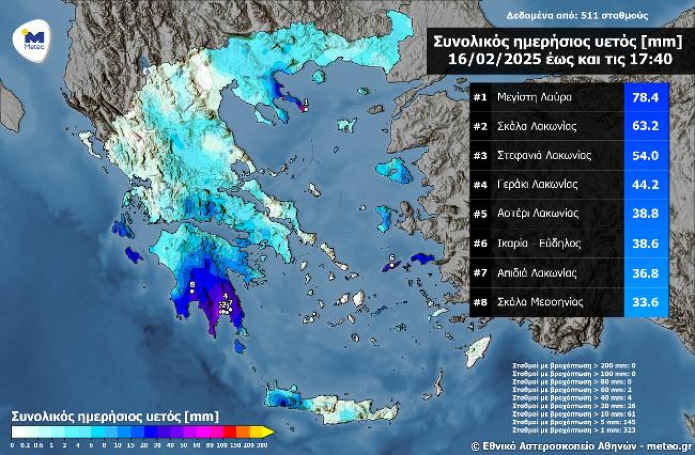
Significant Rainfall Yesterday in the Northeast and Southern Peloponnese
Heavy rainfall was recorded until Sunday afternoon (16/02) in Mount Athos and parts of Southern Peloponnese, as seen in the map below. The highest rainfall amount recorded by 17:40 was at the weather station in Megisti Lavra, with 78.4 millimeters.
The map below displays total rainfall amounts up until 17:40 on Sunday, 16/02, as recorded by 511 meteorological stations from the National Observatory of Athens / meteo.gr’s automated weather network, highlighting the eight highest readings.
Today’s Weather
Increased cloud cover with local showers is expected across most of the country. Scattered thunderstorms will occur in the Eastern Aegean, the Dodecanese, the Cyclades, and Crete. Snowfall will affect northern mountainous areas and, from the evening, also higher elevations.
Temperatures will range as follows:
- North: 3 to 12°C
- Epirus: 4 to 15°C
- Thessaly: 6 to 15°C
- Peloponnese: 3 to 17°C
- Central Greece: 5 to 17°C
- Northern Aegean Islands: 10 to 16°C
- Central & Southern Aegean: 11 to 17°C
- Ionian: 8 to 17°C
- Crete: 9 to 18°C
Winds will blow from northern directions, southeasterly in the east, at 3 to 5 Beaufort, while in the Northeastern Aegean, they will reach up to 6 Beaufort from the northeast.
Athens: Overcast with local showers. Winds variable at 2 to 4 Beaufort. Temperatures between 9 and 17°C.
Thessaloniki: Partly cloudy with occasional local showers. Winds variable at 2 to 4 Beaufort. Temperatures between 7 and 12°C.
Tuesday, 18/02/2025 Weather
In the eastern and northern mainland and the Aegean, cloudy skies with local showers, and isolated thunderstorms possible in the Dodecanese during the morning. Elsewhere, occasional cloud cover with chances of brief local showers, mainly in central and southern regions. Snow will fall in central and northern mountainous areas, as well as in hilly areas of the north, and possibly in lower-altitude areas of Eastern Macedonia and Thrace. Visibility will be locally limited in western mainland areas during the morning, with fog forming in some places.
Winds from the north at 3 to 5 Beaufort, and in the Northern Aegean, locally reaching 6 Beaufort.
Temperatures will drop in central and northern regions, reaching:
- 7-9°C in northern mainland & Northeast Aegean islands
- 16-17°C in western & southern islands
- 18°C in Crete and the Dodecanese
- 10-14°C in most other areas (up to 15°C in the south)
Frost is expected locally in northwestern mainland areas.
Wednesday, 19/02/2025 Weather
Overcast skies with local showers in eastern and southern mainland regions, Sporades, Euboea, Crete, and occasionally in northern mainland, Northern Aegean islands, and the Cyclades. Snowfall in the mountains, in hilly areas of central and northern Greece, and possibly in lower-altitude areas of Eastern Macedonia and Thrace.
Winds:
- West: North-northwest 4-5, locally up to 6 Beaufort in the Ionian
- East: North-northeast 4-5, up to 7 Beaufort in the Aegean
Further temperature drop, most noticeable in central and northern areas, with frost occurring locally in mainland areas.
Thursday, 20/02/2025 Weather
Similar conditions with continued cold temperatures. Local showers and snow in mountainous and hilly areas. Winds from the northeast at 4-7 Beaufort, reaching 8 Beaufort in the Dodecanese.
Friday, 21/02/2025 Weather
Cloudy with light local showers in eastern mainland, Sporades, Euboea, Crete, and temporarily in northern Greece. Light snowfall mainly in mountainous and hilly areas.
Winds from the north at 4-7 Beaufort, with no significant temperature change, keeping conditions colder than normal for the season. Frost expected in central and northern mainland regions.
Ask me anything
Explore related questions