
The cold front, which is the main feature of the Coral storm, has been felt since early this morning, bringing snow to many mountainous areas and will continue at least until Sunday evening.
According to the updated emergency bulletin from the Hellenic National Meteorological Service (EMY), today, Thursday, snow will fall in mountainous and semi-mountainous areas, and locally in lower altitudes in Central Macedonia, Thessaly, Central and Eastern Sterea, Eastern Peloponnese, Evia, and the northern Aegean islands, as well as in the mountains of Crete.
Tomorrow, Friday, snow will fall in mountainous, semi-mountainous, and locally in lower altitude areas in Macedonia (mainly central), Thessaly, Central and Eastern Sterea (including Attica), Eastern Peloponnese, Evia, the northern and central Aegean islands, and Crete.
Attica
As for Attica, meteorologist Yiannis Kallianos explains in a Facebook post that “the weather will have variations, with periods of denser clouds but also clear spells. When the clouds thicken, local snowfall will occur, mostly weakened, especially in the following areas of the region:
- Northwest
- North
- Northeast
- East
The local snowfall will reach altitudes of 150-200 meters, which is quite low. However, they will generally be light, while in the northern parts of the region and near mountainous areas, the snowfall may be a bit more significant, but they won’t be intense or cause any major problems. There will be no severe weather.
Therefore, in general, Attica will not experience much snow, unlike other similar cold spells. The coldest days for Attica will be Friday and Saturday. On Sunday morning, if the low temperatures persist, there is a slight chance of local snow at relatively low altitudes.”
Watch videos from Parnitha, where snow started falling early this morning.
On the other hand, the head of weather forecasting at EMY, Theodoros Kolydas, mentions in anticipation of the next update of the emergency bulletin that “we will provide detailed information about the developments, which can be summarized in the continuation of low temperatures and strengthened northern winds in Eastern and Southern Greece. Periodically, there will be light to moderate snowfall in Eastern Thessaly, Phthiotis, Boeotia, Evia, and secondarily in other eastern areas of the country, Central Macedonia, and the mountains and semi-mountains of the Cyclades and Crete. In Attica, periodic light snowfall will occur mainly in the mountains, semi-mountains, and higher northern suburbs.”
ΜΙΑ "ΣΤΑΓΟΝΑ" ΜΕΤΕΩΡΟΛΟΓΙΑΣ
— Theodoros Kolydas (@KolydasT) February 20, 2025
✅ Μεταξύ πολλών μετεωρολογικών παραμέτρων οι θερμοκρασίες στα 850hPa και τα 500hpa διαδραματίζουν μεγάλο ρόλο για τη δημιουργία χιονοπτώσεων στον Ελληνικό χώρο .
✅ Στο εγχειρίδιο του Μετεωρολόγου προγώστη της ΕΜΥ περιγράφονται αναλυτικά τα κριτήρια… pic.twitter.com/rDmfUrKTxC
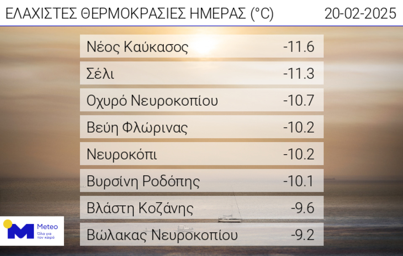
Temperatures Reached -11°C
According to the network of automatic meteorological stations from meteo.gr / National Observatory of Athens, the lowest temperature was recorded in Neos Caucasus (-11.6°C), followed by Selio (-11.3°C) and Ochyro Nevrokopiou (-10.7°C).
Evia
Snowfall in areas of Evia began yesterday morning, with many mountainous villages being covered in white.
Today, residents of the mountain village of Setta woke up to snow. This is the mountain village in the Municipality of Eretria, which gets covered in white every year. As seen in the video from evima.gr, the snow has covered the roofs of the houses, but so far, no problems have been reported.
Snow in Setta
Lesvos
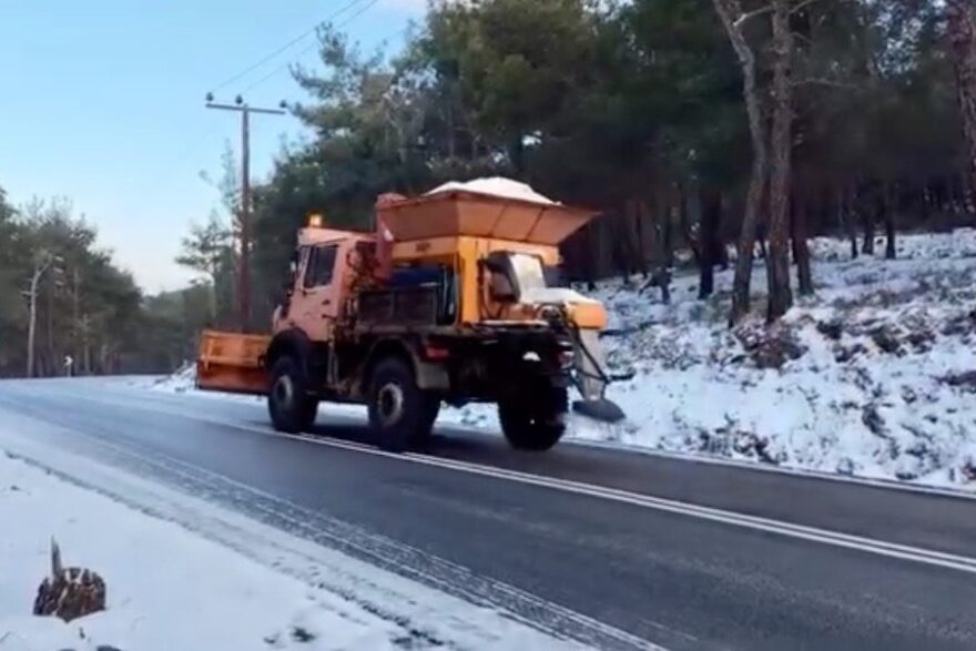
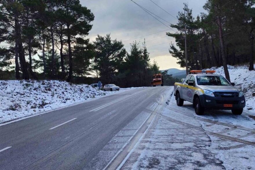
Snowfall and frost were reported early this morning in Lesvos, particularly in the areas of Megali Limni, Ahladeri, and Vasilika.
The Regional Authority immediately activated snow removal machinery to spread salt, aiming to restore road safety and maintain the passability of the roads.
The Emergency Bulletin from EMY
The updated emergency weather worsening bulletin from EMY is in full effect, predicting freezing temperatures and snow in many areas of the country.
As stated in the emergency bulletin, for today, Thursday, the following are expected:
Polar Temperatures
a) In Central Macedonia and Thessaly from -4°C to 7-8°C.
b) In Central, Eastern Sterea, and Evia from -2°C to 9-10°C.
Snow
a) In Central Macedonia, Thessaly, Central and Eastern Sterea, and Evia, snow will fall in the mountains and semi-mountains from the morning hours, gradually spreading to lower altitudes.
b) In the mountains of Crete from the morning hours, gradually spreading to semi-mountainous areas.
For tomorrow, Friday (21.02.2025), the following are expected:
Freezing Temperatures:
a) In Eastern Macedonia, Thrace, and the islands of the northeastern Aegean from 5°C to 4-5°C, and in Western and Central Macedonia from 4°C to 5-6°C.
b) In Thessaly, Central and Eastern Sterea, and Evia from -1°C to 7-8°C.
c) In Eastern Peloponnese from 0°C to 9-10°C.
Snowfall
a) In Western and Central Macedonia, Thessaly, the northern and eastern Aegean islands, Central and Eastern Sterea (including Attica), Evia, and Eastern Peloponnese, snow will fall in the mountains, semi-mountains, and lower-altitude areas from the morning hours.
b) In the mountains and semi-mountains of Crete.
Weather for Friday, 21-02-2025
In Macedonia, Thessaly, the Sporades, Central and Eastern Sterea, Eastern Peloponnese, Evia, the Aegean (excluding the Dodecanese), and Crete, cloudy weather with rain or sleet is expected. In the rest of the country, there will be few clouds, temporarily increasing. Snow will fall in Macedonia (mainly Central), Thessaly, Central and Eastern Sterea (including Attica), Eastern Peloponnese, Evia, and the islands of the northern and central Aegean, in the mountains, semi-mountains, and locally in lower-altitude areas, as well as in the mountains and semi-mountains of Crete.
Winds will blow from the east at 4-5 Beaufort, locally 6 Beaufort in the southern seas. In the east, they will blow from the north-northeast at 4-6 Beaufort, and in the Aegean, 7, locally 8 Beaufort. In the Dodecanese, winds will blow from the north-northwest at 6-7 Beaufort.
Temperatures will drop slightly further and remain below normal for the season. Specifically, in the north, temperatures will reach 5-7°C, in the central areas 7-9°C, in the west 10-12°C and locally 13°C, and in the southern islands, 9-11°C and locally 12°C. Frost will occur in parts of the central and northern mainland in the early morning and evening hours.
Ask me anything
Explore related questions


