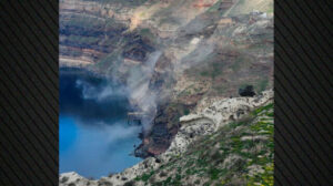
The scientific community is closely monitoring the issue of landslides in Santorini, especially given the increased seismic activity recorded in the sea area between Santorini and Amorgos in recent times. On Saturday morning, a team from the Remote Sensing Laboratory, led by its director, Professor Manolis Vasilakis, visited the region. Using state-of-the-art short-range remote sensing equipment, they aim to map areas where landslide phenomena—frequent on the island—may worsen.
This new study is part of a series of actions initiated by EKPA through the Interdisciplinary Risk and Crisis Management Committee, which was established in response to the heightened seismic activity in the area.
The data will be collected using modern, innovative equipment, specifically unmanned aerial vehicles (UAVs) equipped with high-resolution cameras and LiDAR sensors. These will provide highly precise and detailed information on slope erosion.
As Professor of Remote Sensing and Morphotectonics, and director of the Remote Sensing Laboratory at EKPA’s Department of Geology and Geoenvironment, Manolis Vasilakis, explains to the Athens-Macedonian News Agency, the study will focus on areas with high risk and significant human presence.
These areas, he states, include Athinios Bay, the Old Port, Ammoudi, Armeni, and Korfos in Thirasia. The Remote Sensing Laboratory team from the Department of Geology will apply cutting-edge technology to study changes in the earth’s surface along the slopes of these areas.
“We are studying surface changes on these slopes using various methodologies that rely on the latest technology, such as drones equipped with specific sensors—either high-resolution cameras or LiDAR sensors, which capture a cloud of hundreds of millions of points, depending on the area they are deployed to map,” explains Professor Vasilakis, emphasizing that long-term monitoring is a key factor in the study.
“By processing the collected data, we can identify spots that are at risk of collapsing with the slightest tremor from an earthquake or extreme weather conditions—such as heavy rainfall, which accelerates erosion on these slopes,” he explains. He further notes that landslides and rockfalls are caused by the nature of the rock and the steep inclines of the caldera’s slopes.
Through systematic and repeated mapping of critical areas, it will be possible to pinpoint locations with an increased likelihood of rockfalls and landslides. The same spatial data will also be used to simulate rockfall trajectories, allowing experts to propose appropriate protective measures.
The research team is expected to begin their work in Ammoudi, Armeni, and Thirasia, with the Old Port being a particularly noteworthy case, according to Professor Vasilakis.
“The Old Port is a major attraction in its own right, but it has issues. Landslides have been observed, including near the cable car, and the fences are filled with debris from previous collapses, which need to be cleared. We document and quantify all these factors, making them known to the relevant authorities,” he notes, adding that by the end of next week, they must propose some short-term measures that need to be taken. “Beyond that, we will continue our research to suggest more long-term solutions,” he tells the Athens-Macedonian News Agency.
Regarding Athinios, Professor Vasilakis highlights that some measures have already been taken and that the landslides currently occurring are not particularly hazardous since they are outside the road network.
“There are areas that have been collapsing, will continue to collapse, and where rockfalls will keep occurring. But since they don’t affect human activity, we let nature take its course. These landslides and rockfalls would have happened one way or another—it’s not human-induced,” he clarifies. Regarding the protective nets that have been installed in various locations, he states that they were placed based on recommendations from a previous study but now require maintenance and updates.
At the next stage of the study, satellite data from the Greek microsatellites already in operation (https://hsc.gov.gr/) will be utilized to monitor long-term surface changes in the islands of Thira and Thirasia, as well as temperature variations across the Kameni volcanic islets.
According to Professor Vasilakis, if necessary, the team will travel to Kameni to pinpoint suitable locations for installing detection devices or radars aimed at monitoring the slopes. They are considering four locations: across from Fira and Firostefani, opposite Oia, and potentially one more site on Kameni or a location in Thirasia.
Additionally, they are exploring the possibility of installing two more detection devices at the Old Port—one directly facing the slope where the cable car descends and another to cover the entire remaining area. “These are devices used internationally for monitoring landslides and avalanches. They operate 24/7, sending alert messages whenever movement is detected,” explains Professor Vasilakis.
Ask me anything
Explore related questions