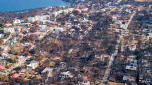
The total redevelopment of the sensitive area at Mati, seven years after the tragic event of the catastrophic fire, the government is ratifying the project by offering a safety net of safety and protection with five urban units in off-planned areas, totalling 2,579 hectares in Nea Makri and Rafina.
A joint ministerial decision approves the Implementation Plan (determines roads, plots, common areas, building conditions) and at the same time ratifies the Application Plan for the fire-affected area of the Municipal Unit of Nea Makris of the Municipality of Marathon and the Municipal Unit of Rafina of the Municipality of Rafina-Pikermio. The same Decision also approves the environmental conditions of all the projects (hydraulic and port), as well as an iconic Coastal Walk.
The aim is the safety of residents and visitors, sustainable development, shielding from natural disasters, and optimal use of public space with new and larger roads, squares, public green spaces, sidewalks, and public spaces.
According to the ministry, it is the first time in Greek urban planning data that the Town and Country Planning Plan and the environmental conditions of all planned projects are approved simultaneously by a Joint Ministerial Decision and the Act of Implementation of the Plan is ratified, forming conditions for the immediate implementation of the approved planning.
The 7 main interventions of the RSP
1. Combination of 5 Planning Units, with a total area of 2,579 ha. which until now were developed as off-plan areas in the Municipalities of Marathon and Rafina-Pikermio, covering 2,571 properties and 3,962 owners. In the Municipality of Marathon, 2 Urban Units are created, with a total area of 1,507 ha, Agia Marina and Mati. In the Municipality of Rafina – Pikermio, 3 Urban Units are created, with a total area of 1,072 ha, Kokkino Limanaki, Skoufika and Peikonas.
Section 1, Kikhonikone and Pikhonikone are located in the area of Kikhonikone, in the area of Kikhonikone and Pikhonikone.
2. In the 5 new Urban Planning Units (2,579 ha in total), layout and building lines are defined and provided for:
– Buildable areas of 1,832 ha,
– 152 ha of common areas, including 120 ha for common green areas and 32 ha for squares, shelters/population gathering places, and parking areas.
– Public spaces 109 ha.
– Vehicle traffic network 352 ha
(New road widenings totalling 41,604 m are added to the existing roads with a total length of 64,738 m. The total network will be extended to 106,342 m, an increase of 64.2%.
– Pedestrian sidewalks
– 6 watercourse zones,
3. Defined land use, building conditions, and restrictions
Pure residential use is established in the entire area of the RSE, while in some area,s only general residential use is allowed with restrictions.
4. Zones Geologically Suitable or Unsuitable for Building are defined, with the aim of seismic shielding of the area, as well as avoiding areas with landslide phenomena.
5. Definitively delineate and designate 9 watercourses and provide for 10 flood control and regulation projects (small dams). This will achieve a reduction in the area of the flood zone of the watercourses by up to 91.2% in comparison with the existing situation.
6. Approved coastal and coastal engineering works to protect the coast from further erosion and slope erosion.
7. The construction of the Coastal Walk is approved, which will be a new landmark and attraction for the area.
This is an iconic project and landmark that transforms the coastline into an attractive recreational destination. The Coastal Walk, with a total length of 3.87 km and a minimum width of 3.5 m, will connect the coastline from Agios Andreas to Kokkino Limanaki, exploiting the existing geomorphology and protecting the coastline from erosion. The Coastal Walk will connect Poseidonos and Democritus avenues through existing and new access routes, serving pedestrians and cyclists, while in its largest part, accessibility to disabled people and people with reduced mobility is ensured.
Five years of preparation
The completion time of the overall urban planning of the first and second level, i.e., the Special Urban Plan and the Urban Implementation Plan (EAP and RAP), took a total of 5 years, given the many peculiarities and pathologies of the area. It should be noted that the completion of these processes to date has taken an average of 20-30 years, and in any case, without the specifications and in-depth studies prepared for the redevelopment in Mati. It should be recalled that the reconstruction of the fire-affected area essentially began on 10/02/2020 with the signing of the contract for the preparation of the Special Urban Plan (SPP), which was published on 07/06/2022 (Government Gazette D’ 398/2022). With the approval of the SPP and its environmental conditions, the area acquired level A urban planning. Level B planning began with the signing of a contract for the preparation of the Urban Development Plan (UDP) on 29/07/2021. In fact, due to the need for rapid redevelopment of the area, it was chosen to adopt the RSE using an EIA instead of a PD, as provided as a possibility in Article 10 of Law no. 4447/2016.
The Minister of Environment and Energy, Thodoros Skylakakis, said, “A new era of reconstruction is beginning for Mati. With one decision, the Town and Country Plan proceeds and at the same time the Implementation Act for the fire-affected area of the Municipal Unit of Nea Makris of the Municipality of Marathon and the Municipal Unit of Rafina of the Municipality of Rafina – Pikermio is ratified, while the environmental conditions of all the projects (hydraulic and port), as well as an iconic Coastal Walk are approved. I thank the Deputy Minister of Environment and Energy, Nikos Tagaras and the Secretary General of Spatial Planning and Urban Environment, Efthymios Bakoyannis, for the very difficult task they have accomplished”.
Deputy Minister of Environment and Energy Nikos Tagaras, who took charge of all the planning, said that the urban plan for Mati is a flagship holistic plan that is a “pilot” for urban regeneration, environmental restoration, and shielding.
The completion of both levels of planning (Special Urban Plan and Town and Country Plan) with the simultaneous environmental approval of all planned projects within 5 years is considered a particularly demanding and ambitious undertaking, as he stresses. “On the one hand, because we have been called upon to redesign an already built-up area with numerous urban planning and environmental issues. In its urban planning dimension, Mati is essentially a miniature of the pathologies of the whole country. On the other hand, we have simultaneously completed the planning and environmental approvals of the necessary projects in a very short time by Greek standards. The final result of this multi-level and demanding process required the cooperation and coordination of many stakeholders – services and ministries – under the daily supervision and guidance of the Ministry of Environment and Energy, while exhausting every scope for consultation with interested citizens, bodies and, of course, the first and second level local authorities. I thank them all warmly!”
10 Questions – Answers on the Implementation Plan for the Mati Spatial Implementation Plan
1. What is the Spatial Implementation Plan?
The Spatial Implementation Plan (RMP) is the B-level urban plan that is the detailed planning of the urban organization with simultaneous implementation on the ground. It defines roads, plots, common areas, and building conditions in an area. It is required for the issuance of building permits.
2. What is the purpose of the RSE for Mati?
Its purpose is the total redevelopment of the fire-affected area in Mati into 5 Urban Units, which are currently out of plan. Agia Marina and Mati in the Municipality of Marathon and Kokkino Limanaki, Skoufeika and Peikonas in the Municipality of Rafina – Pikermio.
3. How is Mati being shielded through the overall planning to prevent a similar tragedy from happening again?
The shielding of the area is achieved by an integrated package of measures involving large-scale urban, environmental, and technical interventions. With the implementation of what the RSE foresees for Mati, a new, protected area is created, a model not only for Attica but for the whole country.
To understand the magnitude of the whole planning process, it is emphasized that the following studies were carried out in the framework of the RSE:
Topographical – Land Survey and Implementation Act
Geological Suitability Study
Transport – Traffic Study
River Delimitation Study
Preliminary design of stream regulation and flood protection projects
Shore engineering study
Geological and Geotechnical Study of the response to landslide phenomena of coastal slopes
Environmental Impact Assessment of the planned projects in the area of the EIA
Final Design of Port Projects for the Protection of the Coast
Final Hydraulic Study for the settlement of watercourses and flood protection works.
4. Why are large-scale interventions needed to make Mati safe and sustainable? What are the characteristics of the area that led to a new, comprehensive, radical reorganisation plan?
During the preparation of the RSE, all the issues – pathologies of an off-plan area that led to the need for a radical reorganization of the site – emerged. Initially, the planning process addressed many urban, property, and environmental issues with key data:
– The lack of public and common areas, with few squares, parks, and public spaces; 49% of the plots were under 500 sqm; 62% of the properties were already built up (with many unauthorized buildings), making it difficult to build on them.
– The rudimentary and inadequate road network, as the roads are narrow (<4 m or with a variable width of 4-6 m), resulting in unsafe traffic, especially for emergency vehicles. There are also many blind spots and dead ends, hence great difficulty to escape in case of danger.
– The area under urbanization lacks fire protection zones as well as organized flood control infrastructure.
– In addition, the coastal front is subject to intense erosive phenomena with the risk of loss of soil and infrastructure.
5. What does the plan provide for improving both access and safe evacuation in case of emergencies?
The zoning envisaged in the RSP creates a buildable area of 1,832 acres with 152 acres for public spaces (of which 120 acres for greenery,32 acres for plazas and population gathering places, 109 acres for common areas,105 acres for sidewalks, and 29 acres for watercourse zones).
The plan also provides for the radical restructuring and upgrading of the road network with road crossings, new road openings, new intersections, one-way streets, as well as the design of pedestrian crossings, enclosed parking spaces, ramps for the disabled, blind routes, bike lanes, and tree rows.
In particular, the road network is increased by 64.2% compared to the existing road network. Of the 64,738 m of roads currently, new road widenings of an additional 41,604 m are planned, resulting in a total road network of 106,342 m with a hierarchy and the aim of creating a network of collector roads, which will channel local traffic to the main roads (Marathon Avenue and Fleming Avenue) in the region, with safe level connections.
The entire area is provided with highly accessible, low-traffic roads with a speed limit of 30km/h for the entire area to be developed, both on the local and the hierarchical road network (collector roads).
It becomes clear that with the above-mentioned interventions, Mati acquires road access, safe pedestrian and vehicular traffic, and escape routes to and from the coastal front and the main roads.
6. How are residents shielded from severe natural events? Accordingly, what provision has been made for coastal erosion?
With the RSE, the area is environmentally shielded through an integrated planning process that includes flood protection, stream management, coastal erosion projects, natural environment enhancement, and sustainable urban development.
Regional development, including environmental protection, sustainable development, sustainable urban planning, and sustainable environmental management.
In particular, in addition to the urbanisation of the area mentioned above, 9 watercourses are being delineated and managed in an area that had an unorganised hydrological system. 10 flood protection works (small dams) are planned, reducing the flood zones by up to 91.2%. At the same time, to shield the area from earthquakes and landslides, geological suitability zones are being created to prevent building in areas where there is a risk of landslides. The need to tackle coastal erosion, port and coastal engineering works, the creation of reefs, breakwaters, and jetties, and the enrichment of existing beaches with mild interventions are envisaged. It is emphasized that the design of the Coastal Promenade also includes special erosion protection works. With all these intervention measures, the area is transformed into a resilient, safe, and environmentally protected residential community.
7. Why is the completion of the design in 5 years considered fast?
It took 5 years to complete all 2 phases of urban redevelopment planning for the area – the EIA and the RDA. Essentially, it started on 10/02/2020 with the signing of the contract for the preparation of the Special Urban Plan (SIP). This Presidential Decree was issued on 10/06/2022 (Government Gazette D398/2022) and was followed by the second level of planning, respectively, with the signing of the contract for the preparation of the Urban Implementation Plan (IPP) on 29/07/2021. With today’s EIA for the reconstruction in the fire-affected area, at the same time, the Spatial Plan is approved and the Act of Implementation of the Special Urban Plan (SIP) of the fire-affected area of the Municipal Unit of Nea Makris of the Municipality of Marathon and the Municipal Unit of Rafina of the Municipality of Rafina-Pikermio is ratified. In addition, the environmental conditions of all the projects (hydraulic, port) foreseen and described in the EIA are approved, as well as the Coastal Promenade foreseen on the coastline.
Similar procedures in Greece have so far taken, on average – with the ratification of the Implementation Act – about 20-30 years. Despite the complexity in environmental, urban planning and institutional-legal issues, the overall planning “ran” at a significantly higher speed despite the many urban planning and environmental issues in the area.
It is worth noting that a total of 25 institutions, ministries, and local authorities were involved, while 14 meetings of the KESYPOTHA (Central Council for Urban Planning Issues and Disputes) were held. The rapid redevelopment of the area necessitated the choice of a Joint Ministerial Decision (JMD) instead of a Presidential Decree, as allowed by Article 10 of Law 4447/2016.
8. What will be allowed to be built in the fire-affected area? What does the RSE provide for land use?
The entire area of the RSE is designated for pure residential use. Only on the faces of the lots on Fleming Avenue, in the “Skoufika” Planning Unit, and in the “Pefkona” Planning Unit are general residential uses allowed, with exceptions.
9. Why is the Coastal Promenade provided for in the RSE considered a new iconic landmark in the area?
The Coastal Promenade symbolizes the transition from disaster to rebirth, elevating the area after the 2018 tragedy. It was designed to provide a safe, functional, and stylish space for residents, honoring the memory of the fire victims.
It is designed to accommodate pedestrians, cyclists, and runners along its entire 3.87km length, creating a new landmark for the area. It forms part of the wider ‘green’ network of the sustainable urbanisation area and is developed on the coastal boundary of the properties, with natural design interventions. The Coastal Promenade will be accessible to people with disabilities and reduced mobility, will include a two-way cycle route in the areas of Kokkino Limanaki and Mati, and will have recycling streams for waste management and reduction of the environmental footprint.
10. How was the participation of residents and stakeholders in the final design of the RSE ensured? Was there any opposition or difficulties? How were these dealt with?
The whole process was characterised by strong participation and dialogue, with the aim of a design that serves both residents and visitors and the overall development of the area in a sustainable manner. There were several reactions and challenges, especially on issues of zoning, common areas and property regulations, as well as land issues with the Implementation Act. However, resident and stakeholder participation in the RSE planning process was exhaustive and ensured through the following:
– Open public consultations, which lasted over 4 months.
– an online platform (https://rsemati.gov.gr) where owners could submit statements and objections.
– opinions from more than 25 bodies, including ministries, local authorities, and scientific committees.
– participation of more than 150 individuals and 10 associations and unions in the public consultation procedures.
16 five-day extensions were granted for the submission of objections to ensure full participation of citizens. All objections were examined one by one, based on urban planning and legal criteria. 14 meetings were held at the Central Council for Urban Planning Issues and Disputes (KESYPOTHA) to achieve the best solution for citizens and local government.
Ask me anything
Explore related questions


