
Specifically, snowfall is occurring in some areas of Halkidiki, Thessaly, and Phthiotis. Additionally, intense storms are affecting several regions of Attica, Peloponnese, Central Greece, Thessaly, and Macedonia.
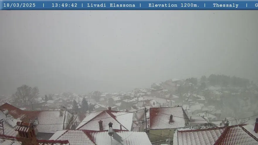
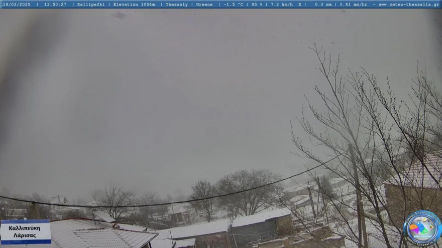
“Covered in White” in Mountainous Communities of Larissa Region
The mountainous areas of the Larissa Region, specifically the communities of Kallipefki and Livadi Olympus, have already been covered in snow by Tuesday afternoon, as reported by larissanet.gr.
Snowfall in Larissa
Snowfall has begun in Larissa, with the snowflakes covering the area.
Snow in Halkidiki
A white blanket has covered Neochori and Arnea in Halkidiki by Tuesday afternoon, as thestival.gr reports, with ongoing snowfall in the area.
Despite the intense cold, traffic on the road network is moving without problems so far. However, drivers are urged to be cautious as the temperature remains low, increasing the risk of frost.
Meteorological forecasts indicate that these conditions may continue, with local authorities on alert for any necessary interventions.
Snowfall Begins in Mountainous Phthiotis
In western Phthiotis, the storm began shortly after 16:30. According to lamiareport.gr, snow is falling in Gardiki Omilion, Rahi Tymfristou, and the mountainous villages of Domokos.
Storms in Attica
Intense storms are hitting several areas of Attica, Peloponnese, Central Greece, Thessaly, and Macedonia.
These weather phenomena are expected to continue on Wednesday (19/3) and Thursday (20/3), but from Friday, temperatures will begin to rise again.
Meteorological Report
“The weather change is today with the cold front that will quickly lower the temperature from north to south throughout the country. We have already said that there will be an impressive drop in temperature. In some areas, the temperature will drop by 20 degrees compared to the very high temperatures we had over the weekend. We will also have some sleet and snow at relatively low altitudes, mainly in eastern parts of the country,” said Kostas Lagouvardos, meteorologist and director of research at the National Observatory of Athens (meteo.gr).
Temperature Rise Expected on Friday
“In Attica, we have and will have rain through tonight and until tomorrow morning, and some sleet in certain northern suburbs, with snow at higher altitudes. The phenomena will stop by Wednesday, so the cold will remain on Thursday, with strong frost in the northern parts of the country. However, from Friday, temperatures will start rising again, and this rise will likely be quite significant, with very high temperatures expected early next week,” adds Kostas Lagouvardos.

Forecast for Wednesday (19/3)
According to meteo.gr, tomorrow, Wednesday, rain is initially expected in Thessaly, Central and Eastern Sterea, Eastern Peloponnese, Cyclades, and Crete. Snow will fall in the mountains and semi-mountains of Thessaly, Central and Eastern Sterea, Eastern Peloponnese, and the mountains of Crete. Gradually, these phenomena will weaken, and by midday, they will stop.
In Western Macedonia, temperatures will range from -6 to 8°C, in the rest of Macedonia and Thrace from -2 to 12°C, in Thessaly from 1 to 12°C, in Epirus from -1 to 14°C, in Western Sterea from 2 to 13°C, in the rest of Sterea from 2 to 11°C, in Western Peloponnese from 3 to 15°C, in the rest of Peloponnese from 1 to 12°C, in the Ionian Islands from 5 to 14°C, in the Northern and Eastern Aegean Islands from 4 to 10°C, in the Cyclades from 6 to 11°C, in the Dodecanese from 9 to 15°C, and in Crete from 8 to 13°C. The minimum temperature in the Dodecanese and Crete is expected towards the end of the day.
Winds in the Northern Aegean will initially blow from northern directions at 5 to 7, locally 8 Beaufort, gradually weakening from north to south. In the Ionian, winds will initially blow from eastern directions at 3 to 5 Beaufort but will shift to northwesterly at 2 to 4 Beaufort by midday.
In Attica, initial cloudy weather with rain and snow in the mountainous areas will improve quickly, and by the morning, there will be sunshine. Winds will blow from northern directions at 3 to 5 Beaufort, and in the eastern and southern parts, 4 to 6 Beaufort, gradually weakening by midday. The temperature in central Athens will range from 6 to 11°C.
In Thessaloniki, initial cloudy weather will give way to sunshine from the morning. Winds will blow from variable directions up to 2 Beaufort. The temperature in central Thessaloniki will range from 2 to 12°C.
Ask me anything
Explore related questions


