
From Friday night (March 28), strong showers and thunderstorms will hit the Ionian Islands, western mainland Greece, and the Peloponnese. These conditions will persist through the night but are expected to ease by midday on Saturday, according to forecasts from Meteo.gr / National Observatory of Athens.
On Saturday (March 29), instability will continue across the rest of the country. From the morning, localized showers and sporadic thunderstorms will develop, gradually intensifying by midday, becoming more widespread.
Weather Outlook for Athens & Thessaloniki on Saturday
- Athens: Rain is expected from the morning, with scattered thunderstorms developing towards midday. Conditions will improve by the afternoon.
- Thessaloniki: Cloud cover will gradually increase, bringing showers and possibly isolated thunderstorms later in the day.
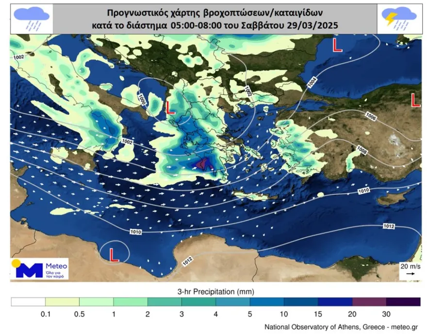
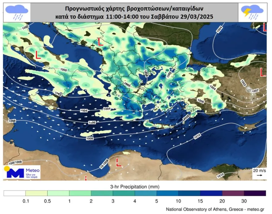
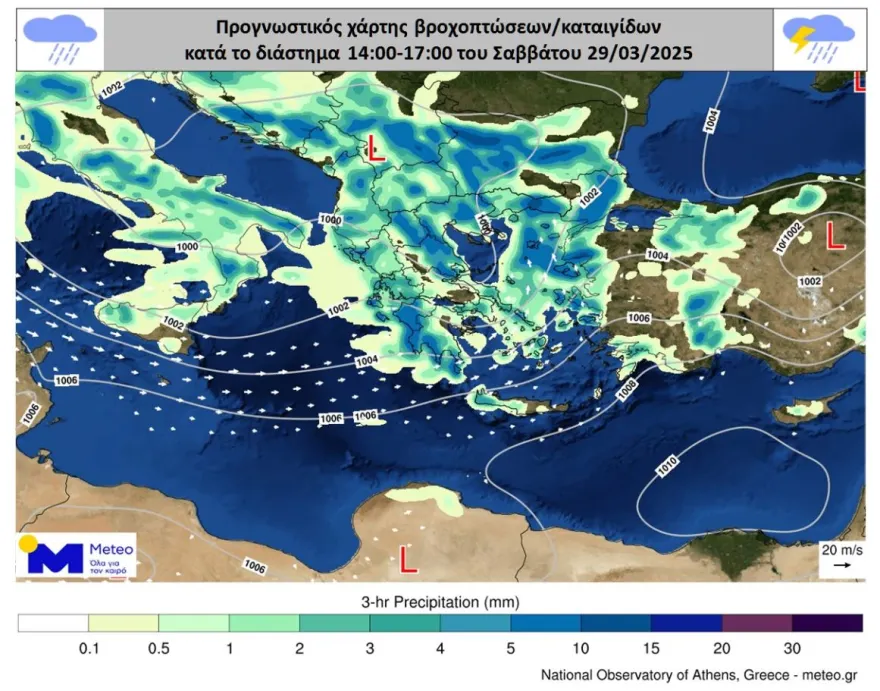
The forecast maps show expected precipitation distribution across the country at the following intervals: 05:00 – 08:00, 11:00 – 14:00, and 14:00 – 17:00 on Saturday, March 29.
Detailed Forecast for Saturday – National Meteorological Service (EMY)
A highly unsettled weather pattern will dominate the country, featuring widespread cloud cover, local showers, and thunderstorms. The most intense conditions are expected in western Greece, the Aegean Sea, and later in the afternoon across the mainland. Severe thunderstorms are possible over the Eastern Aegean islands, the Ionian Sea, western Peloponnese, and western Crete, continuing into the evening over the Dodecanese. Snowfall is expected in mountainous regions.
Winds will blow predominantly south-southwesterly at 3-5 Beaufort, while temperatures will see a slight drop, reaching 16°C in the west and north, and 18-19°C in the east and south.
Regional Breakdown:
Macedonia & Thrace
- Conditions: Unstable, with intervals of increased cloud cover, showers, and isolated thunderstorms, mainly in the afternoon. Light snowfall expected in the mountains.
- Winds: Variable, 3-4 Beaufort; in coastal areas, east-southeasterly.
- Temperature: 8-16°C (Western Macedonia: 4-12°C).
Ionian Islands, Epirus, Western Mainland Greece, Western Peloponnese
- Conditions: Cloudy with rain and scattered thunderstorms. Locally intense storms likely in the Ionian and western Peloponnese until the afternoon. Light snowfall expected in the mountains.
- Winds: South-southwesterly, 3-5 Beaufort.
- Temperature: 10-16°C (colder inland in Epirus).
Eastern Mainland Greece, Euboea, Eastern Peloponnese
- Conditions: Periods of increased cloud cover with showers and occasional thunderstorms, mainly in the afternoon. Light snow possible in the mountains.
- Winds: West-southwesterly, 3-5 Beaufort, briefly 5-6 Beaufort in southern Peloponnese.
- Temperature: 10-18°C.
Cyclades & Crete
- Conditions: Unsettled with showers and isolated thunderstorms. Western Crete may experience locally intense storms until midday.
- Winds: West-southwesterly, 4-6 Beaufort.
- Temperature: 13-18°C (Crete up to 19°C).
Eastern Aegean Islands & Dodecanese
- Conditions: Cloudy with rain and scattered thunderstorms. Strong storms are expected in the Eastern Aegean and Dodecanese from the afternoon.
- Winds: South-southwesterly, 4-6 Beaufort.
- Temperature: 14-19°C.
Thessaly
- Conditions: Unsettled, with cloudy periods, showers, and isolated thunderstorms, especially in the afternoon. Light snowfall expected in the mountains.
- Winds: Variable, 2-3 Beaufort.
- Temperature: 8-16°C.
Attica (Athens & Surrounding Areas)
- Conditions: Increasing cloud cover throughout the day, with afternoon showers and isolated thunderstorms, mainly in the western and northern suburbs.
- Winds: South-southwesterly, 3-4 Beaufort.
- Temperature: 11-18°C.
Thessaloniki & Central Macedonia
- Conditions: Overcast with rain and scattered thunderstorms developing from midday onwards.
- Winds: Light, 2-3 Beaufort.
- Temperature: 10-16°C.
Ask me anything
Explore related questions