
Meteorologists warn that a significant weather system bringing rain, thunderstorms, and hail is affecting parts of Greece, with the most intense conditions expected today and tomorrow. A cold air mass originating from the Balkan region is driving this brief but potent instability, requiring citizens to exercise caution due to the potential for locally dangerous phenomena.
Key Weather Developments
Strong thunderstorms accompanied by lightning and hail are anticipated from today through the coming days, with the phenomena gradually diminishing by Sunday, June 2. Following this period, a marked shift toward summer conditions and rising temperatures is forecasted for the start of next week.
Affected Regions
The core of this weather instability will impact:
– Mainland Greece, particularly central and northern regions
– Eastern and southern coastal areas, especially from Friday to Saturday
– Island groups, including Crete, Cyclades, and Dodecanese
Forecast Summary
According to expert meteorologist Klearhos Marousakis, the cold air mass in the upper troposphere—originating from the northwestern Balkan region—is set to trigger intense thunderstorms over several mainland areas, with increased lightning activity, heavy rainfall, and hail. During the weekend, this instability will shift toward the eastern and southern maritime zones, before gradually subsiding on Sunday.
Marousakis emphasizes caution: “We are exercising due vigilance as these phenomena can be locally intense and dangerous. The forecast maps from our system illustrate this development, highlighting the expected reduction in activity from early next week, giving way to summer heatwaves.”
Contrasting this, Giorgos Tsatrafyllias offers a more optimistic tone, describing upcoming spring showers with midday rain and evening dew, suggesting that “the weather is finally restoring to a warm, pleasant environment—no severe storms expected.”
Recent Rainfall Highlights
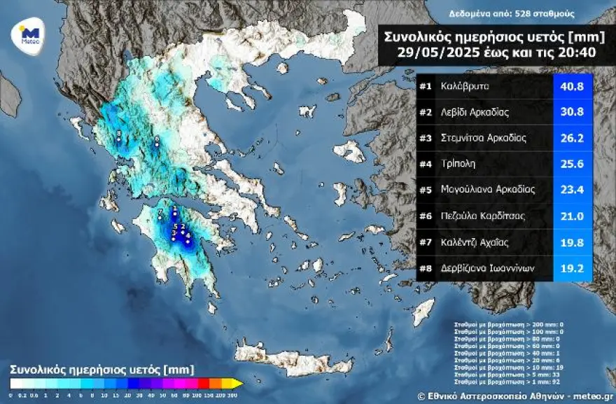
Yesterday, the highest recorded rainfall occurred in Kalavryta, with 40.8 mm by 20:40, followed by Levidi and Stemnitsa in Arcadia. These figures underscore the ongoing wet conditions, especially across mainland Greece, as captured by the network of automated meteorological stations of meteo.gr and the National Observatory of Athens.
Today’s Weather Outlook
– Precipitation: Showers and thunderstorms are expected across the country, with particularly heavy and locally intense storms in Crete during the afternoon. Activity will gradually ease after the peak hours.
– Temperatures: In Western Macedonia, temperatures will range between 11°C and 21°C. Elsewhere, values will vary from 12°C in Sterea and Peloponnese to 28°C in Epirus, with coastal areas experiencing highs around 24-27°C.
– Winds: Northerly winds in the Aegean will blow at 3-5 Beaufort, occasionally rising to 6 Beaufort during the afternoon in the Ionian Sea.
– Regional Highlights: Attica will see clouds with possible localized rain, with temperatures between 18°C and 26°C. Thessaloniki faces similar conditions, with temperatures expected between 18°C and 27°C and intermittent rain or thunderstorms.
Weekend Forecast
– Saturday (May 31): Expect partly cloudy skies with increasing clouds in mainland areas from midday, bringing local rain and isolated thunderstorms, especially in the mountains. Crete and the southern islands may experience intense thunderstorms in the morning. Winds will be predominantly from the north at 3-7 Beaufort, with the highest gusts in the Aegean.
– Sunday (June 1): Cloud cover will persist over Crete with isolated thunderstorms. Elsewhere, the weather will improve gradually, with only localized showers expected in central and southern Greece. Temperatures will remain stable, with slight increases forecasted on Monday.
Next Week Outlook
– Monday (June 2): Expect generally clear conditions, with some midday clouds and isolated mountain rain. Temperatures will rise slightly, signaling the start of summer.
– Tuesday (June 3): Continued fair weather, with minimal cloud cover and a slight increase in temperatures. A few local mountain showers remain possible.
Greece is currently navigating a brief but intense atmospheric disturbance, characterized by thunderstorms, hail, and heavy rainfall, particularly on the mainland and the southern islands. While the weather will ease by the start of next week, residents are advised to stay alert, especially during peak instability hours. The upcoming days will transition from stormy to warm and summer-like, promising more stable conditions and higher temperatures.
Ask me anything
Explore related questions