Greece will enter a 48-hour bad weather spell, with rain, thunderstorms, hail, and lightning affecting many areas of the country. According to the latest weather forecasts, a lot of showers are expected over the Friday-Saturday weekend.
The instability will intensify significantly with several storms, possibly strong, mainly in Halkidiki, Sporades, Magnesia, Evia, Epirus, western and northern Aegean, Sterea, and Peloponnese.
.
From Sunday, the weather will improve, with the rains stopping, but the north wind will strengthen and the temperature will drop.
According to Thodoris Kolydas, temperatures until Friday will be at most 34 to 36 on the mainland, while Friday and Saturday showers will hit in the afternoon and afternoon.
At the weekend, the temperature drops by 3 to 5 degrees and returns to normal levels, while as noted the winds until Friday will be 5 to 6 Beaufort in the Aegean Sea, but on Saturday will reach 6 to 7 Beaufort and on Sunday even 8 Beaufort.
Winds are expected to ease from Monday.
Marousakis warns of storms – Express – The 6 dangerous areas
So the weather scene changes abruptly from Friday, as the unbearable 38°C heat gives way to storms, hail, and gusty north winds. The approaching “cold lake” is expected to cause dangerous conditions, with six areas on a high level of warning, Klearhos Marousakis warns.
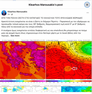
Marousakis’ post
“Intense heat is expected to be the two days Thursday-Friday with the mercury approaching locally even 38° degrees, a temperature value of 5° to 6° degrees above the normal for the season levels.
But the continuation is expected to be completely different and dangerous, we could say, since a cold lake, as we note in the second map with the white arrow from the region of Italy, will create intense instability for 48 hours in many geographical areas of our country.
What is ‘Cold Lake?’
In some cases, the atmospheric circulation that prevails over a geographical area leads to a cut-off of colder gas masses, resulting in the formation of a closed, almost circular area that shows lower temperatures than the surrounding areas.
This phenomenon is observed high in the troposphere and is studied at specific isobaric levels by meteorologists (500 hPa –> 5.5 km altitude, 850 hPa –> 1.5 km altitude, etc.).
where hpa = pascal*100 = ectopascal
‘Cold lake’ weather is characterized by strong instability. In other words, where the sun prevails, it is cloudy and phenomena occur for a few hours, and then the weather opens up to close again, possibly later.
We don’t have the weather of a barometric low or, better yet, an organized barometric low that we expect to pass, so we figure out when it will pass to give the phenomena and then go into improvement, etc.
The phenomena can occur at any time during the day, and it is difficult to pinpoint these intervals accurately.
It is not a barometric low; the occurrence of these phenomena is directly dependent on the amounts of heat accumulated down low, combined with topography.
The rule of thumb is that on land these phenomena develop and evolve between early afternoon and early evening, and in marine coastal areas, between early evening and early morning, although this is not absolute.
This is due to the different ability to absorb and release respective amounts of heat by land and sea, or more scientifically, due to the different heat capacities they exhibit.
VOLUME – TYPE OF PHENOMENA
This depends on the temperature differences that the air masses will experience at altitude, as well as the wind field.
Due to the season we are in, these phenomena often show high intensity, accompanied by intense lightning and even hail.
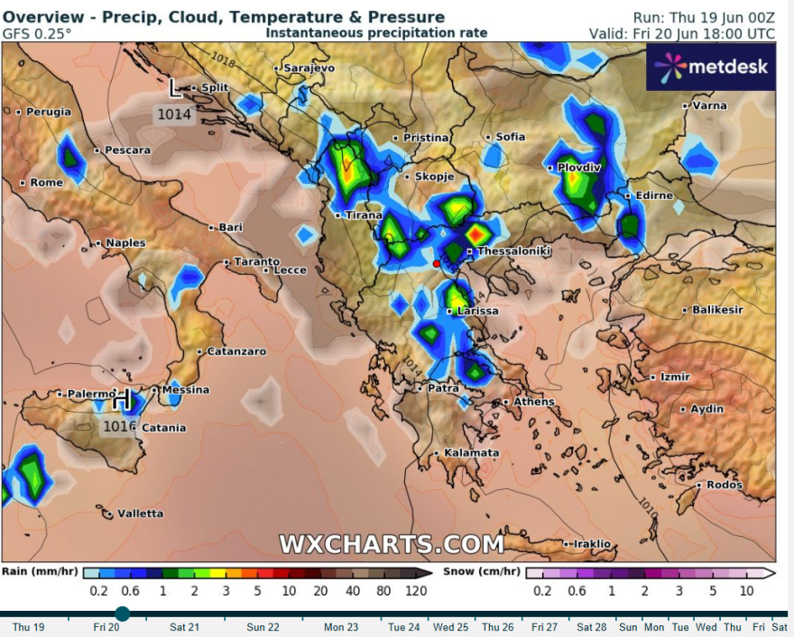
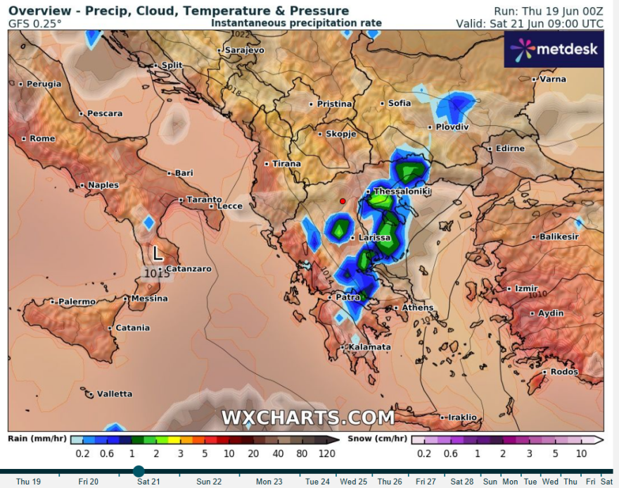
The forecast system puts Macedonia, Epirus, Thessaly, the western and northern Aegean Sea, and a large part of the Peloponnese at very high risk.
When this disturbance completes its action near Sunday, a large pressure differential will build up towards the Aegean Sea, at which point the northerly winds will strengthen to storm levels.
This will cool us down quite a bit, but will significantly increase the risk of fire!
The maps below show what we have analysed with the help of our forecasting system.”
Ask me anything
Explore related questions