
Greece is on the brink of a new and quite intense heatwave, with forecasts showing that starting Monday and for several days, temperatures will soar above 40°C.
The outlook is rather grim, as local temperatures may reach between 42°C and 44°C. Even nights will be difficult, with temperatures remaining high, possibly reaching up to 30°C.
What Meteorologists Say
Meteorologists emphasize both the high temperatures and the long duration of the heatwave, which is expected to be the most intense of the year so far.
Meteorologist Thodoris Kolydas, in a post titled “A heatwave at the gates, with some reservations”, notes that although forecast models agree on the arrival of hot air masses from Africa, current data isn’t yet mature enough to trigger official operational warnings.
He concludes:
“Public trust in forecasts is not built through exaggerations, but through reliable, measured, and timely assessments based on the latest data.”
Full statement by Kolydas:
“A heatwave is imminent, though with some reservations. All ensemble model forecasts agree on a warm air transfer and high-pressure systems over the Eastern Mediterranean and Greece. The atmospheric setup favoring this heatwave is not just likely — it’s dominant.
We can start discussing exact temperature values with greater confidence from Friday onwards, as there is still uncertainty. The upcoming warm event is likely, but not yet ready for official heatwave-level announcements with operational measures.”
“850 hPa maps are excellent tools to detect thermal trends, but not to incite panic or premature estimates. Meteorologists have a responsibility to inform with clarity and caution when conditions require it.”
Giorgos Tsatrafyllias states that the hottest day is likely to be Tuesday, though more peaks are possible during the week. He expects high temperatures to persist until Saturday, July 26.
Similarly, Klearchos Manousakis points out:
“We are not yet in a position to determine the ceiling of the temperatures or the exact duration of the maximum values.”
He adds that through Sunday, temperatures won’t differ much from recent days and may even slightly drop on Friday–Saturday, especially in central and northern regions.
However, fire risk remains high, especially in the north, where unstable conditions could cause dry thunderstorms, potentially sparking fires via lightning strikes.
Yiannis Kallianos mentions the heatwave will clearly be the strongest one so far this summer—though not unprecedented. He forecasts:
“Temperatures between 42–43°C, and possibly up to 44°C locally, with the heatwave likely lasting 5 days, until Friday, July 25.”
He also clarifies that temperature forecasts for July 22–24 are from medium-range weather models (e.g., ECMWF, GFS, ICON, AIFS, UKMO, ARPEGE) and are less reliable than short-range forecasts. Updates will be provided as new data comes in.
Forecasted Temperatures in Major Cities:
ATHENS
- Fri 18 Jul: 36°C
- Sat 19 Jul: 36°C
- Sun 20 Jul: 38°C
- Mon 21 Jul: 39–40°C
- Tue 22 Jul: 41–42°C
- Wed 23 Jul: 40–41°C
- Thu 24 Jul: 41–42°C
THESSALONIKI
- Fri 18 Jul: 34°C
- Sat 19 Jul: 35°C
- Sun 20 Jul: 36°C
- Mon 21 Jul: 37–38°C
- Tue 22 Jul: 38–39°C
- Wed 23 Jul: 39–40°C
- Thu 24 Jul: 39–40°C
PATRAS
- Fri 18 Jul: 32°C
- Sat 19 Jul: 32°C
- Sun 20 Jul: 34°C
- Mon 21 Jul: 35–36°C
- Tue 22 Jul: 39–40°C
- Wed 23 Jul: 37–38°C
- Thu 24 Jul: 37–38°C
HERAKLION
- Fri 18 Jul: 32°C
- Sat 19 Jul: 31°C
- Sun 20 Jul: 32°C
- Mon 21 Jul: 34–35°C
- Tue 22 Jul: 37–38°C
- Wed 23 Jul: 38–39°C
- Thu 24 Jul: 37–38°C
LARISSA
- Fri 18 Jul: 36°C
- Sat 19 Jul: 36°C
- Sun 20 Jul: 39–40°C
- Mon 21 Jul: 41–42°C
- Tue 22 Jul: 43–44°C
- Wed 23 Jul: 41–42°C
- Thu 24 Jul: 42–43°C
ARGOS–NAFPLIO
- Fri 18 Jul: 38°C
- Sat 19 Jul: 36°C
- Sun 20 Jul: 39°C
- Mon 21 Jul: 39–40°C
- Tue 22 Jul: 41–42°C
- Wed 23 Jul: 41–42°C
- Thu 24 Jul: 42–43°C
LAMIA
- Fri 18 Jul: 36°C
- Sat 19 Jul: 34°C
- Sun 20 Jul: 39°C
- Mon 21 Jul: 41–42°C
- Tue 22 Jul: 43–44°C
- Wed 23 Jul: 41–42°C
- Thu 24 Jul: 41–42°C
Giorgos Tsatrafyllias also posted that the “persistent heat will peak with a strong African heatwave.”
“Forecasts still point to a strong heatwave from July 20 to 24, with the most difficult days on Tuesday (22/7) and Wednesday (23/7), where temperatures may exceed 43–44°C. Relief is expected from Friday, July 25, with milder conditions through the end of the month.”
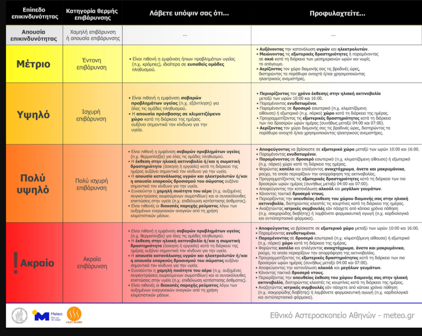
Health Risk for Vulnerable Groups
Prolonged heat exposure, especially without nighttime cooling, greatly increases the risk to human health. Protective measures (e.g., frequent cool showers) are strongly advised for all population groups, especially the vulnerable:
- Elderly
- Outdoor workers
- Children
- Pregnant individuals
- People with chronic illnesses
Today’s Forecast – Thursday, July 18
General Outlook:
Mostly clear skies. Local clouds in Eastern Macedonia and Thrace early morning, and in mainland regions during the afternoon with possible showers or isolated storms in mountainous areas.
Winds:
- North: Northerly winds 3–5 Beaufort
- South: Westerly winds 3–5 Beaufort
Temperatures:
- Northern mainland: 32–34°C
- Rest of mainland: 35–37°C
- Islands: 32–35°C
Regional Highlights:
- Macedonia & Thrace: Cloudy early, with chances of rain/storms later. Temps 19–34°C.
- Ionian Islands & Western Greece: Mostly sunny. Afternoon storms in mountains. Temps 20–36°C.
- Thessaly & Central Greece: Sunny with afternoon mountain storms. Temps up to 37°C, slightly cooler in Thessaly.
- Cyclades & Crete: Sunny, 24–33°C.
- Eastern Aegean & Dodecanese: Mostly sunny, 24–35°C.
- Athens: Sunny, 26–36°C.
- Thessaloniki: Cloudy later with showers/storms, 21–33°C.
Ask me anything
Explore related questions