
The weather this week will follow an autumnal pattern, with two waves of bad weather affecting the country from today until Thursday. Meteorologists are warning of heavy rainfalls, local thunderstorms, and possible hail, mainly in western, southern, and island regions of Greece.
According to forecasts, the first wave will affect the country today and tomorrow, while the second, shorter in duration but with intense phenomena, will arrive on Wednesday, October 22 and Thursday, October 23.
In a post, meteorologist Thodoris Kolydas refers to very beneficial rainfalls, which today will affect the southern Ionian Sea, the Peloponnese, and the southern Aegean. A gradual (but temporary) improvement is expected from Tuesday afternoon, while on Wednesday and Thursday the second wave will arrive, affecting the west, the south, and the eastern Aegean islands (“reverse P weather” – referring to a weather pattern). Weather will improve from Friday, especially over the weekend (a brief “little summer” around the feast of Saint Demetrios), although the forecast for October 28 is still uncertain.
Tsatrafyllias: “It starts with rain and storms, and ends with sunshine and temperatures of 28°C!”
🎯ΠΟΤΙΣΤΙΚΕΣ ΒΡΟΧΕΣ- "Η ΕΥΛΟΓΙΑ ΤΟΥ ΘΕΟΥ"
— Theodoros Kolydas (@KolydasT) October 19, 2025
✅ Πολύ καλές ποτιστικές βροχές σήμερα σε όλα τα κεντρικά και νότια . Οι καταιγίδες από το απόγευμα θα πλησιάσουν στο νότιο Ιόνιο και την Πελοπόννησο και αύριο θα επηρεάσουν και το νότιο Αιγαίο . Σταδιακή βελτίωση -αλλά πρόσκαιρη – από… pic.twitter.com/N2Y0TyNboK
Meteorologist Giorgos Tsatrafyllias, in his own post, breaks down the daily forecast for rain across the country:
- Monday–Tuesday: Peloponnese, Crete, Cyclades, and Dodecanese will see most of the rainfall. Scattered showers or cloudiness expected in other areas. Temperatures will rise.
- Wednesday–Thursday: Rain and scattered storms in the west, south, and eastern Aegean. (“Reverse P” weather pattern again.) Temperatures will rise further.
Friday–Saturday–Sunday–Monday: Sunshine in most areas. Temperatures will reach high levels (above 28°C).
On October 28, Greece’s national holiday, the forecast is currently unreliable.
Warnings and Guidelines
The National Meteorological Service (EMY) has already issued a yellow warning for Central Greece and Evia, where locally heavy rainfall is expected.
Citizens are advised to:
- Avoid unnecessary travel in areas with intense weather,
- Secure loose objects that could be blown away by the wind,
- Be especially cautious when driving, due to slippery roads and reduced visibility.
What to Expect for the Rest of the Week
From Friday onward, the bad weather will subside, and temperatures will rise, mainly in southern and island regions. The weekend is expected to bring generally improved weather, with sunny intervals and mild temperatures.
However, the week will see two intense periods of rain and storms, requiring special caution, especially for residents and drivers in western and southern Greece.
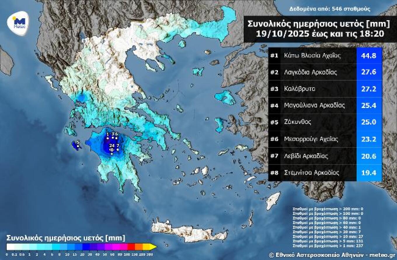
Most Significant Rainfall in the Peloponnese on Sunday
The Peloponnese and the southern Ionian saw the highest rainfall levels on Sunday, October 19, up until 6:20 PM.
A rainfall map (not shown here) displays the distribution of accumulated precipitation up to that time, based on data from the automatic weather station network of meteo.gr / National Observatory of Athens, and also lists the top 8 stations with the highest rainfall levels.
The highest rainfall in the country was recorded in Kato Vlasia, Achaia, measuring 44.8 mm.
Today’s Weather
Cloudy skies are expected across the country, with rain mainly in central and southern regions, and thunderstorms in the Peloponnese, the Cyclades, and from the afternoon in the southern Ionian and western Central Greece.
Temperatures will range:
- Western Macedonia: 4 to 16°C
- Rest of Macedonia & Thrace: 9 to 19°C
- Thessaly: 12 to 19°C
- Epirus: 9 to 21°C
- Central Greece: 12 to 20°C
- Peloponnese: 14 to 21°C
- Ionian Islands: 14 to 22°C
- Northern Aegean: 12 to 20°C
- Rest of the Aegean: 16 to 21°C
- Crete and the Dodecanese: 16 to 25–26°C
Winds will blow from northeast directions at 3 to 5 Beaufort.
- In Attica, cloudy weather with rain is expected. Winds from the northeast at 2 to 4 Beaufort. Temperature: 14 to 19°C.
- In Thessaloniki, cloudy with a few showers. Winds variable, up to 4 Beaufort. Temperature: 12 to 19°C.
Weather for Tuesday, October 21
In the southern mainland, and the southern and eastern Aegean, clouds with rain and scattered thunderstorms are expected. However, weather will gradually improve in most areas, with rain continuing only in the eastern Aegean.
In the rest of the country, there will be scattered clouds, at times denser, with a chance of local showers in mainland areas and overnight in the Ionian.
- Winds:
- West: Variable at 3 to 4 Beaufort
- East: Northeasterly at the same strength
- Temperatures will remain mostly stable, reaching 19 to 21°C in most regions, and 24 to 25°C locally in the Dodecanese and Crete.
Weather for Wednesday, October 22
In the west, increased cloudiness with rain that will intensify from midday, bringing scattered thunderstorms, especially over the Ionian Sea.
In the rest of the country, scattered clouds gradually thickening, with localized rain in mainland regions. There will be favorable conditions for the transport of African dust in the eastern parts of the country.
- Winds: From the south at 3 to 5 Beaufort
- Temperatures: Will rise slightly, mainly in central and northern Greece.
Weather for Thursday, October 23
In the west, Crete, the Cyclades, and the eastern Aegean, clouds with rain and isolated thunderstorms, weakening in the west from midday.
In the rest of the country, unstable weather with partly to mostly cloudy skies and light, local showers.
- Winds: From the south at 3 to 5 Beaufort
- Temperatures: No significant change.
Weather for Friday, October 24
Partly cloudy, locally more dense, with a chance of isolated showers in the eastern Aegean. Visibility will be locally limited during morning hours.
- Winds:
- From the south at 3 to 4 Beaufort,
- In the Aegean, up to 5 or locally 6 Beaufort
- Temperatures: Will rise slightly.
Ask me anything
Explore related questions


