
Strong, localized rains and thunderstorms are expected from the early hours until tomorrow morning (23/10), according to the latest forecast data from meteo.gr / National Observatory of Athens.
The phenomena will initially affect the Ionian and Epirus. From noon until the night of Wednesday 22/10 into Thursday 23/10, strong rains and thunderstorms are expected mainly in the southern Ionian, Epirus, and western Central Greece.
Subsequently, and until the morning of Thursday 23/10, strong, localized phenomena will mainly be observed in western Central Greece and the northern and western parts of the Peloponnese. It is noted that, according to the data available so far, there is also a possibility of strong, localized phenomena in the Eastern Aegean islands on Thursday noon and afternoon (23/10).
According to the categorization of rainfall episodes (Regional Precipitation Index), which is applied by the Meteo unit of the National Observatory of Athens, the rainfall episode for Wednesday 22/10 is classified as Category 3 (Significant).
In the relevant maps, the expected rainfall and wind are presented for (1) the morning and (2) the early evening hours of Wednesday 22/10.
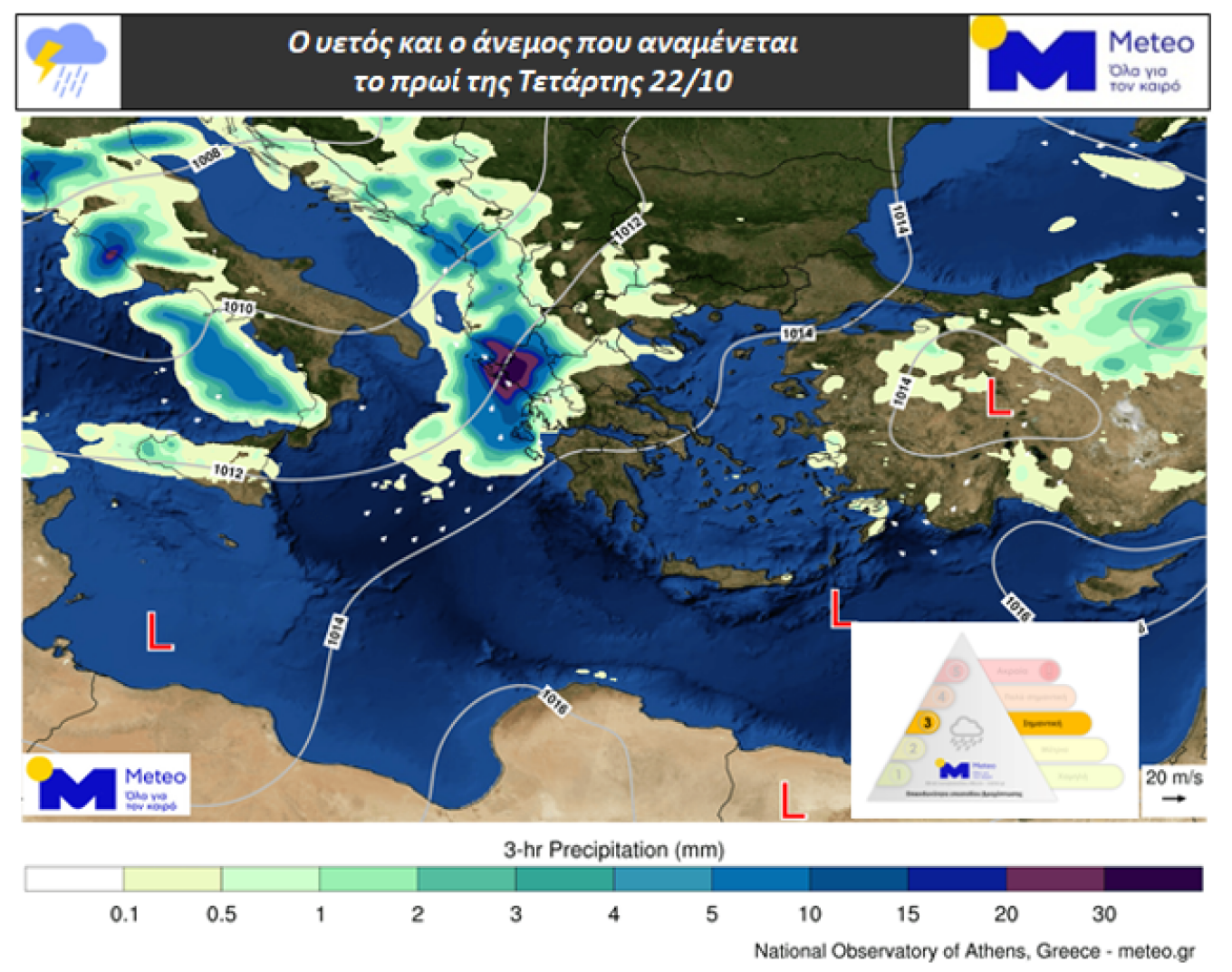
Map 1. Rainfall and wind expected on the morning of Wednesday 22/10
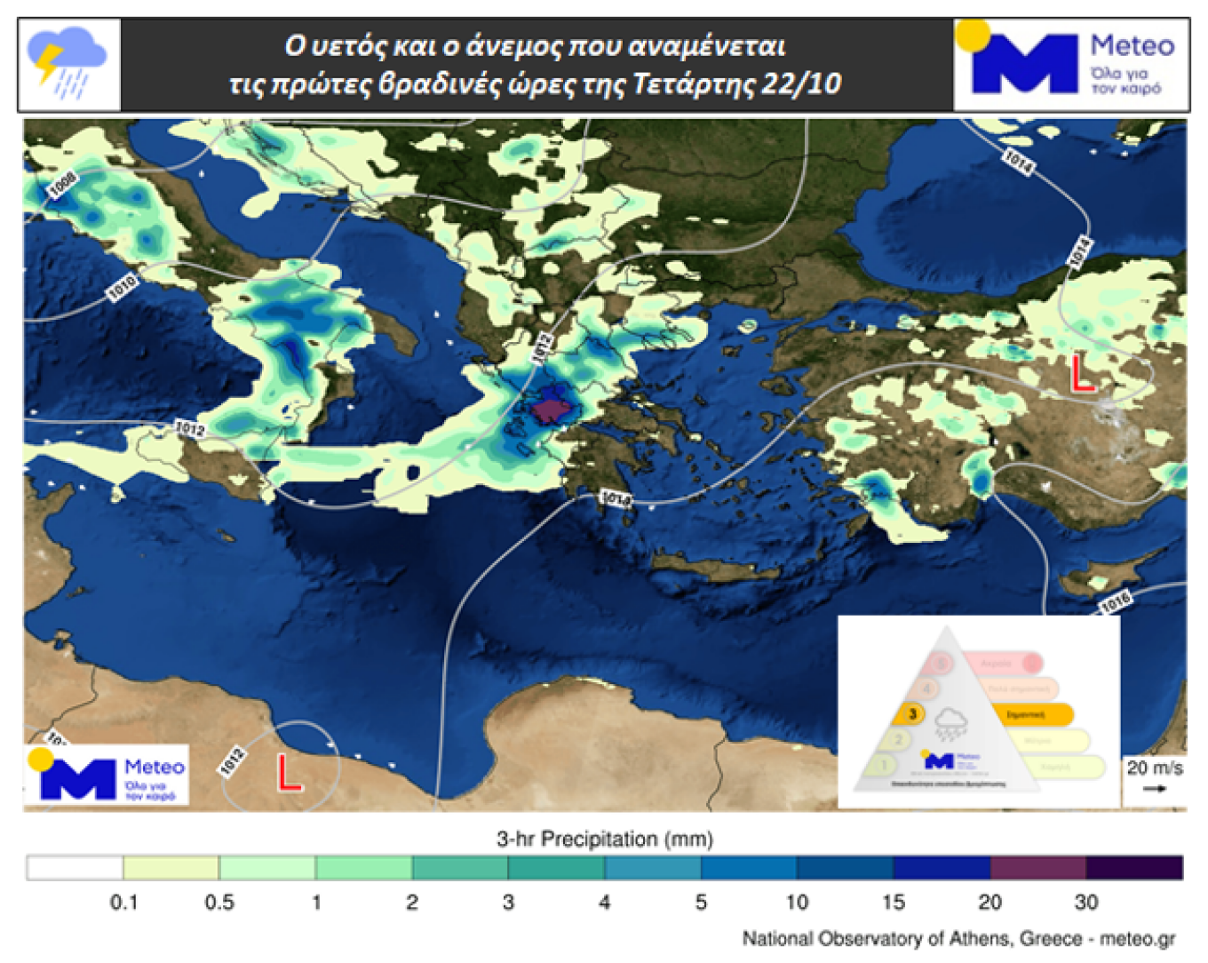
Map 2. Rainfall and wind expected in the early evening hours of Wednesday 22/10
Rain will continue until Thursday, mainly in the west, the south, and the eastern Aegean, according to a post by meteorologist Theodoros Kolydas.
Weather today
Initially, rains and thunderstorms, locally strong, are expected in the Ionian and Epirus. From noon, strong phenomena are expected mainly in the southern Ionian, Epirus, and western Central Greece. Local rains are also expected in Macedonia, the Dodecanese, and from noon in Thessaly, Central Greece, and northwestern Peloponnese. Dust concentrations in the western, southern, and eastern parts of the country will be relatively elevated.
Temperature in Western Macedonia will range from 10 to 15°C, in the rest of Macedonia and Thrace from 9 to 21°C, in Thessaly from 12 to 20°C, in Epirus from 11 to 18°C, in Central Greece and the Peloponnese from 9 to 24°C, in the Ionian Islands from 17 to 20°C, in the Northern and Eastern Aegean Islands from 12 to 21°C, in the Cyclades from 13 to 23°C, in the Dodecanese from 19 to 23°C, and in Crete from 14 to 25°C.
Winds in the Central and Northern Aegean will blow from southern directions at 2 to 4 Beaufort. In the Southern Aegean, winds will blow from southwesterly to westerly directions at 2 to 4 Beaufort. In the Ionian, winds will blow from southern directions at 3 to 5 Beaufort.
In Attica, clouds are expected. Winds will blow from southwesterly directions up to 3 Beaufort. The temperature in central Athens will range from 17 to 20°C.
In the Thessaloniki region, clouds with temporary, local rains are expected. Winds will blow from variable directions up to 3 Beaufort. The temperature in central Thessaloniki will range from 15 to 19°C.
Weather on Thursday, October 23
In the west, the Cyclades, the eastern and temporarily the northern Aegean, clouds with rain and scattered thunderstorms. Weakening of phenomena from the afternoon hours. In the rest of the country, clouds locally increased with local rains and improvement from the afternoon.
Winds will blow south to southwesterly at 3 to 5 Beaufort and in the Aegean locally 6 Beaufort.
Temperature will show a slight rise. It will reach 20–22°C and locally 23°C in the west and north, 23–24°C in the rest of the areas, and locally 25°C in the Dodecanese and Crete.
Weather on Friday, October 24
In the Ionian, western mainland, eastern Aegean, and Dodecanese, clouds locally increased with a chance of local rains. In the rest of the country, light clouds at intervals. Visibility will be locally limited in the morning and evening hours.
Winds will blow from southern directions at 3 to 4 Beaufort and in the Aegean 5 to 6 Beaufort.
Temperature will slightly rise across the country.
Weather on Saturday, October 25
In Thrace, the eastern Aegean, the Cyclades, and Crete, clouds increased at intervals with a chance of a few local rains in the eastern Aegean. In the rest of the country, a few passing clouds. Visibility will be locally limited in the morning hours.
Winds will blow from west-southwesterly directions at 3 to 4 Beaufort and in the Aegean locally 5 to 6 Beaufort.
Temperature will not show significant change.
Weather on Sunday, October 26
In the Ionian, western, and northern mainland, increased clouds with local rains and possibly isolated thunderstorms. In the rest of the country, a few passing clouds.
Winds will blow south to southwesterly at 4 to 6 Beaufort and in the Aegean locally 7 Beaufort.
Temperature will rise.
Ask me anything
Explore related questions