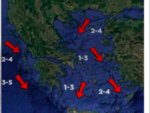
Showers and thunderstorms were recorded today across western Greece — particularly heavy in Zakynthos, Kefalonia, and western Peloponnese — and are expected to move gradually eastward on Thursday, affecting the central, southern, and eastern Aegean as well as the Dodecanese.
According to meteorologist Theodoros Kolydas, unsettled conditions will persist on Friday in the western parts of the country and the eastern Aegean, while the weather is expected to improve over the weekend across most regions. A new deterioration is forecast from Tuesday, starting in the north.
Kolydas noted that temperatures will remain stable until Saturday, then rise significantly on Sunday and Monday, reaching 26–27°C, and locally up to 29°C in northern Crete due to southerly winds. A marked drop in temperature is expected on Tuesday with the passage of a Balkan cold front.
✅Πολλές βροχές και καταιγίδες σήμερα στα δυτικά (ισχυρές σε Ζάκυνθο Κεφαλονιά, δυτ. Πελ/σο) που βαθμιαία αύριο θα επεκταθούν ανατολικότερα επηρεάζοντας τα κεντρικά τα νότια και το ανατολικό Αιγαίο και τα Δωδεκάνησα. Την Παρασκευή θα διατηρηθεί ο άστατος καιρός στα Δυτικά και το… pic.twitter.com/ycrEaqHEJn
— Theodoros Kolydas (@KolydasT) October 22, 2025
Thursday’s Forecast – National Weather Service
Western Greece, Cyclades, Eastern Aegean:
Clouds with showers and occasional thunderstorms. Storms will be locally strong in the Cyclades until midday and in the eastern Aegean islands until late afternoon. Elsewhere, scattered clouds with local showers or isolated thunderstorms.
Visibility will be locally limited in the morning and evening, with fog forming in parts of the mainland.
Winds: Southerly, 3–5 Beaufort; in the Aegean, locally up to 6 Beaufort.
Temperature: 22°C in the west and north, 23–24°C elsewhere, up to 25°C in the Dodecanese.
Regional Forecasts
Macedonia & Thrace:
Gradual weakening of phenomena in the afternoon.
Temperature: 10–22°C (2–3°C lower in western Macedonia).
Ionian Islands, Epirus, Western Sterea, Western Peloponnese:
Rain and storms are easing by noon.
Temperature: 13–22°C.
Thessaly, Eastern Sterea, Evia, Eastern Peloponnese:
Southerly winds 3–4 Beaufort, locally 5 Beaufort in the east and south.
Temperature: 13–24°C.
Cyclades & Crete:
Partly cloudy, occasionally denser clouds with possible light rain in western Crete.
Winds: South to southwest, 4–6 Beaufort in the Cyclades; 3–5 Beaufort in Crete.
Temperature: 16–24°C (locally higher in Crete).
Eastern Aegean Islands & Dodecanese:
Intermittent clouds with local showers, mainly in the Dodecanese.
Temperature: 15–22°C; in the Dodecanese, 18–25°C.
Attica:
Partly cloudy with possible local showers.
Temperature: 15–24°C.
Thessaloniki:
Variable winds 2–3 Beaufort, turning southeast later in the day.
Temperature: 16–22°C.
Ask me anything
Explore related questions


