Springlike conditions will prevail through Monday, but on Tuesday, October 28, temperatures are expected to drop and rain will appear, affecting the scheduled parades and celebrations.
Meteorologist Giorgos Tsatrafyllias wrote in a post: “Four days of spring with 30°C and a parade with chill and rain…” He noted that the rain that fell mainly over the Cyclades and the eastern Aegean will gradually weaken. At the same time, warm air masses are being transported into Greece from southern latitudes, leading to a steady temperature rise through Monday.
Downslope winds are expected to push thermometers up to 30°C in northern Crete and 28–29°C in eastern Central Greece and the Peloponnese, especially on Monday, October 27, 2025. On the 28th, temperatures will drop by about 8 degrees, and rain will occur mainly over the Aegean and the northern and eastern mainland.
Μετά το πέρασμα του ψυχρού μετώπου από τα Βόρεια προς τα Νοτιοανατολικά τη Δευτέρα προς Τρίτη ο καιρός θα παρουσιάσει βελτίωση στις περισσότερες περιοχές. Η παρέλαση θα γίνει χωρίς προβλήματα. #28η_Οκτωβρίου pic.twitter.com/v8TsGZ8a1w
— Theodoros Kolydas (@KolydasT) October 23, 2025
Meteorologist Thodoris Kolydas stated in his post that after the cold front moves from the north toward the southeast between Monday and Tuesday, weather conditions will improve across most regions, allowing the parades to take place without major problems.
Significant Rainfall and Thunderstorms on Thursday
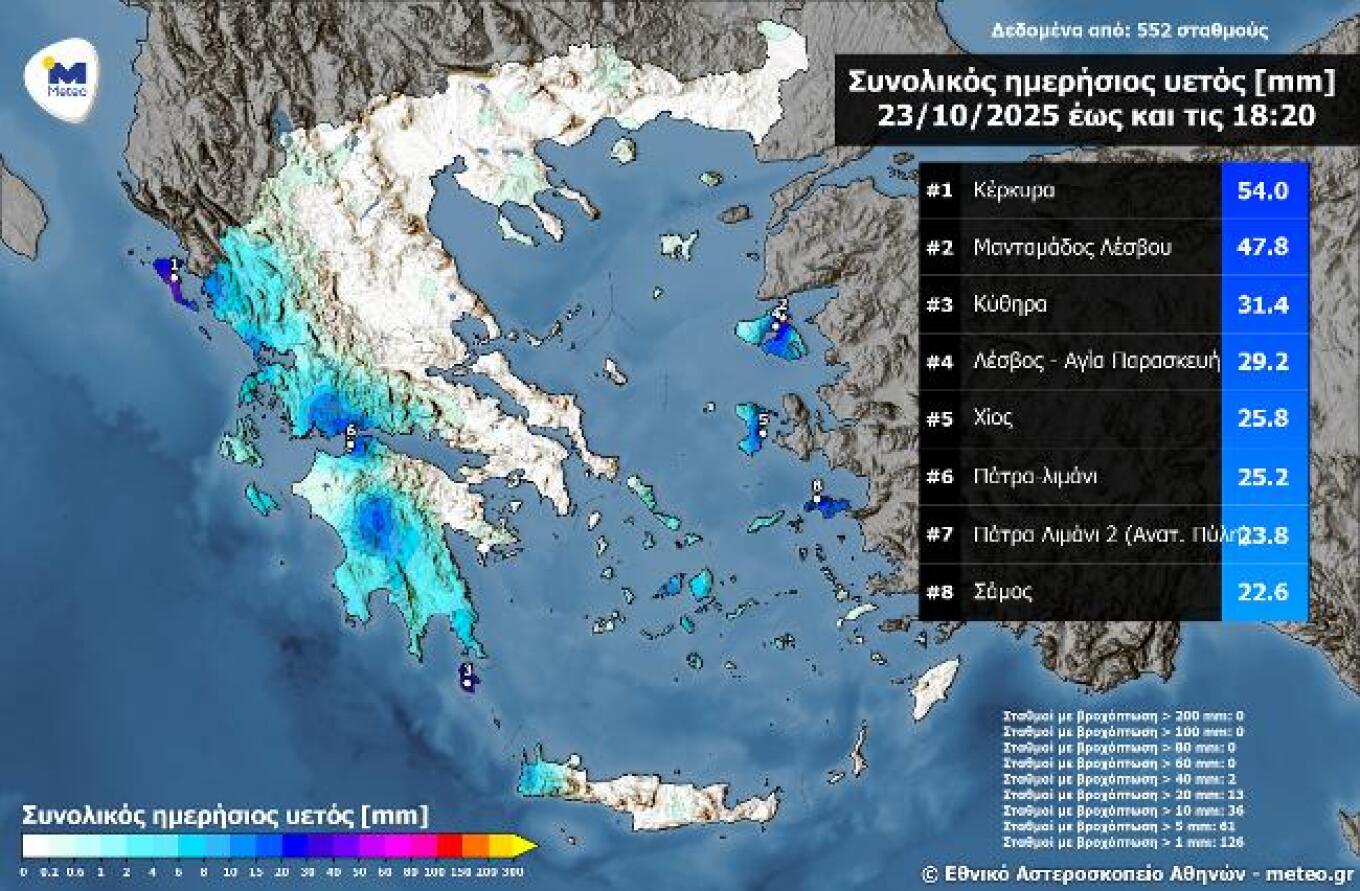
Heavy rainfall was recorded on Thursday, October 23, mainly in western Greece, the Peloponnese, and the eastern Aegean islands. According to the network of automatic weather stations of meteo.gr / National Observatory of Athens, the highest amount of rain by 18:20 was recorded in Corfu, reaching 54 millimeters.
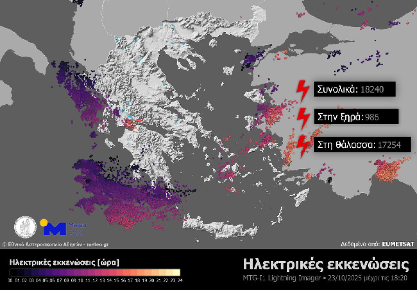
A large number of thunderstorms and lightning discharges were also detected, mainly in marine, island, and coastal areas. According to data from the Lightning Imager (LI) instrument on the Meteosat-12 meteorological satellite, between midnight and 18:10 local time, 986 lightning strikes occurred over land and 17,254 over the sea. These include cloud-to-ground, cloud-to-cloud, and cloud-to-air discharges.
The accompanying maps show (1) rainfall distribution and the eight stations with the highest recorded totals up to 18:20 on Thursday, October 23, and (2) lightning activity recorded by the LI instrument up to the same time.
Weather Today
Intervals of cloudiness are expected. Local rain and possibly isolated thunderstorms will occur mainly in the Ionian Sea, western mainland, the Peloponnese, Thrace, and eastern Aegean regions, possibly extending to the Cyclades and Crete. Dust concentrations will remain relatively high over Crete and the eastern parts of the country but will gradually decrease.
Temperatures will range from 8°C to 22°C in Western Macedonia, 12°C to 25°C in the rest of Macedonia and Thrace, 13°C to 28°C in Thessaly, 15°C to 21°C in Epirus, 12°C to 26°C in Central Greece and the Peloponnese, 19°C to 22°C in the Ionian Islands, 16°C to 23°C in the northern and eastern Aegean islands, 18°C to 24°C in the Cyclades, 18°C to 25°C in the Dodecanese, and 13°C to 27°C in Crete.
In the Aegean, winds will blow initially from the south at 3–5 Beaufort, gradually turning westward by afternoon. In the Ionian, winds will also shift from the south to northwest at similar strength.
In Attica, intermittent clouds are expected. Winds will blow southwest at 2–4 Beaufort, turning northwest later in the day. Temperatures in central Athens will range from 18°C to 26°C.
In Thessaloniki, intervals of cloudiness are also forecast. Winds will be variable up to 3 Beaufort, and temperatures will range from 17°C to 24°C.
Weather on Saturday, October 25
Mostly clear skies will prevail across most of the country, with occasional clouds, temporarily thicker over the eastern islands until noon and from the afternoon in northwestern areas, where light local showers are possible. Morning and evening visibility will be locally limited in mountainous areas.
Winds will blow from the west at 3–5 Beaufort and locally up to 6 Beaufort in the southern Aegean. Temperatures will dip slightly, especially in the north, reaching 22–23°C in the Ionian and western mainland, 23–24°C elsewhere, and up to 25°C in Crete and the Dodecanese.
Weather on Sunday, October 26
Generally fair weather with occasional clouds, temporarily thicker over western and northern mainland areas, where light rain may occur in the northwest. Winds will blow from the west at 3–5 Beaufort, gradually turning southward up to 6 Beaufort from midday. Temperatures will rise slightly.
Weather on Monday, October 27
In the northern Ionian, Epirus, and western Central Greece, increasing cloudiness will bring local rain, intensifying by afternoon with scattered thunderstorms. Conditions will improve by night. Elsewhere, a few passing clouds are expected. Winds will blow from the south at 4–6 Beaufort, reaching 6–8 in the Aegean. Temperatures will continue to rise.
Weather on Tuesday, October 28
In the eastern islands, clouds with local rain and isolated thunderstorms are expected, improving after midday. In the rest of the country, partly cloudy skies will increase by afternoon, bringing local rain in western and northern mainland regions. Winds will blow from the west at 4–5 Beaufort, up to 6 at sea. Temperatures will drop.
Ask me anything
Explore related questions