
Meteorologists have issued a red alert, as heavy rain and thunderstorms are set to hit a large part of the country from today until Friday, with particularly intense conditions in the Ionian, Epirus, Macedonia, Thrace and the eastern Aegean.
The Hellenic National Meteorological Service (EMY) issued an emergency bulletin for the deterioration of weather due to storm system Adel, which is expected to cause dangerous phenomena and gale-force winds.
⚠️⚠️ΚΑΚΟΚΑΙΡΙΑ ADEL- ΚΑΙΡΙΚΗ ΑΝΑΛΥΣΗ
— Theodoros Kolydas (@KolydasT) November 25, 2025
✅Η κακοκαιρία ADEL βρίσκεται πλέον σε φάση ανάπτυξης και θα κορυφωθεί Πέμπτη 27/11 και Παρασκευή 28/11, όμως ήδη από σήμερα Τρίτη επηρεάζει μεγάλο μέρος της χώρας, ιδιαίτερα τη δυτική Ελλάδα, όπου εκδηλώνονται βροχές και καταιγίδες που… pic.twitter.com/1iGnvRpnPQ
Storm system Adel is currently intensifying and will peak on Thursday and Friday (27–28/11). However, from today, Tuesday, it is already affecting large parts of the country, especially western Greece, where rainfall and thunderstorms are occurring and gradually strengthening, according to Thodoris Kolydas.
The meteorologist warns that this wave of bad weather will affect areas that are already vulnerable and previously hit. He notes that particular caution is required mainly in the western zone (Ionian – Epirus – Western Greece), Macedonia – Thrace and the eastern Aegean.
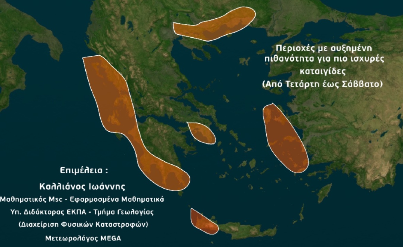
According to meteorologist Giannis Kallianos, based on the data so far, Adel will also affect Attica and Thessaloniki, while there is a real possibility of flooding.
Mr Kallianos states that a strong low-pressure system will affect almost the entire country, causing significant instability and successive rainfall. He warns that there is a risk of flooding until Saturday, 29 November.
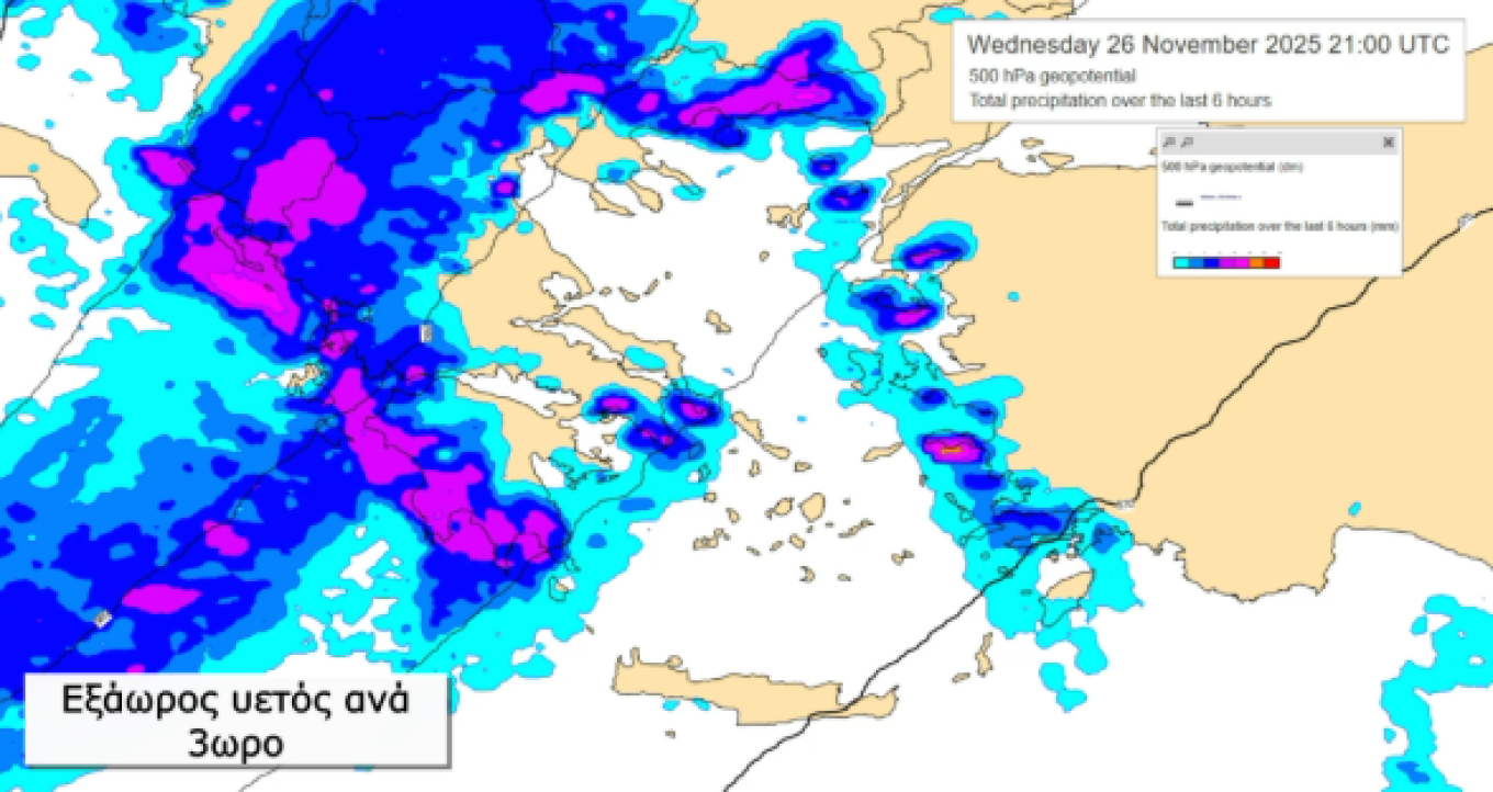
Areas affected on Wednesday
Thodoris Kolydas forecasts heavy rain and thunderstorms on Wednesday:
- Morning to midday: Corfu – Diapontian Islands – Paxos – Epirus
- From afternoon: Lefkada, Kefalonia, Ithaca, Zakynthos, Aetolia-Acarnania, western and southern Peloponnese
- From evening: Eastern Macedonia
Wednesday will be a transitional phase before the peak of the storm, with the western regions experiencing the strongest intensity.
Thursday: The most difficult day
According to Kolydas, Thursday will be the most challenging day, with Adel bringing heavy rain and thunderstorms across much of the country, locally accompanied by hail, very strong winds and significant rainfall totals in already burdened areas.
Areas expected to experience intense phenomena:
- Ionian Islands
- Epirus
- Western and central Central Greece
- Western and southern Peloponnese
- Central and eastern Macedonia
- Thrace
- Eastern Aegean
- Dodecanese
- Cyclades
- Crete
Winds will be southerly at 4–6 Beaufort, locally 7 Beaufort in the Aegean and possibly 8 Beaufort in the Thracian Sea early in the morning.
Strong phenomena on Friday as well
Rain and scattered thunderstorms will occur on Friday across almost the entire country. Strong phenomena will persist early in western Greece, then shift to central and eastern Macedonia, Thrace, the eastern Aegean and locally the northeastern Aegean islands.
Temporary snowfall is expected in mountainous areas of Epirus, Macedonia, Thessaly and western Central Greece. Winds will remain southerly and temperatures will drop slightly.
Kallianos: Heaviest rainfall in the Ionian – Attica also affected
From Wednesday to Saturday, locally strong thunderstorms are expected, with the highest frequency and intensity in western, northern Greece and the eastern Aegean. Winds will strengthen to 6–7 Beaufort, with gusts possibly reaching 8 Beaufort offshore.
The heaviest rainfall is expected in:
- Ionian: 200–250 mm
- Epirus: 150–170 mm
- Western & southern Peloponnese: 160–180 mm
- Eastern Macedonia – Thrace: 200–250 mm
- Eastern Aegean: 200–220 mm
- Attica: 70–90 mm (intermittent storms)
- Thessaloniki: 100–120 mm
Kallianos notes that these figures are preliminary and may change, but are provided for responsible public awareness.
The most intense phase will be Thursday and Friday, although unstable weather and storms may continue until the end of the week. Temperatures will remain slightly above seasonal averages, with gradual improvement from Sunday.
Flood risk areas
Regions with the highest probability of severe rainfall and potential flooding include:
Corfu, Paxos, Lefkada, Ithaca, Kefalonia, Zakynthos, western Thesprotia & Preveza, western Aetolia-Acarnania, western Ilia, Messinia, southern Laconia, eastern Halkidiki, southern Serres, southern Drama, Kavala & Thasos, southern Xanthi, Komotini, Rodopi, Chios, Samos, Ikaria, Kos, western Chania, as well as Attica and Thessaloniki (lower but existing risk).
Other areas may also experience problems, but the above regions are considered top priority for heightened alert and monitoring.
Emergency bulletin by EMY
Heavy rain and thunderstorms currently affecting western and northwestern Greece will intensify in the coming hours, especially in northern Ionian (mainly Corfu) and Epirus.
Wednesday (26/11/25):
- Ionian Islands and Epirus
- From afternoon: Lefkada, Kefalonia, Ithaca, Zakynthos, Aetolia-Acarnania, western & southern Peloponnese
- From evening: Eastern Macedonia
Thursday & Friday (27–28/11/25):
Storm system ADEL will bring heavy rain and thunderstorms, locally with hail and very strong winds, affecting western & northern Greece and the eastern Aegean.
Specifically:
- Thursday: Ionian Islands, Epirus, western & central Central Greece, western & southern Peloponnese, central & eastern Macedonia, Thrace
- Friday: Central & eastern Macedonia, Thrace, eastern Aegean and early morning in western Greece.
Ask me anything
Explore related questions


