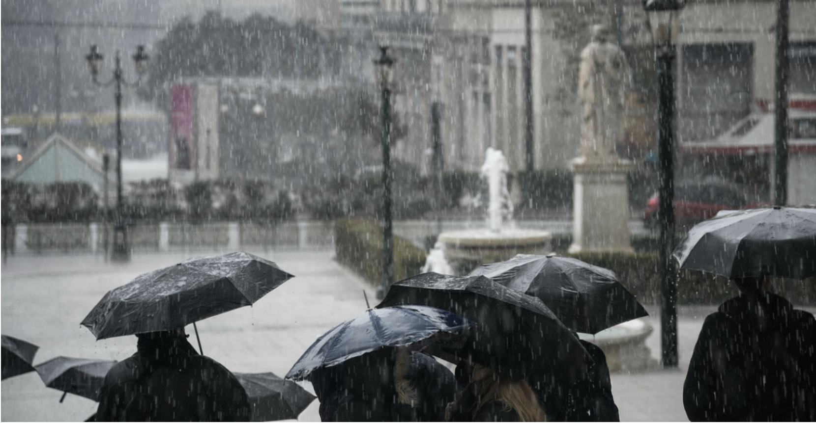
The severe weather system “BYRON,” expected to strike the country starting today, December 4, will bring dangerous weather conditions across eastern and southern Greece, according to the Emergency Bulletin of Dangerous Weather Phenomena issued by the National Meteorological Service (EMY). The intense weather is expected to continue until the early morning hours of Saturday, December 6. The Risk Assessment Committee will meet again at noon (12:00). As a precaution, schools will remain closed today on Symi, Hydra, the Municipality of Troizinia–Methana, and Kythera. On Friday, schools on Kastellorizo will also remain closed.
Citizens are urged to exercise extreme caution during the storm, which is expected to bring very heavy rainfall. Hailstorms are also expected in many parts of the country, with rainfall totals reaching 150–200 millimeters in some areas, meteorologist Giannis Kallianos noted. Special attention is needed in the region of Katerini, where rainfall is expected to be particularly intense.
Attica is also forecast to receive heavy rainfall, with totals reaching 60–70 mm. Civil Protection has placed 8 regions on red alert. These are: Thessaly, Central Macedonia, Central Greece, the Ionian Islands, Crete, the islands of the Eastern Aegean, and the southeastern island regions.
EMY’s Emergency Weather Bulletin
According to the updated Emergency Bulletin of Dangerous Weather Phenomena issued yesterday by the National Meteorological Service (EMY), heavy rain and thunderstorms are expected from today, Thursday (04–12–2025), until the early hours of Saturday (06–12–2025), affecting most of the eastern and southern parts of the country.
The weather system, named “BYRON,” will cause severe weather on Friday (05–12–2025) across much of eastern Greece.
It is also highlighted that the rainfall will be not only intense but long-lasting. In many areas, the severe phenomena will be accompanied by local hailstorms and occasionally very strong winds, which on Friday (05–12–2025) in the southeastern island regions will reach 8, and possibly briefly 9 Beaufort.
More specifically:
A. Thursday (04–12–2025)
Locally heavy rain and thunderstorms are expected:
a. In the Ionian Islands (mainly Kefalonia and Zakynthos)
b. In Central Macedonia (mainly Halkidiki, Pieria, Imathia)
c. In Thessaly (mainly the eastern parts) and the Sporades
d. In Eastern Central Greece (including Attica, especially the southern and eastern parts)
e. In Evia (mainly the southern parts)
f. In the Peloponnese (mainly southern and eastern parts)
g. In the Cyclades
h. In Crete (mainly southern parts)
i. In the Eastern Aegean Islands (from Chios and southward) and the Dodecanese
B. Friday (05–12–2025)
The weather system “BYRON” will cause severe weather across most of eastern Greece.
Heavy rain and thunderstorms are expected:
a. In Central Macedonia
b. In Thessaly and the Sporades
c. In Eastern Central Greece (including Attica) and Evia
d. In eastern and southern Peloponnese
e. In the Cyclades and Crete
f. In the Eastern Aegean Islands (from Chios and southward) and the Dodecanese
The phenomena will at times be extremely intense and potentially dangerous (red warning) in: Pieria – Imathia – Halkidiki – Thessaloniki, Thessaly, the Sporades, Evia, the Eastern Aegean Islands, the Dodecanese, and locally in the Cyclades and Crete.


According to the Rainfall Episode Index (RPI) of the Meteo unit of the National Observatory of Athens, Friday’s (05/12) episode is classified as Category 5 (Extreme).
On Saturday (06–12–2025), the severe weather is expected to weaken from the morning hours and be limited mainly to the Dodecanese.
Citizens can stay informed daily through EMY’s regular weather bulletins and the official EMY website.
Kallianos warns of local flooding
Speaking to protothema.gr, meteorologist Giannis Kallianos explained that Thursday and Friday will be the two most difficult days of the upcoming severe weather, which will last until Saturday.
According to him, this is a weather system expected to affect almost the entire country, with a high likelihood of local flooding.
Caution in Katerini – 60–70 mm of rain in Attica
“There is a high chance we will see over 150 to 200 millimeters of rain,” the meteorologist says, emphasizing that citizens should be particularly cautious in the area around Katerini, while in Attica rainfall of 60 to 70 millimeters is expected.
“We must not walk or drive under trees, we must avoid going near streams, we should not park under trees during the weather event, we must watch out for rising river levels, and we should limit our movements during the intense thunderstorms,” he told protothema.gr.
Meteorologist Thodoris Kolydas noted that the new low-pressure system expected to affect the country is named BYRON and is expected to persist throughout Friday.
This new system arises from atmospheric disturbances and the intense weather conditions expected to hit the country, and he explains why the name was changed.
Today’s weather
Rain will occur in western, central, and southern regions, and gradually in the rest of the country. Sporadic thunderstorms are expected from the morning in the southwest, gradually affecting Crete, the Peloponnese, the Ionian Sea, Central Greece, and from the evening, Thessaly. The phenomena will be locally strong in the southern Ionian, the Peloponnese, Central and Eastern Central Greece, Evia, the Sporades, and Thessaly. African dust transport is expected in western areas.
Temperatures will range:
• Western Macedonia: 3–10°C
• Rest of Macedonia & Thrace: 5–14°C
• Epirus: 9–15°C
• Thessaly: 9–16°C
• Central Greece & Peloponnese: 9–17°C
• Ionian Sea: 14–16°C
• Northern Aegean: 9–15°C
• Rest of Aegean: 13–19°C
• Crete: 14–21°C
Winds:
• Ionian: southeast, quickly turning southwest, 5–7 Beaufort, locally 8.
• Rest of the country: southeast 3–5 Beaufort, up to 6 Beaufort in southern seas.
Attica: Cloudy with rain and thunderstorms. Southeast winds 3–5 Beaufort. Temperature 11–17°C.
Thessaloniki: Cloudy with local rain. Variable winds 3–5 Beaufort, increasing to 6 in the afternoon. Temperature 10–14°C.
Weather on Friday, December 5
Heavy rain and thunderstorms are expected in:
• Central Macedonia
• Thessaly and the Sporades
• Eastern Central Greece (including Attica, mainly southern and eastern parts)
• Evia
• Cyclades
• Crete
• Eastern Aegean Islands (from Chios and southward)
• Dodecanese
• Eastern and southern Peloponnese
The phenomena will be at times particularly strong and potentially dangerous (red warning) in:
Pieria – Imathia – Halkidiki – Thessaloniki, Thessaly, the Sporades, Evia, the Eastern Aegean Islands, the Dodecanese, and locally in the Cyclades and Crete.
Elsewhere, unsettled weather with clouds, local rain, and isolated thunderstorms. Local snowfall in the mountains of central & western Macedonia and Epirus.
Winds:
• East & southeast 4–6 Beaufort, Aegean 7, locally 8.
• In the north by afternoon: east/northeast up to 7 Beaufort.
• West & gradually south: west/northwest 4–5, locally 6 Beaufort.
Temperatures will drop slightly, mainly in the west and north.
Highs: 15–16°C in northern mainland, 17–18°C elsewhere, 19–20°C in Crete, Cyclades, and the Dodecanese.
Weather on Saturday, December 6
In northern mainland, Eastern Aegean Islands, Cyclades, Crete, and the Dodecanese: rain and scattered thunderstorms, locally strong in the early morning.
Elsewhere: cloudy with occasional local showers; isolated storms in western coastal areas. Snowfall in northern mountains.
Winds:
• West: northwest 3–5 Beaufort
• East: south/southeast 4–6 Beaufort, gradually weakening
Temperature: little change.
Weather on Sunday, December 7
Eastern mainland & eastern island regions: increased cloudiness with local rain; isolated storms especially in Crete, the Dodecanese, and the Sporades.
West: a few clouds, temporarily increased, with local rain and isolated storms in the Ionian.
Winds: northerly 3–5 Beaufort, locally 6 in the seas.
Temperature: little change.
Ask me anything
Explore related questions