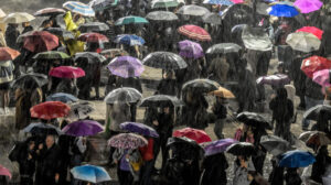
The first week of the year will be marked by strong instability in many parts of Greece, according to official forecasts from the Hellenic National Meteorological Service (EMY) and the assessment of meteorologist Thodoris Kolydas, with phenomena such as heavy rain, thunderstorms, gale-force winds and snowfall in mountainous areas.
EMY has issued an emergency weather bulletin for today, Thursday 8 January, according to which locally heavy rain and thunderstorms are expected in western and northeastern Greece until the morning hours, with gradual weakening thereafter. In the rest of the country, temporarily increased cloud cover with local rain and brief thunderstorms is expected, while late in the evening the phenomena may focus on the eastern and southern parts of the country.
🎯 ✅Η ΠΡΟΟΠΤΙΚΗ ΤΟΥ ΚΑΙΡΟΥ
— Theodoros Kolydas (@KolydasT) January 7, 2026
✅Την Πέμπτη 8/1 ο καιρός θα είναι άστατος, με ισχυρές βροχές και καταιγίδες κυρίως στο Ιόνιο, την Ήπειρο, τη δυτική Στερεά, τη δυτική και νότια Πελοπόννησο, αλλά και στην ανατολική Μακεδονία και τη Θράκη, με βαθμιαία εξασθένηση μέσα στην ημέρα.… pic.twitter.com/waNiMvqhVJ
According to a post by meteorologist Thodoris Kolydas on the weather outlook:
“On Thursday 8/1 the weather will be unstable, with heavy rain and thunderstorms mainly in the Ionian, Epirus, western Central Greece, western and southern Peloponnese, as well as in eastern Macedonia and Thrace, gradually weakening during the day. Phenomena will also affect the eastern–southern Aegean. Snowfall will occur in mountainous areas, temporarily at lower altitudes in the northwest. Winds will be gale-force and temperatures will drop noticeably, with frost at night in the northwest.
On Friday 9/1, phenomena will initially be limited to the eastern and southern Aegean and then improve, while in western Greece local rain will occur from midday. Winds will remain strong but gradually weaken. Further temperature drop and morning frost inland.
On Saturday 10/1, the weather becomes unstable again, with rain and thunderstorms initially in the west and later in many areas of the country. Snow in the mountainous areas of the northwest. Strong winds and a rise in temperature.
On Sunday 11/1, unstable weather persists with rain and thunderstorms, mainly in the west, central–northern regions and the Aegean. Snowfall in mountainous areas and a drop in temperature from the north.”
Problems in Epirus
Adverse weather conditions caused transportation problems, particularly in Epirus. An aircraft that had departed from Athens was unable to land in Ioannina. Upon reaching the Amvrakikos Gulf and due to bad weather conditions, it was forced to return to Eleftherios Venizelos Airport. Dozens of passengers who were planning to travel to Athens were stranded at Ioannina Airport, seeking alternative travel options or overnight accommodation in the city, while several tourists who had planned to continue their journey were also left stranded.
The 112 emergency service issued a warning early on Wednesday evening for intense weather and landslide phenomena until the morning hours of Thursday in Epirus. The National Coordination Center for Operations and Crisis Management issued a “red warning” for severe phenomena, with the most dangerous areas around Louros and Syvota. The Civil Protection Directorate is calling on all involved agencies to remain on high alert and advises citizens to limit their movements and follow safety measures.
Highest rainfall totals from Tuesday 06/01 to Wednesday afternoon 07/01
Heavy rainfall with high precipitation totals has been recorded from the early hours of Tuesday 06/01 until Wednesday afternoon 07/01. According to measurements from the network of automatic meteorological stations of the National Observatory of Athens / meteo.gr, the highest rainfall totals were recorded in the mountainous areas of Epirus, followed by mountainous areas of Thrace and Western Thessaly, regions of Western Macedonia and Lefkada. Image 1 shows the distribution of precipitation across the country, as well as the eight stations with the highest totals.
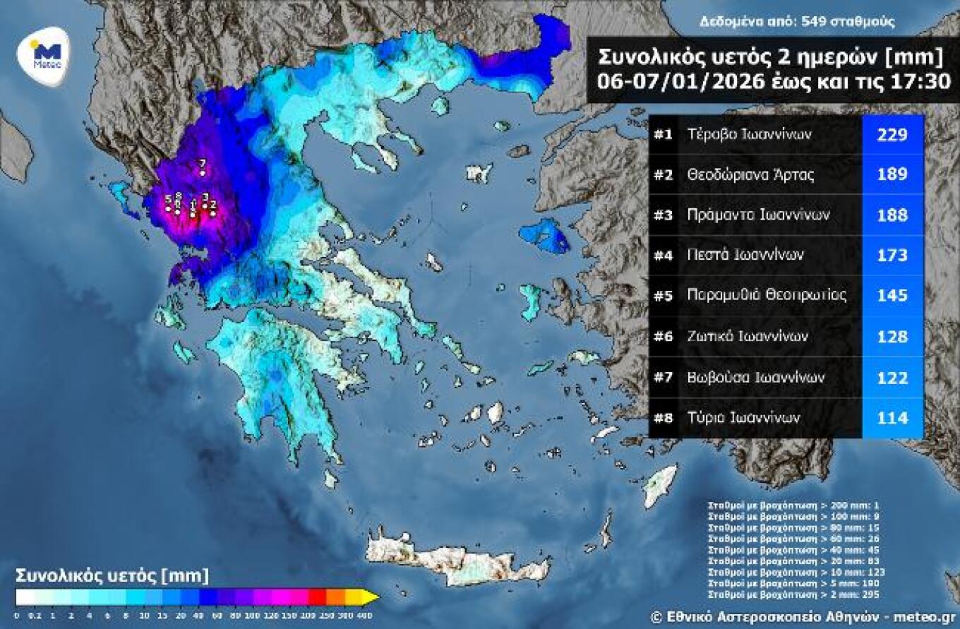
As shown, cumulative rainfall exceeded 200 millimeters in Terovo, Ioannina (229 mm), while more than 100 millimeters were recorded at nine stations.
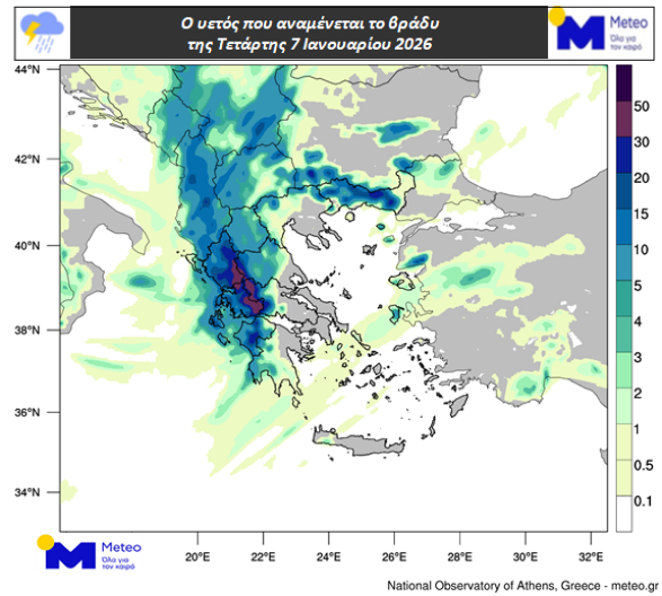
Image 2. Expected rainfall on the night of Wednesday 07/01
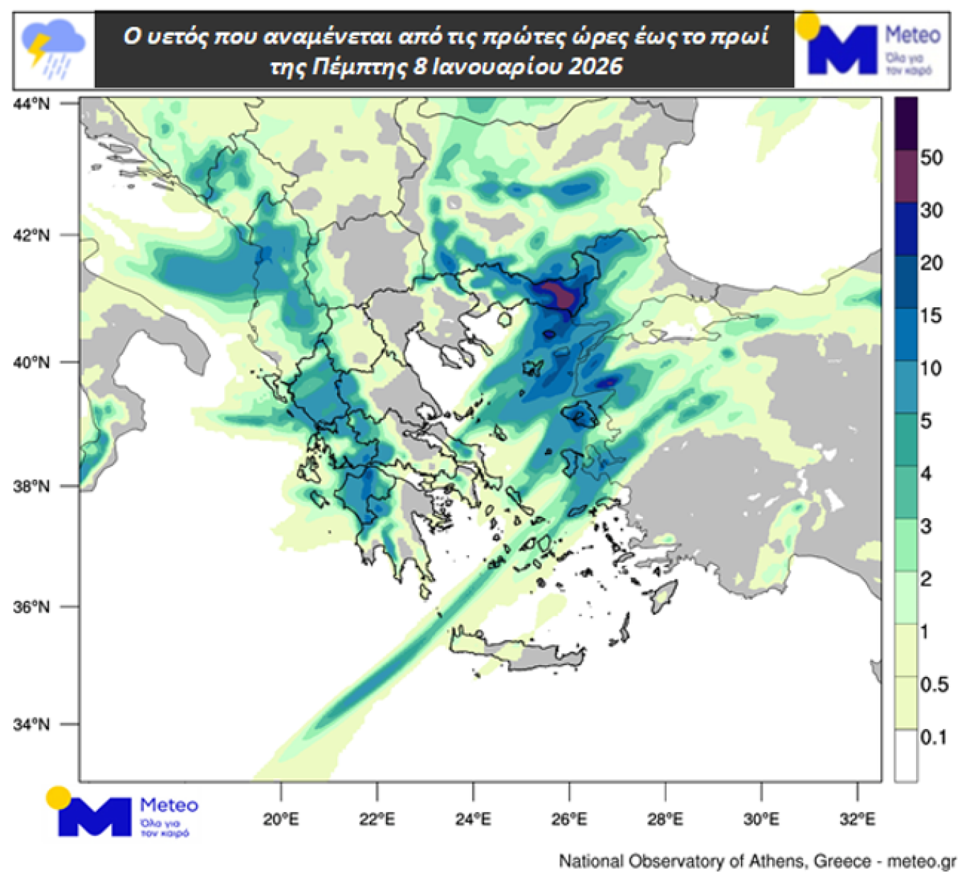
Image 3. Expected rainfall from the early hours until the morning of Thursday 08/01
Weather today
Initially, rain and thunderstorms are expected across the country, but gradually by midday they will weaken and be limited mainly to the west, southwest, north, east and southeast. Dust concentrations in the atmosphere will be elevated in the eastern and southeastern regions until midday.
Temperatures will range from -1 to 7°C in Western Macedonia; from 0 to 16°C in the rest of Macedonia and Thrace; from 3 to 13°C in Thessaly; from 0 to 10°C in Epirus; from 3 to 16°C in Central Greece and the Peloponnese; from 6 to 12°C in the Ionian Islands; from 6 to 16°C in the Northern and Eastern Aegean islands; from 10 to 16°C in the Cyclades; from 13 to 17°C in the Dodecanese; and from 13 to 20°C in Crete. The minimum temperature is expected toward the end of the 24-hour period.
Winds in the Aegean will initially blow from southern directions at 5 to 7 Beaufort, locally up to 8 Beaufort in the eastern parts. From midday they will turn westerly at 5 to 7 Beaufort. In the Ionian, winds will initially blow from westerly directions at 5 to 7 Beaufort, locally up to 8 Beaufort. From the afternoon they will turn northwesterly at 4 to 6 Beaufort.
In Attica, intermittent cloudiness and local rain are expected until the morning. Winds will initially blow from southern directions at 4 to 6 Beaufort, turning westerly of the same intensity from the morning. Temperature in central Athens will range from 8 to 16°C, with the minimum expected toward the end of the day.
In Thessaloniki Prefecture, intermittent cloudiness and local rain are expected until midday. Winds will initially blow from southern directions at 2 to 4 Beaufort, turning westerly at 4 to 6 Beaufort from the early morning hours. Temperature in central Thessaloniki will range from 3 to 14°C, with the minimum expected toward the end of the day.
Weather on Friday 9 January
In the eastern and southern Aegean, increased cloudiness with local rain and isolated thunderstorms in the southeast, with rapid improvement. In the west, few clouds that will gradually increase, with local rain from midday. In the rest of the country, generally fair weather with temporary cloudiness from the afternoon inland.
Winds will blow northwesterly at 5 to 6 Beaufort and in the Aegean 7 locally 8 Beaufort, with rapid weakening in central and northern areas, where from midday they will turn southerly at 4 to 6 Beaufort.
Temperatures will drop further. In northern mainland areas they will not exceed 8–10°C, while in other regions they will reach 12–14°C and locally in the Dodecanese 15–17°C. Early in the morning, frost will occur locally in central and northern mainland areas.
Weather on Saturday 10 January
In the west, the weather will be unstable with local rain and sporadic thunderstorms. In the rest of the country, temporarily increased cloudiness with local rain. Sporadic thunderstorms will occur until the afternoon in northern mainland areas and in the evening in the eastern and southern Aegean. Snowfall will occur in mountainous areas mainly of Epirus and Macedonia.
Winds will blow westerly to southwesterly at 5 to 7 Beaufort and locally up to 8 Beaufort over the seas.
Temperatures will rise, mainly in the eastern regions.
Weather on Sunday 11 January
In western Greece, cloudiness with rain and thunderstorms. In the rest of the country, temporarily increased cloudiness with local rain and thunderstorms mainly in central and northern mainland areas, as well as in the eastern and southern Aegean. Snowfall will occur in mountainous mainland areas.
Winds will blow from westerly directions at 5 to 6 Beaufort and locally up to 7 Beaufort in the southern seas, turning northerly in the north from midday with the same intensity.
Temperatures will drop from the north.
Ask me anything
Explore related questions