The central, old runway becomes the main pedestrian walkway, the former Olympic facilities are key design elements, the sea front is conceptually connected to the interior of the site, and cultural routes are created within the project.
The reason for the Metropolitan Park of Hellinikon as it is described on the basis of the relevant study of the environmental conditions modification file submitted and accompanying the project without, however, “a substantial change in the environmental impact”, as it is noted in this regard.
The reference is to the Metropolitan Park of Hellinikon, as described in the amendment study of the environmental terms submitted for the project, which—according to the documentation—does not entail any “substantial change to environmental impacts.”
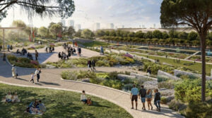
The Metropolitan Park, in its future form, will cover a total area of 2 million square meters. According to the current schedule, its first sections will be delivered gradually during 2026–2027. The landscape architectural design makes use of existing features: the extensive flat surfaces of the site and the existing facilities of both the former airport and the former Olympic venues serve as key sources of inspiration.
“The preserved Saarinen building, the Control Tower, the listed aviation hangars, the runway, and the canoe–kayak facilities are being utilized and given new roles as elements of the Park that express continuity with the past and a connection to the present and future,” the study notes.
According to the Metropolitan Pole master plan, the public transport system will be expanded with a new tram line and three new bus routes within the development area.
Central Design Concept
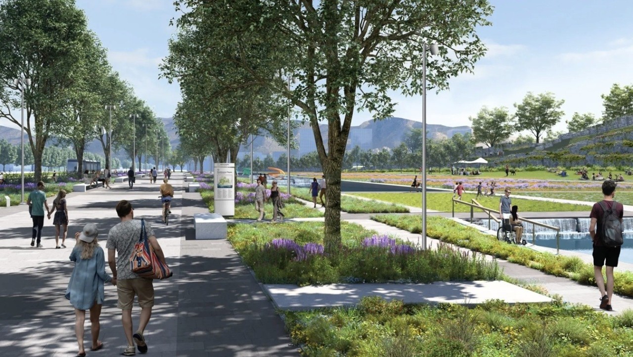
A defining idea of the park is the preservation of the form and memory of the main runway, which will be converted into a pedestrian promenade. The secondary runway that intersects it will be treated similarly. Together with a third, new pedestrian axis linking Vouliagmenis Avenue in the east to the waterfront, they form the Park’s central node—a triangle that includes the existing symbol of the 2004 Olympic Games and a large central square.
Along the new pedestrian promenade flows a dynamic linear water feature. At a second level, perpendicular to the main runway, a winding vehicular route unfolds in a “snake-like” form. According to the study, this design responds to the monotony of the runway’s linear movement, offering constantly changing perspectives while symbolically connecting Mount Hymettus to the Saronic Gulf—mountain to sea.
Landscape Composition
The architectural composition of the new Metropolitan Park includes varied landscape typologies:
- Flat and gently sloping areas
- An artificial hill offering panoramic views
- Depressions, especially in stream areas
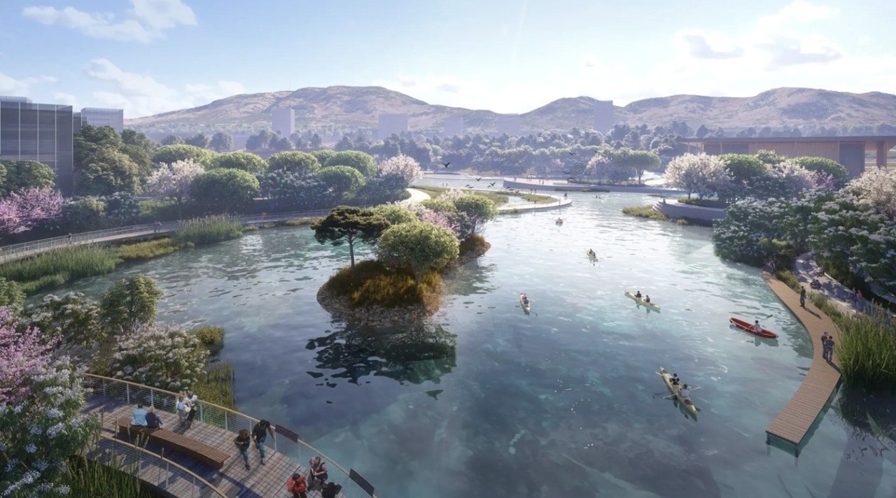
Both the existing Trachones stream and the now “vanished” Airport stream will be restored, contributing to the aesthetic and environmental upgrading of the area.
Cultural Routes
A key objective is the integration of numerous cultural and educational activities operating throughout the day and year. A dedicated cultural route will connect all archaeological and modern monuments within the development, as well as new cultural spaces.
In the northeastern section, the route focuses on the preserved Air Force hangars, which will be restored and operate as museums. From their redesigned outdoor space, two paths emerge:
- One leads to Hassani Hill and then to the restored English hangar (Pagoda), which will host cultural uses.
- The other leads to the classical cemetery and the ancient road at the northeastern edge of the site.
In the northwest section, the route approaches the coast to meet the prehistoric settlement at Cape Agios Kosmas and the Mycenaean tomb. It then passes through residential development areas to ancient remains and a section of an ancient road, finally reaching part of an ancient quarry.
Another path leads to the Hellinikon funerary monument, and another to the former eastern airport terminal designed by Finnish architect Eero Saarinen. All later additions will be removed from the Saarinen building, restoring it as an exhibition venue that can extend into the large open recreational space planned in front of it.
Seven Spatial Units
Seven spatial units organize the park’s functions:
- Aircraft Factory Area (former military base) – 153,828 sq.m.
Historic maintenance hangars will house the new Aviation Museum, alongside new cultural and leisure buildings. Much of the existing soil and hard surfaces will be retained and landscaped. - Sports Area – 511,516 sq.m.
Located at the northwest edge, this will serve as a supra-local sports hub, combining mass participation sports with high-performance training facilities (tracks, football fields, basketball and volleyball courts, indoor gyms, and an Olympic-standard diving pool). It will also incorporate facilities of the National Youth Sports Center of Agios Kosmas. - Trachones Stream Nature & Environment Area – 256,797 sq.m.
Envisioned as a model of sustainable land and water management, featuring a restored stream branch and three new seasonal wetlands. - Olympic Square & Urban Farming Area – 233,961 sq.m.
The “heart” of the park, where main circulation routes converge and Olympic heritage is honored. This area forms the connection axis between the Park and the coastal front. - Hellinikon Sculpture Park – 361,847 sq.m.
A hilly Mediterranean landscape designed to host large-scale sculptures. It includes the Athens–Macedonia Area Control Center building and a wastewater treatment plant serving irrigation needs. - Attic Landscape Area – 55,906 sq.m.
Featuring tree species typical of the Greek landscape, functioning as a transition zone between the Park and surrounding residential areas. - Hellinikon Exhibition Area – 426,714 sq.m.
Following the former airport’s topography, it includes the listed former “Eastern Athens Airport” building (Saarinen building), preserved aircraft movement areas converted for events, thematic gardens, and facilities for urban waste management serving the broader Hellinikon–Agios Kosmas development.
Water, Sewage, Drainage & Firefighting Infrastructure
Water Supply
Potable water will be provided by EYDAP. A new independent water supply network will be constructed and handed over to EYDAP for operation. In the first phase, a twin-chamber underground reservoir of approximately 5,000 m³ will be built. Maximum daily demand is estimated at 15,000 m³, with average daily consumption at 10,500 m³. The pumping station will have a capacity of 1,260 m³/hour.
Urban Wastewater
Urban wastewater will be directed to EYDAP’s central southern collector along Poseidonos Avenue. A Wastewater Treatment Plant (WWTP) will be constructed to produce irrigation water for the Park and other green areas, meeting legal quality standards.
Irrigation
Until the WWTP is completed, irrigation needs will be covered by EYDAP’s water network. After completion, treated wastewater will supply irrigation needs across the Park and development zones.
Stormwater Network
Stormwater within the Park will be primarily collected through surface channels and directed to a trapezoidal ditch along the pedestrian axis. The internal drainage basins are divided into four sections, defined by the Trachones stream, the central pedestrian/tram axis, the main road axis, and the Airport stream. In other areas, stormwater will be collected via roadside drains.
Firefighting
The firefighting network will be supplied from an irrigation reservoir containing treated water from the WWTP.
Ask me anything
Explore related questions