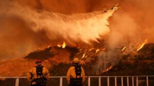
A new warning – the fourth in a row – for a “particularly dangerous situation” that could be caused by weather conditions was issued Tuesday by Los Angeles authorities, as strong winds are set to hit the fire-ravaged area.
The National Weather Service noted that winds of up to 110 kilometers per hour will blow through Wednesday.
This warning comes after three previous ones this season of wildfires that wreaked havoc in the densely populated Los Angeles area, specifically in the Eaton and Palisades neighborhoods.
The warning went into effect at 4 a.m. Tuesday morning (local time) and covers parts of Los Angeles and Ventura counties, where at least 11 people have died and more than 12,000 buildings have been destroyed.
Areas covered by the latest alert include Camarillo, Fillmore, Northridge, Simi Valley and Thousand Oaks.
Fears of another wave of high winds and resurgent fires in the next 48 hours are coming as meteorologists say the unprecedented level of wildfires is due to unseasonably dry conditions.
The last significant rainfall in downtown Los Angeles occurred in May 2024 and since October 1, just 0.16 inches of rain has fallen – compared to the historical average of 5.34 inches, the LA Times reports.
Climatologist Bill Patzert told the medium that “the last nine months have been one of the driest on record since 1900. In my career, I’ve never seen Santa Ana-type events so far exceed the normal winter rainfall season.”
Ask me anything
Explore related questions


