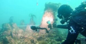
French maritime archaeologists have discovered an impressive underwater structure off the coast of Brittany, dating to around 5,000 BC and considered the largest underwater construction ever found in France. The structure is a stone wall approximately 120 meters long, now submerged under nine meters of water. At the time of its construction, however, it stood along the shoreline, within the tidal zone.
Scientists believe the wall was built either as a fish trap or as a protective dike against the gradual rise in sea levels. When it was constructed, at the western end of Brittany on the island of Île de Sein, the landmass was significantly larger than it is today, having shrunk dramatically over the millennia.
The structure averages 20 meters in width and two meters in height. At regular intervals, divers have identified large upright granite stones—monoliths—protruding in two parallel rows. According to archaeologists, these monoliths were first set into the rocky substrate, after which the wall was built around them using slabs and smaller stones. If the structure functioned as a fish trap, the upright stones likely supported nets made of branches and wood, which would have trapped fish as the tide receded.
With an estimated total mass of 3,300 tons, the wall is believed to have been constructed by a large and well-organized community. Its preservation over approximately 7,000 years suggests it was an exceptionally robust structure. As archaeologist Ivan Payyer explains, it may have been built either by a hunter-gatherer society transitioning toward permanent settlement or by Neolithic populations that arrived in Brittany around 5,000 BC.
The monoliths are reminiscent of the famous menhirs found inland in Brittany today, though they are older. Researchers believe there was a transfer of expertise in quarrying, cutting, and transporting stone between early Mesolithic populations and the Neolithic farmers who followed.
The discovery was made after geologist Yves Fouquet studied underwater depth maps produced using modern radar technology. As he told the French newspaper Le Monde, the linear structure “blocking” an undersea valley could not be a natural formation. Initial dives took place in the summer of 2022, while full mapping was completed the following winter, when marine vegetation had receded.
In a study published in the International Journal of Nautical Archaeology, scientists link the discovery to local Breton legends of sunken cities. One of the best-known is the legend of the lost city of Ys, traditionally believed to have been located in the Bay of Douarnenez, a few kilometers to the east.
As the study suggests, the abandonment of an area developed by a well-organized society—combined with rapid sea-level rise and the loss of fishing and settlement infrastructure—may have left a deep imprint on collective memory, eventually transforming into legend over the centuries.
Ask me anything
Explore related questions


