





Temperatures are expected to rise, with heatwave conditions forecast over the coming days by the National Observatory of Athens and the Hellenic National Meteorological Service (EMY). The heatwave is expected to last through Wednesday, August 26, 2026, with temperatures reaching 40°C in several areas.
According to forecast data from the National Observatory of Athens / meteo.gr, temperatures will rise slightly further across the country over the two-day period of Saturday, August 22, and Sunday, August 23.
Heatwave conditions will prevail in many areas through the middle of next week. Maximum temperatures are expected to reach 38–40°C, while locally they could touch 41–42°C.
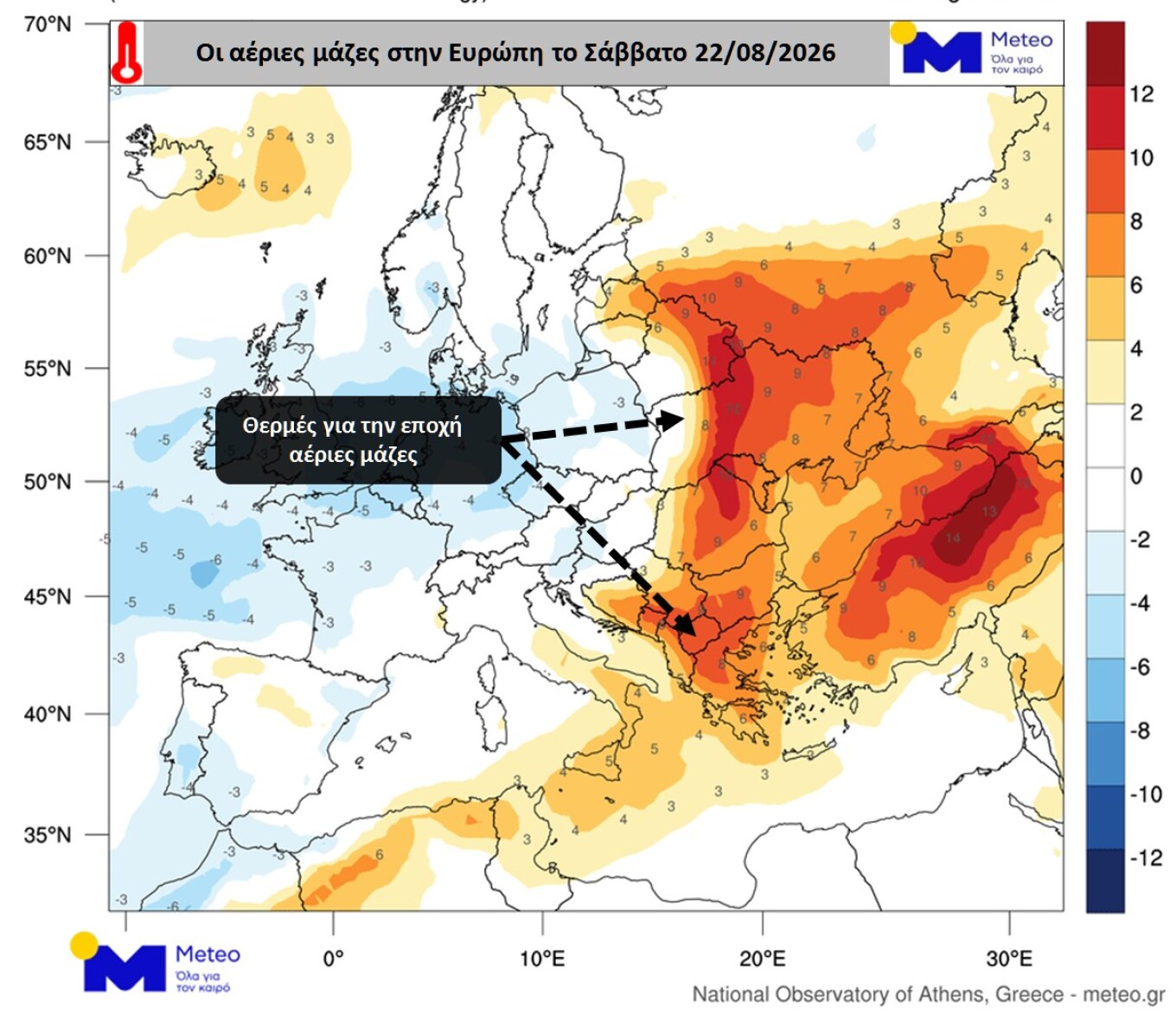
Forecast maps show the temperature anomaly of air masses at an altitude of 1,500 meters above sea level on Saturday, August 22, and Tuesday, August 25. The maps indicate that air masses over Greece will be 6–8°C warmer than normal for this time of year.
The 1,500-meter level is used to study temperature changes in the lower atmosphere. The actual temperature near the ground, however, depends on numerous factors, including the presence or absence of clouds and weather phenomena, wind and the topography of each area.
EMY forecast for Saturday
According to the Hellenic National Meteorological Service forecast for Saturday, August 22, 2026, temperatures will remain above seasonal norms, reaching 38–39°C and locally 40°C on the mainland, while temperatures on the islands will reach 35–37°C.
The weather will generally be clear, with a few temporarily increasing clouds during the afternoon over mountainous mainland areas, where localized rain or showers are possible. Visibility will be locally reduced in the west during the morning.
Winds will be north-northwesterly at 3–5 Beaufort, locally reaching 6 Beaufort in the west and south. Temperatures will rise slightly further, reaching 38–39°C and locally 40°C on the mainland, and 35–37°C on the islands.
Macedonia and Thrace: Generally clear, with a few temporarily increasing clouds in the afternoon and a possibility of localized rain or showers over the mountainous areas of Macedonia. Winds variable at 2–3 Beaufort, with easterly to northeasterly winds of 3–4 Beaufort in the east during the morning. Temperatures will range from 21°C to 38–39°C, reaching locally 40°C in Central Macedonia.
Ionian Islands, Epirus, Western Central Greece and Western Peloponnese: Generally clear, with temporarily increasing clouds over mountainous mainland areas in the afternoon, bringing localized rain or showers. Winds westerly to northwesterly at 4–5 Beaufort, locally 6. Temperatures will range from 23°C to 34°C, reaching locally 35–37°C on the mainland.
Thessaly, Eastern Central Greece, Evia and Eastern Peloponnese: Generally clear, with temporarily increasing clouds over mountainous areas in the afternoon and a possibility of localized rain or showers. Winds variable at 3–4 Beaufort, with southerly winds of up to 4 Beaufort in the south. Temperatures will range from 22°C to 38–39°C, locally reaching 40°C.
Cyclades and Crete: Generally clear, with northerly to northwesterly winds at 4–5 Beaufort, locally 6. Temperatures will range from 24°C to 34°C, reaching 35–36°C in Crete.
Eastern Aegean islands and Dodecanese: Generally clear. Winds northerly to northwesterly at 4–5 Beaufort, locally 6. Temperatures will range from 24°C to 36°C, reaching locally 37°C in the south.
Attica: Generally clear, with a few temporarily increasing clouds in the afternoon. Winds variable at 2–3 Beaufort, with southerly winds of up to 3 Beaufort along the southern coast during the afternoon. Temperatures will range from 23°C to 36–37°C, possibly reaching 38°C locally.
Thessaloniki: Generally clear, with variable winds at 2–3 Beaufort and southerly winds of up to 3 Beaufort along the southern coast during the afternoon. Temperatures will range from 22°C to 36°C.
Little change in the weather on Sunday
On Sunday, August 23, 2026, the weather is expected to remain generally clear, with temporarily increasing cloud cover over mainland areas during the afternoon. Localized rain or showers are expected, with isolated thunderstorms possible over mountainous areas.
Visibility will be locally reduced in the west during the morning. Winds will be northerly to northwesterly at 3–5 Beaufort, locally 6 in the west and south. Temperatures will show no significant change.
Isolated thunderstorms on Monday
Generally clear weather is forecast for Monday, August 24, with temporarily increased cloud cover over mainland areas, particularly mountainous regions, during the afternoon. Localized rain or showers are expected, with isolated thunderstorms possible mainly over northern mountainous areas.
Winds will be northerly: 3–4 Beaufort in the west, locally up to 6 in the northern Ionian, and 4–6 in the east, locally reaching 7 Beaufort in the Aegean.
Temperatures will fall slightly in the maximum values in the eastern windward areas, while remaining largely unchanged elsewhere.
Winds up to 7 Beaufort on Tuesday
Generally clear weather is expected on Tuesday, August 25, with temporarily increasing clouds over mainland areas, mainly mountainous regions, during the afternoon. Localized rain or showers are expected, with isolated thunderstorms possible over northern mountainous areas.
Winds will be northerly at 3–5 Beaufort in the west and 4–6 Beaufort in the east, locally reaching 7 Beaufort in the Aegean.
Temperatures will show no significant change.
Ask me anything
Explore related questions




