

Particularly warm – for the season – is the weather in recent days with the main characteristics of rising temperatures and the transport of African dust.
The African dust is not expected to subside before Tuesday 2 April, while according to meteo.gr, extremely warm for the season air masses are expected in Eastern Europe and our country from Sunday 31 March to Tuesday 2 April. Indicatively, on Monday afternoon the air masses over our country will be up to 15-16 degrees Celsius higher than normal for the season.
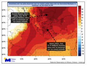
meteo.gr: Unseasonably warm air masses in Eastern Europe and Greece – From Sunday 31/3 to Tuesday 2/4.
According to the latest forecast data of meteo.gr / National Observatory of Athens, the atmospheric circulation over Europe in the coming days will favor the transfer of extremely warm for the season air masses from Africa to Eastern Europe and our country with the peak expected in the three-day period Sunday 31/03 – Tuesday 02/04.
Using the temperature deviation at the 850 hPa isobaric level (about 1500 metres above sea level), the level used to monitor the gas masses, the air masses over parts of Eastern Europe are expected to be up to 17-18 degrees Celsius higher than normal for the season.
As can be seen in the graph below, where we focus on our region, we note that on Monday afternoon 01/04 the air masses over our country will be up to 15-16 degrees Celsius higher than normal for the season. It is worth pointing out that surface temperatures and how high they will reach depends on many factors, such as cloud cover and wind, but with current data the temperature at the beginning of next week is likely to approach or even exceed 30 degrees Celsius in parts of the mainland.
The first wave of African dust is bidding us farewell and we are preparing to welcome the second wave which seems somewhat milder, unless it regrets it and intensifies along the way.
See the simulation from our weather model.
Spring has come to us with wild moods…”.
The weather this weekend
The weather on Saturday 30/3
Generally clear weather with sparse clouds at times. Visibility will be locally limited in the morning and evening hours, with patchy fog in the east. Winds will initially be variable 2 to 4 Beaufort. Gradually from the west, southeast winds will blow south to 5 and in the evening hours in the Ionian Sea locally up to 6 Beaufort. The temperature will remain high for the season and will reach 23 to 25 and locally in the centre 26 degrees Celsius.
The weather on Sunday 31/3
Generally clear weather with sparse clouds at times. Visibility will be locally limited mainly in the eastern maritime and coastal areas where fog will form in the morning and evening hours. Meteorological conditions favour the transport of African dust with low concentrations. Winds will blow from the south at 3 to 5 Beaufort and in the Ionian Sea locally at 6 Beaufort. Temperatures will rise slightly, mainly in the west, and will be very high for the season. It will reach 23 to 25 degrees Celsius in the islands and coastal areas and 25 to 27 degrees Celsius in the rest of the country.
Easter in Greece: 6 destinations for your travel list (photos)
How the weather will develop from next week
The weather on Monday 1/4
Generally clear weather with sparse clouds at times. Visibility will be locally limited mainly in the eastern maritime and coastal areas where fog will form in the morning and evening hours. Meteorological conditions favour the transport of African dust with low concentrations. Winds will blow in the south-east from the west north-west at 3 to 4 Beaufort and in the remaining areas from the south at 3 to 5 Beaufort and in the Ionian Sea locally at 6 Beaufort. Temperatures will rise across the country and in most areas will be 8 to 10 degrees above normal for the season.