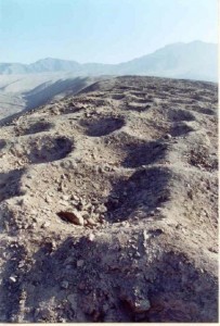
In the Pisco Valley of the Nazca Plateau, in the same area as the well-known Nazca Lines, there is a very mysterious series of holes carved into the rock. Other names for these holes, in Spanish, are Monte Sierpe (Serpent Mountain), or Cerro Viruela (Smallpox Hill). It is a series of approximately 6,000 man-sized holes.
The locals have no idea who made the holes or how they even got there, let alone what they were used for. Some experts have given a few theories for why they appeared, such as for storage places, graves, or defensive positions, maybe even having extraterrestrial origins. The most widely accepted theory is that they were storage pits from the Inca Empire (1438-1533).
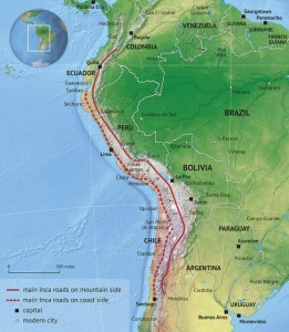
(This map shows the Inca Road System through South America)
The band of Holes extends in a north-south orientation over very uneven terrain, and starts at the edge of a valley and continues up a hill for 1.5km. The holes are almost 1 meter in diameter and range between 50-100cm deep. They have no real pattern in how they were dug, and they are laid out in a band that varies in width from 14-21 meters, with the average width being around 19 meters.
The site was finally brought to light in 1933, when an aviator named Robert Shippee published a photograph in National Geographic.
In 1953, Victor Wolfgang von Hagen surveyed the area, then writing about it in his book The Royal Road of the Inca, he describes the holes as being pre-Inca graves, “These circular, stone-lined, although unused, graves lay in rows, seven to nine, and march up the 50° angle of the slope called Mt. Sierpe, that is the “shaking” line of graves, reminding the one who named it of a serpent.
(Faixa de Buracos – Linhas de Nazca – Peru – Band of Holes)
There are over 5,000 such graves; empty graves in so far as they are circular and stone-lined and of the same construction of those graves found with mummies, weavings and pottery. For years, ever since 1931, they appeared on the photographic plates of the aerial surveys of the Shippee-Johnson expedition. They were the “strange and mysterious pockmarks”, but when discovered and surveyed by the von Hagen expedition in 1953 and found to be unused graves, the mystery was compounded. The Inca engineers would have seen the same phenomena but as in the case of the equally mysterious Nasca lines, they filled in those which interfered with the road and ran over it and through them”.
After that, more archaeologists by the names of Frederic Engel and Dwight Wallace visited the site in the early 1970s.
In his book The Inca Road System, John Hyslop wrote that, “Circular structures, sometimes semi-subterranean, that may have been used for storage, are also found on the Peruvian south coast in the sites Quebrada de la Vaca and at Tambo Colorado.
Hundreds of stone-lined circular holes in rows have been found on a low ridge on the north side of the Pisco Valley.
Although their role has not been determined, a hypothesis for investigation is that they were used for storage. They are between two important Inca sites (Tambo Colorado and Lima la Vieja), and very near the point where the Inca coastal road crosses the road to the highlands. They might be one of the empire’s larger storage sites”.
(Victor von Hagen 1984 at Boggioli, Toscana)
Archaeologists from UCLA made a visit to the site in 2015. They used photography from a drone to create a very detailed map of the holes. The UCLA team speculates that the holes may have been a method of measuring the produce that would be given to the Inca state as a tribute.
They believe that the measurements would have been written on Incan Khipus and then reported to government officials. The UCLA team hopes to return and do more studies to find phytoliths or pollen that could help in confirming their theory.
Ask me anything
Explore related questions


