Α deep low pressure front that formed over southern Italy on Friday is expected to quickly move towards Greece and bring a change in weather in the country, especially on Saturday, the meteo weather service of the Athens National Observatory said.
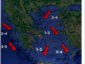
On Friday afternoon, southerly winds will gradually get stronger in the Ionian Sea and the northern Aegean, reaching 8 on the Beaufort scale late at night.
The first heavy rainfall and storms will start affecting the Ionian islands late on Friday and spread to western and central parts of the country during the night. The weather phenomena are forecast to be severe and the danger of flooding high.
In addition, the strong southerly winds will favour the transfer of African dust, with the highest concentrations observed in the southern Aegean and Crete. Muddy rain is also expected to fall on the Greek mainland at intervals.
Temperatures will drop by up to 4-5 on the Celsius scale on Saturday in comparison with Friday.
source amna.gr
Ask me anything
Explore related questions


