The severe weather system called “Barbara” is descending on Greece, according to the National Observatory of Athens / meteo.gr which forecasts a significant drop in temperature during the weekend (04-05/02) while snowfall will occur even at low altitudes in the eastern and southern part of the country.
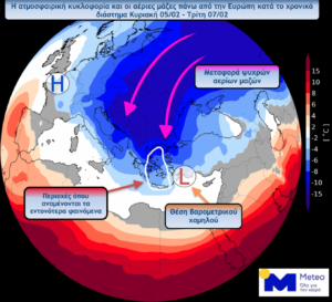
The sudden weather shift is caused due to the atmospheric circulation over Europe in the next few days, which is characterised by the development of a high-pressure area stretching from North West Africa to Scandinavia, combined with the low pressures in Eastern and Southeastern Europe, will allow the transfer of cold gas masses to the Balkans and Greece.
The atmospheric circulation will be characterized by the movement of micro-disturbances in the upper troposphere from the northeast towards our country and which will contribute to the occurrence of significant snowfalls in the east and south of the country.

In more detail during the time period from Sunday 05/02 to Tuesday 07/02, according to meteo.gr the following phenomena are forecast:
– A significant drop in temperature is expected gradually from the evening hours of Saturday from north to south, which will be felt throughout the country until Sunday afternoon. The temperature drop will be around 8-10 and locally 10-12 degrees Celsius.
– Snowfall even in low altitudes (in continental up to lowland parts) is expected to occur mainly in the eastern and southern parts of the country with an emphasis on the Sporades, south-eastern Thessaly, Evia, Boeotia, Attica, Cyclades, Eastern Peloponnese, and Crete. Temporary snowfalls are also likely to occur in parts of Thrace, the islands of the northeastern Aegean, and Halkidiki.
– Strengthening of northerly winds to 7-8 and locally up to 9 Beaufort.
– Strong frost in the north, where in several areas there will be total frost.
– Finally, as the National Observatory of Athens notes, the exact movement and time of arrival in our country of these micro-disturbances in the upper troposphere, which significantly determines the intensity and extent of snowfall, remain extremely uncertain prognostically and will be taken into account in the next updates of the forecasts.
Ask me anything
Explore related questions


