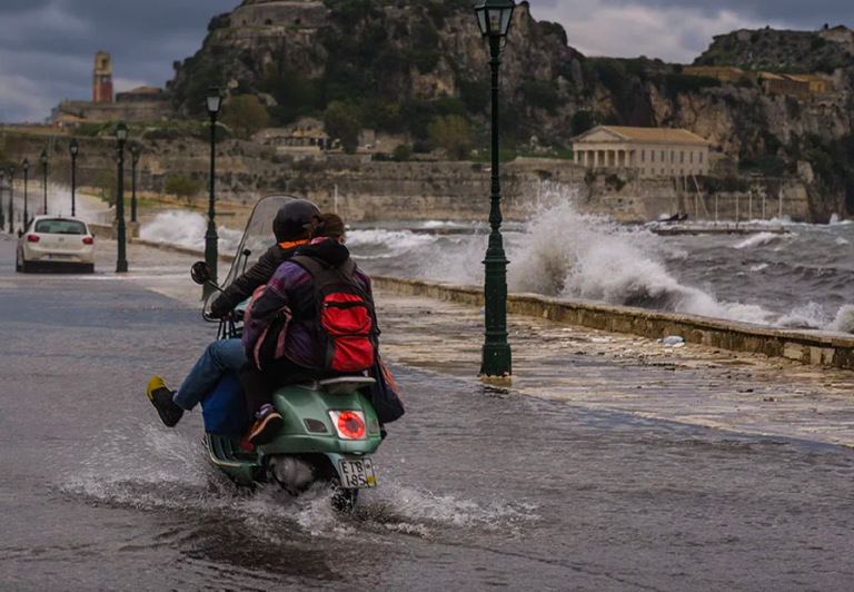
Severe bad weather is expected to hit Corfu for the second time in a few hours, with a team of three men from the 5th EMAK arriving on the island in a hurry to reinforce the local fire service.
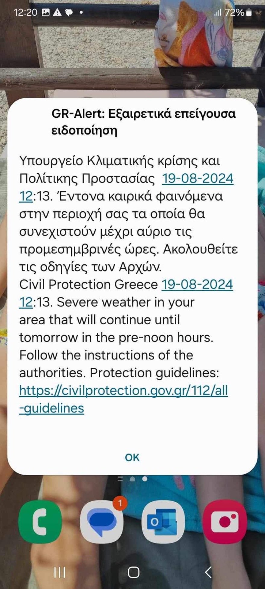
At noon on Monday, the General Secretariat of Civil Protection sent a 112 message to the island’s residents, urging them to be on alert for the extreme weather phenomena expected to hit the island by Tuesday morning.
Heavy rains occurred earlier on the island of Corfu causing many problems for residents as well as flooded manholes in the streets, while the city centre was left without power from 8am. According to the crews of DEDDIE, the outage was caused by lightning.
In northern Corfu, a fire broke out in a tree in Avliotes. According to information, the fire was caused by lightning. Immediately at the point, the Fire Department forces from the Thinalion fire brigade rushed to the spot.
Traffic gridlock prevailed on the island’s road entrances since morning. Due to the power cuts, several traffic lights were put out of operation.
There were also problems in flights with delays and cancellations due to the large amount of lightning at dawn. Two flights were unable to land. The first from Frankfurt, which made a temporary diversion at Preveza airport and returned to Corfu at 10:22 a.m., while the second from the Czech Republic, which returned to Athens and is expected to land in Corfu in about an hour.
According to the forecast maps from windy.com, the “eye” of the bad weather wave will hit central and northern Corfu from late afternoon to night, with heavy rainfall.
M meteo map
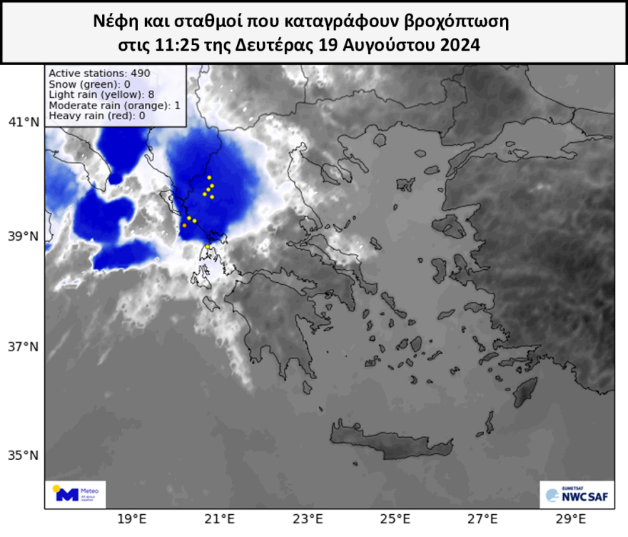
The image below shows the clouds as recorded by the Meteosat-10 satellite (the highest/coldest peaks are shown in blue) as well as the meteo.gr/National Observatory of Athens network stations recording rain at 11:25 GMT. Stations recording weak precipitation are marked with yellow dots, those recording moderate precipitation with orange dots and those recording heavy precipitation with red dots. It is worth noting that by 11:40 the station of Paxos has recorded 45 mm of rain.
It is recalled that earlier on Monday afternoon, EMY issued an emergency weather bulletin, warning of heavy rain, thunderstorms and heavy rainfall in the west, central and north of the country.
A few minutes after 12 noon, 112 was sent to residents in areas of western Greece, warning of severe weather.
A warning message, via 112, about dangerous weather phenomena was received on mobile phones at about 12:15 p.m. by residents of Patras and the wider region of western Greece.
⚠️ Enable 1⃣1⃣2⃣
?#Western_Greece
? Warning message for severe weather in your area which will continue until midday tomorrow
ℹ️ https://t.co/mbLpAekqgN@pyrosvestiki@hellenicpolice
– 112 Greece (@112Greece) August 19, 2024</blockquote
According to the warning message, severe weather is forecast to continue until the early hours of tomorrow, while citizens are urged to follow the instructions of the authorities.
Heavy rain and thunderstorms are forecast:
Today Monday (19-08-24)
In the northern Ionian Sea, Epirus, western Macedonia and possibly in central Macedonia and western Thessaly.
On Tuesday (20-08-24)
In Macedonia, Thrace and possibly in Thessaly.
The sudden change in the weather has already been noticed by those who are in the north-northwestern part of the country and in areas such as Kilkis, Thessaloniki, Ioannina, where intense weather phenomena with rain, storms and hail occurred. Roads turned into rivers, crops were damaged and the fire brigade received dozens of calls for tree felling and water pumping.
Dozens of firefighters were dispatched to the area, and water was pumped out and water supplies were also lost.
The 112 message for Ithaca
According to meteorologists and the Civil Protection the intense lightning activity will last for two days, mainly in areas of northwestern Greece.
Heavy rainfall and snowfall caused various problems in cities. Streets turned into rivers, crops were damaged and the fire department received dozens of calls to cut down trees and pump water while workers at food outlets tried to keep the water out of businesses. In fact, videos were posted on social media from Veroia, Kilkis, Thessaloniki, Giannitsa, Tyrnavos, Imathia, Kozani, Pella, Ioannina and Corinthia.
The WEEKLY WEATHER FORECAST
On Monday we will have showers and thunderstorms mainly after noon in the Ionian Sea, Epirus, Macedonia, Thessaly, Western Sterea and possibly the mountains of the Peloponnese The phenomena in the Northwest will probably be intense.
On Tuesday, the unsettled weather will continue with northerly winds and local thunderstorms in the Ionian Sea and the mainland mainly in the afternoon and the phenomena locally in the Ionian Sea Central and North. Greece are likely to be intense. The temperature will show a drop .
On Wednesday, sporadic phenomena in almost all continental areas – but not intense – with a slight further drop in temperature in the east and south .
No significant rainfall is forecast for the weekend Thursday and Friday, while there will be a gradual rise in temperature and strengthening winds to 6-7 Beaufort on Friday.
The weather next weekend will not change significantly.
THE WEEKLY WEATHER OUTLOOK
✅ Monday will feature #rain and #thunderstorms mainly after noon in the Ionian Sea, Epirus, Macedonia, Thessaly, Western Sterea and possibly the mountains of the Peloponnese.
✅ On… pic.twitter.com/oSDxNyTXec– Theodoros Kolydas (@KolydasT) August 18, 2024
The weather of the new week – What Dimitris Ziakopoulos predicts
Monday (19/8)
Weather. The phenomena in the North. Ionian, Epirus and central-western Macedonia are likely to be intense.
Winds: Variable 3 to 4 Beaufort.
Maximum temperatures: 35 to 37 degrees Celsius.
Tuesday (8/20)
Weather: showers and local thunderstorms in the Ionian Sea and the mainland mainly in the afternoon. The phenomena will be intense in places in the Ionian Sea, Epirus, Thessaly and Macedonia.
Winds: West to 5 Beaufort.
Temperature.
In the north and north-western parts of the region, with a slight drop in the north and north-western parts of the country.
WEDNESDAY (21/8)
21.21.24. Aegean and mountainous Crete.
The mainland, the south-eastern part of Greece and the north-eastern part of Crete.
Winds: N-NW 4 to 5 and possibly in the western and southern seas 6 Beaufort,
Temperature: slightly falling in the east and south.
Thursday – Friday (22-23/8)
Weather:No significant rainfall is forecast.
Weather.
Winds: N-NW 4 to 5 Beaufort and in the east 6 Beaufort. On Friday, possibly locally in the Aegean Sea up to 7 Beaufort.
Temperature.
Saturday-October (24-25/8)
No significant change in the weather is in sight.
Flooding and damage from the sudden storm in Ioannina – PPC column ended up on the balcony of an apartment
Streets turned into rivers, cars stalled in the middle of the road, roofs ripped off by the strong winds, trees falling on the pavement are some of the problems brought by the powerful storm that hit the city of Ioannina, causing flooding in homes located in low-lying areas of the city.
Shortly after 4 p.m. Sunday, the city was hit by torrential rain and hailstorms.
The biggest problems were on Archbishop Makarios, Voyannou and Garivaldi streets. While suburbs such as Perama and Neochoropoulos were also affected.
The abrupt change in the weather has already been noticed by those in the north-northwestern part of the country and in areas such as Kilkis, Thessaloniki, Ioannina, where intense weather phenomena with rain, storms and hail occurred. Roads turned into rivers, crops were damaged and the fire brigade received dozens of calls for tree felling and water pumping.
The strong winds caused tree branches to break off and fall into the road while the fire brigade received several calls for pumping water from basements and cutting down trees. Within a few minutes streets turned into rivers, while due to the volume of water that fell, the traffic of vehicles is being handled with great care, as reported by epiruspost.
Ask me anything
Explore related questions