Temperatures will gradually rise through the end of the week. According to the latest forecast data from meteo.gr / National Observatory of Athens, during the next few days the atmospheric circulation will favor the transfer of warm air masses towards our country. In fact, from tomorrow (25/09) onwards the air masses affecting the weather in Greece are expected to be warmer than normal for the season.
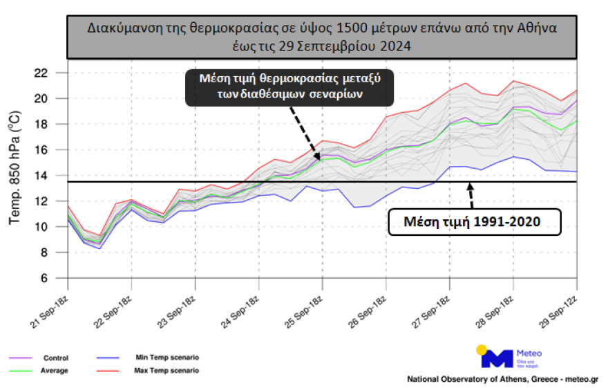
The graph in the following picture shows the range of variation of the temperature forecast until 29/09 at an altitude of about 1500 meters above Athens. The red line shows the “warmest” scenario while the blue line shows the “coldest” scenario. The green line shows the variation of the mean temperature based on all available scenarios of the model. Finally, the black horizontal line marks the approximate mean value for the period according to data for the period 1991-2020. As can be seen, all scenarios confirm the gradual increase in temperature and the higher than normal values for the season. The altitude of 1500 m is used to study temperature changes in the lower part of the atmosphere. It is noted that the final temperature configuration near the ground depends on a number of factors such as e.g. the presence/absence of clouds and phenomena and wind.

Marousakis’ forecast for the development of the phenomena
“In the temperature diagram or as I like to call it “truth diagram” since it includes the multiple solutions of the meteorological models that show us the prevailing trend of the weather, we can observe the upward trajectory of the temperature where towards the end of the week in the prefecture of Attica we will find mercury near 34 degrees Celsius as the maximum temperature.
It is also worth noting that observing the same diagram towards its end we see the temperature curves descending steeply which shows us a sharp change in the weather that will be accompanied by a vertical drop in mercury and which is timed for the beginning of next week and which we will refer to when our forecast data can lead to more stable conclusions.
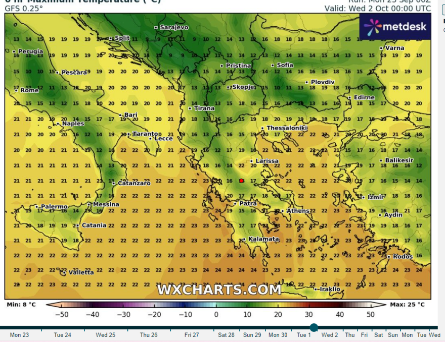
The temperatures in the country in the first few days of October

Until then, enjoy the summer with a caution until Wednesday to the west where instability seems to prevail.”
With the summer weather returning to our country once again, it is expected to be a rolling…
Posted by Klearhos Marousakis on Sunday, September 22, 2024</blockquote
A strong blocking anticyclone is coming in early October – What problems it creates for the weather
A strong blocking anticyclone is expected to develop in the coming period, resulting in the absence of rainfall, says Thodoros Kolydas in a new post.
? THE PREDICTION OF ATHLETICS IN BRIEF, WELL AND IN CONDUCT
✅Weather predictability is changing…Posted by Theodoros Kolydas on Monday, September 23, 2024</blockquote
The anticyclone blocker, it says, will block and prevent central European systems from moving into our region.
The post by Thodoros Kolydas
THE WEATHER FORECAST UP TO THE FIRST WEEK OF OCTOBER
✅The rise in temperature from the beginning of next week will be the main feature of the weather. From early October we return to normal temperature levels.
✅In terms of precipitation, nothing encouraging is discernible. The only exception is some phenomena at the end of the month. Since the beginning of October a strong blocking anticyclone has been developing. This strong anticyclone will block and prevent the central European systems from moving towards our region and this will result in the absence of rain.
? THE WEATHER OUTLOOK UNTIL THE FIRST WEEK OF OCTOBER
✅Weather temperatures will be the main feature of the weather from the beginning of next week. From the beginning of October we return to normal temperature levels.
✅In terms of precipitation… pic.twitter.com/LAndFdVnn9– Theodoros Kolydas (@KolydasT) September 21, 2024</blockquote
The weather today
A few local clouds are expected at times, while sporadic showers will occur in the afternoon and afternoon in the Ionian Sea and in mountainous areas of Western Macedonia, Epirus, Western Thessaly, Central and Western Sterea and Peloponnese.
The temperature in Western Macedonia will range from 12 to 25 degrees Celsius, in the rest of Macedonia and Thrace from 13 to 29, in Thessaly from 16 to 29, in Epirus and Western Central Greece from 14 to 28, in the rest of Central Greece from 14 to 29, in the Peloponnese from 12 to 29, in the Ionian islands from 17 to 26, in the North and East Aegean islands from 14 to 29, in the Cyclades and the Dodecanese from 16 to 28 and in Crete from 13 to 29 degrees Celsius.
Winds in the Aegean Sea will blow from variable directions from 2 to 4 Beaufort. In the Central Aegean the winds will initially blow from northern directions from 2 to 4 Beaufort but from the afternoon they will become westerly to north-westerly of the same intensity. In the southwestern Aegean, winds will blow from variable directions from 2 to 4 Beaufort. In the southeastern Aegean, winds will blow from northwestern directions from 2 to 4 Beaufort and locally up to 5 Beaufort. In the Ionian Sea the winds will initially blow from southerly directions 2 to 4 Beaufort but from noon onwards will gradually shift to southwesterly to westerly winds of the same intensity.
MAKEDONIA, THRACE
Weather.
Visibility will be locally limited in the morning hours in western Macedonia.
Winds: Variable 3 to 4 Beaufort, and in the sea occasionally from the south with the same intensity.
Temperature: From 14 to 28 degrees Celsius. In western Macedonia 3 to 4 degrees lower.
IONIAN, EPIRUS, WESTERN MAINLAND, WESTERN PELOPONESOS
Weather. Isolated thunderstorms are likely in the Ionian Sea mainly until the afternoon hours. In the western Peloponnese a few clouds, partly increasing in the midday-afternoon hours.
Winds: From southerly directions 3 to 4 Beaufort.
Temperature: From 18 to 28 degrees Celsius. In the interior of Epirus 3 to 4 degrees lower.
EASTERN and CENTRAL GREECE, EVIA, EAST PELOPONNESE
Weather.
Winds: Variable 3 to 4 gusts.
Temperature: From 17 to 29 locally in the mainland up to 30 degrees Celsius.
CYCLADES, CRETE
Weather: generally clear with a few clouds in Crete until the afternoon.
Winds: From the north 3 to 4 gusts.
Temperature: From 21 to 27 and in Crete up to 29 degrees Celsius.
From 21 to 21 degrees Celsius and from 21 to 29 degrees in Crete.
EAST AEGEAN ISLANDS – DODECANESE
Weather: light clouds and from the afternoon generally clear.
Winds: From the north 3 to 4 gusts.
Temperature: From 21 to 29 degrees Celsius. In the north 2 to 3 degrees lower.
THESSALY
Weather: a few clouds, locally increasing in the midday-afternoon hours.
Winds: Variable 3 to 4 Beaufort.
Temperature: From 14 to 28 degrees Celsius.
ATTICA
Weather: generally clear with sparse clouds in the morning hours.
Winds: Variable 3 to 4 Beaufort
Temperature: From 18 to 29 degrees Celsius.
THESSALONIKI
Weather.
General general conditions, mostly in general: Variable 3 to 4 Beaufort.
Temperature: From 15 to 28 degrees Celsius.
WEDNESDAY 25-09-2024
In the Ionian Sea and Epirus, cloudy at times with local rain and possibly isolated thunderstorms.
In the rest of the country a few clouds that will increase in the afternoon hours on the mainland and in the west and north there will be local rain or rain showers.
Visibility will be locally limited in the morning and evening hours.
Winds will blow south at 3 to 4 Beaufort and only in the southeastern Aegean northwest at 4 to 5 Beaufort.
The temperature will rise slightly and will reach 26 to 28 degrees Celsius in most areas and 29 to 30 degrees Celsius in some places on the eastern mainland and the Dodecanese.
THURSDAY 26-09-2024
In the Ionian Sea and Epirus a few clouds, partly increasing in the morning hours, when local rain is expected. In the rest of the country initially generally clear weather, but in the midday – afternoon hours clouds will develop in the mainland and Crete and in the mountains there will be local rain.
Visibility will be locally limited in the morning and evening hours.
Winds will be variable 3 to 4 Beaufort and in the south northwest 4 to 6 Beaufort.
The temperature will not change significantly.
FRIDAY 27-09-2024
Nearly clear weather throughout the country.
Visibility will be locally limited in the morning hours, mainly in the west.
Winds will be variable 3 to 4 Beaufort, while in the south it will blow northwest 4 to 5 and locally in the southeast 6 Beaufort.
The temperature will rise slightly.
SATURDAY 28-09-2024
Clear weather throughout the country.
Visibility will be locally limited in the morning hours, mainly in the west.
Winds will be variable 3 to 4 Beaufort, while in the eastern and southern Aegean Sea the winds will blow northwest 3 to 5 Beaufort.
The temperature in most areas will be 2 to 4 degrees Celsius above normal for the season.
Ask me anything
Explore related questions


