The high-pressure system that has kept Greece dry is beginning to weaken, and by Sunday, a new weather pattern will bring rain, especially across western, central, and southern regions. This shift, expected to last until mid-next week, will bring a brief drop in temperature.
According to the forecast from EMY Director Theodoros Kolydas, a retrograding upper-level low moving in from the northeast on Sunday will bring colder air, but it won’t be enough to cause widespread rainfall. Instead, on Monday and Tuesday, a series of atmospheric troughs moving westward from the central Mediterranean will bring significant rain.
Kolydas, in a video update, shares the weather outlook until Tuesday. Due to the temperature drop, some snowfall might appear on higher mountain peaks by Monday, though it’s not expected to be heavy.
Meteorologist Klearchos Marousakis commented on the recent prolonged dry spell, explaining that over the last month, a strong high-pressure system blocked incoming storms. This lack of rain reminds many of the severe droughts Greece experienced in the early 1990s. Apart from some cooler, northerly winds signaling the end of summer, the weather felt unseasonably dry. Marousakis highlights that this year’s drought stands out due to last autumn and winter’s low precipitation, especially given the lack of snow in the mountains, a critical water reserve for groundwater.
He explains that the current high-pressure system is finally weakening due to colder air pushing in from the northeast. This will allow storms to start moving into Greece from the west, with the first rains expected on Sunday, spreading more widely by early next week. The western regions of Greece will experience rain initially, which will then spread to other areas.
Marousakis hopes that this rainy period will persist without bringing destructive floods, noting that November is often known for intense and potentially dangerous rainfall, especially with the sea still warm and capable of fueling storms.
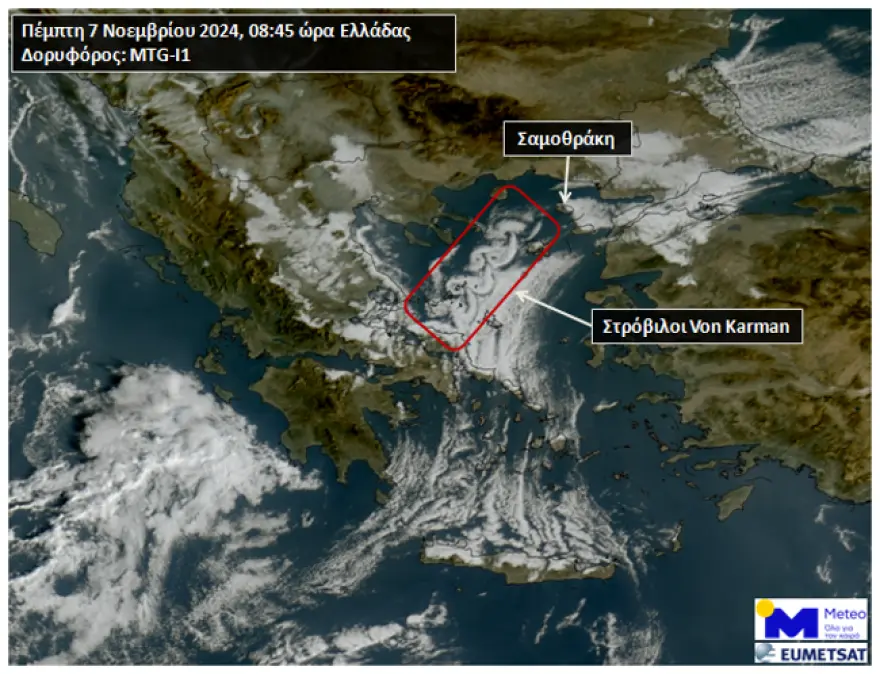
Von Karman Vortices in the Northern Aegean
On Thursday morning, November 7, the third-generation European geostationary meteorological satellite MTG-I1 captured impressive images of Von Karman vortices over the northern Aegean. These swirls are named after engineer Von Karman and are created when atmospheric airflow encounters obstacles. In this case, the swirls formed between Halkidiki, Lemnos, and the Sporades due to the high mountains of Samothrace, particularly Mount Saos (1,611 meters), interacting with strong northeast winds.
Today’s Weather Forecast
Expect patchy clouds, denser at times over the southern Ionian, Peloponnese, eastern Central Greece, Aegean, and Crete, with light, scattered showers likely in the southern Ionian, western Peloponnese, eastern Central Greece, Evia, and Crete. Visibility may be limited in mainland areas, especially in the morning and late evening.

Temperatures:
- Western Macedonia: -3°C to 15°C
- Rest of Macedonia and Thrace: 0°C to 20°C
- Thessaly: 3°C to 19°C
- Epirus and Western Central Greece: 5°C to 24°C
- Peloponnese: 5°C to 23°C
- Ionian Islands: 13°C to 21°C
- Northern and Eastern Aegean: 9°C to 20°C
- Cyclades: 13°C to 19°C
- Dodecanese: 9°C to 22°C
- Crete: 11°C to 18°C
Winds:
- Aegean: Northern, 4-6 Beaufort
- Ionian: Eastern, 2-4 Beaufort (Patraikos Gulf 3-5)
For the rest of the regional and daily forecast details, stay tuned for the upcoming shifts in weather through the weekend and next week, with cooler temperatures and more widespread rain on the way.
Ask me anything
Explore related questions


