Weather Update: A new cycle of bad weather will begin with rain expected in Attica until noon. A significant weather shift is expected from today until Saturday, featuring rain and thunderstorms across the entire country, with snow in mountainous areas in central and northern Greece. Heavy rain will affect several areas in eastern Greece, including Attica.
☔️ΤΙ ΠΡΟΚΑΛΕΙ ΤΟΝ ΔΕΥΤΕΡΟ ΚΥΚΛΟ ΒΡΟΧΟΠΤΩΣΕΩΝ
— Theodoros Kolydas (@KolydasT) November 13, 2024
Το ΝΔ ρεύμα έφερε πολλές βροχές κυρίως στη Δυτική Ελλάδα . Με βάση τα νέα προγνωστικά από την ΕΜΥ σας ενημερώνουμε ότι ξεκινά ένας νέος κύκλος βροχοπτώσεων κυρίως την Παρασκευή και το Σάββατο, όπου έρχεται ένα ανώτερο χαμηλό από την… pic.twitter.com/vLOF4oYVu9
According to Thodoris Kolydas, director of the Hellenic National Meteorological Service (EMY), “The southwest stream brought heavy rainfall primarily in Western Greece. Based on the latest forecasts from EMY, we inform you that a new rain cycle begins mainly on Friday and Saturday, with an upper low arriving from Italy, accompanied by cold and unstable air masses. The much-anticipated rain will also affect the eastern regions, while temperatures will remain below normal levels.”
Σας ενημερώνουμε ότι για την Αττική την Πέμπτη προβλέπονται βροχές και σποραδικές καταιγίδες πιθανώς κατά τόπους έντονες τις πρωινές και προμεσημβρινές ώρες κυρίως στα δυτικά και νότια. Βελτίωση προβλέπεται από τις μεσημβρινές ώρες και μετά .https://t.co/Gy8J0KaBJe pic.twitter.com/5CMqN92Abx
— Theodoros Kolydas (@KolydasT) November 13, 2024
For Attica, Kolydas mentions based on EMY’s forecast: “Rain and isolated thunderstorms are expected on Thursday morning, possibly intense in certain areas, particularly in the western and southern parts. Weather improvement is forecasted from midday onwards.”
Sakis Arnaoutoglou notes: “There is a chance of locally intense phenomena in Attica during the morning and pre-noon hours of Thursday (14/11/2024). Very strong and cold north winds are expected mainly on Saturday (16/11/2024), with a possibility of snowfall in Florina and Ptolemaida on the night of Friday (15/11/2024) into early Saturday morning (16/11/2024).”
Klearhos Marousakis in a social media post mentions an extensive low-pressure system approaching, which will cover most of Europe, bringing significant rain and snow.
“The balance of nature. Despite recent discussions about climate change and its impacts, nature has mechanisms to restore equilibrium. The occurrence of extreme weather phenomena is an attempt by nature to rebalance itself. Thus, while in recent weeks much of Europe was under high atmospheric pressure, preventing the arrival of storms, the time for balance comes next week when an extensive low-pressure system will cover a significant part of the continent, bringing heavy rain and snow. Our country will also experience this change. Finally, autumn and normal weather! The weather has its turns… Have a lovely evening, everyone,” wrote the meteorologist.
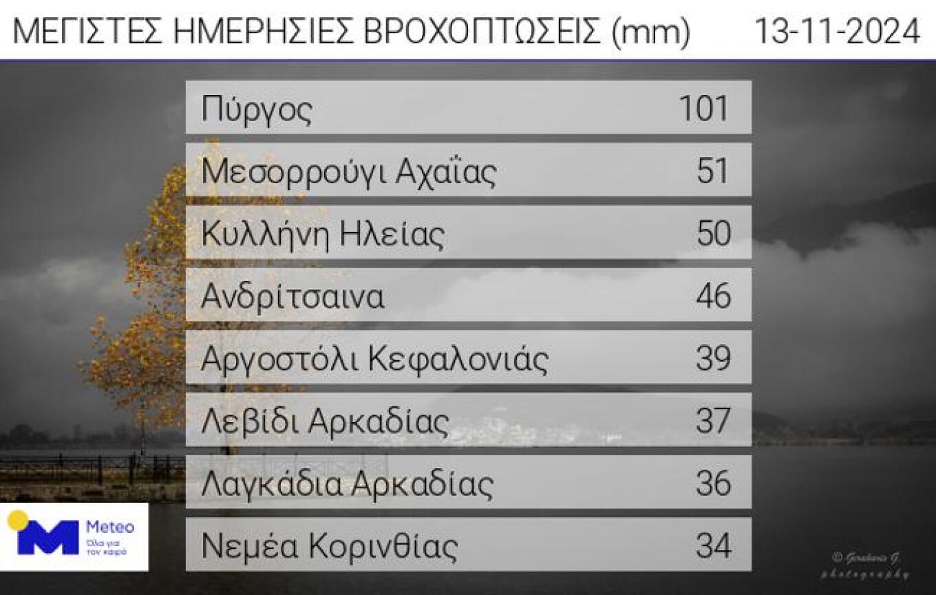
Rainfall Exceeds 100 mm in Pyrgos
Thunderstorms affected Pyrgos, Ilia, from midnight until 7 AM on Wednesday, November 13, with a total rainfall of 101 mm, according to the automatic meteorological station of meteo.gr/EAA in the city. Significant rainfall levels were recorded in several areas of the Peloponnese and the Ionian Islands, according to the network of automatic weather stations of the National Observatory of Athens/meteo.gr. The top eight rainfall levels until 10 AM on Wednesday, November 13, are presented in the table below.

Thursday’s Weather Forecast
Rain and thunderstorms are expected in most parts of the country. Exceptions include Crete, where only the western parts may be affected, and the Dodecanese, which will experience weather changes in the evening. Thunderstorms will be concentrated mainly in the western and southern parts of the country, with intense phenomena expected in the Ionian Islands, Epirus, and parts of Central Greece and Thessaly. There is a likelihood of hail, primarily in the western regions. The atmospheric circulation will favor the transport of dust in the Aegean and southern Greece.
Temperature and Wind Forecast
- Western Macedonia: 2°C to 12°C
- Rest of Northern Greece: 4°C to 13-15°C
- Thessaly: 8°C to 17-18°C
- Epirus: 8°C to 19-20°C
- Other Mainland Areas: 11°C to 21-23°C
- Ionian Islands: 15°C to 19-20°C
- Northern and Northeastern Aegean Islands: 8°C to 17-19°C
- Rest of the Aegean and Crete: 12°C to 22-24°C, with maximums locally reaching 26-27°C in Crete.
In the Northern Aegean, winds will blow from the northeast at 4-5 Beaufort. In the rest of the Aegean, southeast winds at 3-5 Beaufort will shift to westerly winds in the afternoon with similar intensities. Westerly winds will reach up to 4 Beaufort.
Ask me anything
Explore related questions


