
The weather is expected to worsen again, and snowfall cannot be ruled out in some mainland areas.
Specifically, according to meteorologist Klearchos Marousakis, heavy snowfall is expected across the mainland, even at very low altitudes. From Wednesday afternoon onwards, snow levels will gradually rise, leading to a temporary stabilization of conditions.
As he mentions, a new strong cold wave is likely around February 20.
His post
“The weather is expected to deteriorate from tomorrow afternoon in many parts of our country, resulting in heavy snowfall across the mainland, even at very low altitudes.
The cause of this development is a disturbance in the mid-atmosphere, marked by the red circle, which will transport more moisture to various atmospheric layers. Combined with the already existing very cold air masses, this will result in very heavy snowfall, even at very low altitudes (200 to 300 meters and above) across the mainland (maps 2,3).
From Wednesday afternoon onwards, snow levels will gradually rise, leading to a temporary stabilization of conditions.
The week is expected to close with milder temperatures, but another wave of bad weather is approaching from the northwest, bringing significant rainfall. However, snowfall will be limited to the mountains (map 4).
POSSIBLE NEW STRONG COLD WAVE AROUND THE 20TH OF THE MONTH
Our global forecasting system “HERCULES” is showing, in its longer-term scenarios, a new strong cold front that could bring snow to very low altitudes (map 6).
We are monitoring the situation and will provide updates when forecast data shows greater stability.”
EMY’s forecast for the coming days
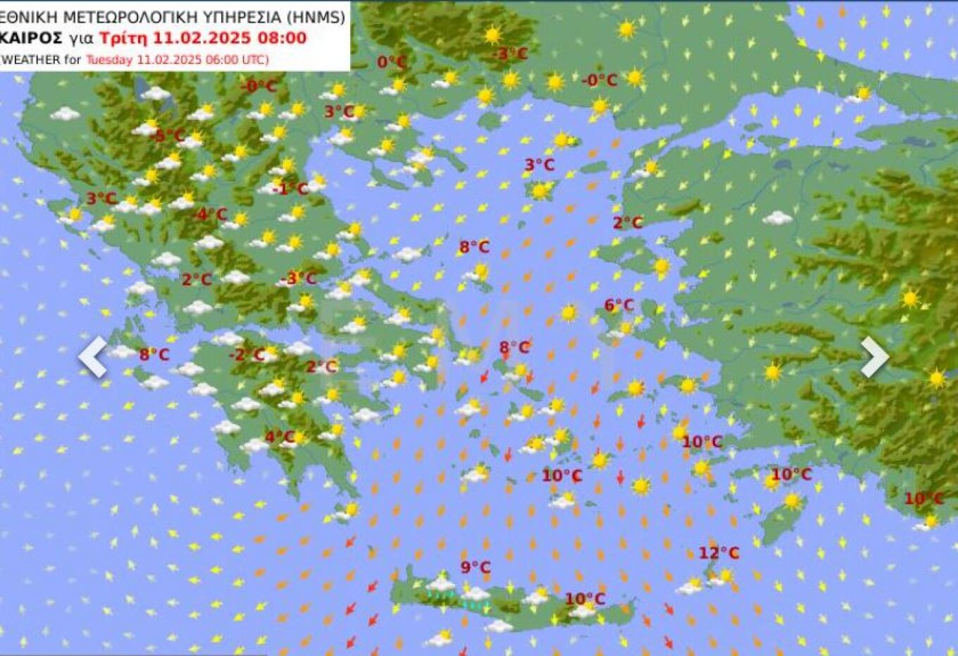
Tuesday, February 11
In eastern Macedonia, Thrace, and the Dodecanese, there will be scattered clouds. In the rest of the country, cloud cover will be temporarily increased, with light local rain, which will become more widespread in the Ionian, Epirus, Thessaly, and Central Greece from the afternoon. Light snowfall will occur in mountainous areas of the mainland, as well as in the highlands of Euboea and Crete.
Winds will blow from the east at 3 to 5 Beaufort in the west, and from the north-northeast at 4 to 6 Beaufort in the east, temporarily reaching 7 Beaufort in the southeastern Aegean.
Temperature will not change significantly and will remain 3 to 4 degrees Celsius below the seasonal average in central and southern mainland areas. In the Ionian Islands, western and southern mainland, Crete, the Dodecanese, and the southern Cyclades, temperatures will reach 13-14°C, while in the rest of the country, they will not exceed 8-10°C. Frost will occur locally in mainland areas during the morning and evening hours, with strong frost in the north.
Wednesday, February 12
In eastern Macedonia, Thrace, the eastern Aegean islands, and the Dodecanese, scattered clouds are expected. In the rest of the country, cloud cover will be temporarily increased, with local rain that will intensify in the Ionian from the afternoon, possibly leading to isolated thunderstorms. Snowfall will occur in the mountainous mainland, as well as in the highlands of Euboea and Crete.
Winds will blow from the southeast at 4 to 6 Beaufort in the west, increasing locally to 7 Beaufort in the Ionian from the afternoon. In the east, winds will blow from the north-northeast at 4 to 6 Beaufort, locally reaching 7 Beaufort in the southeastern Aegean, gradually weakening from the afternoon.
Temperature will not change significantly and will remain below normal for the season, particularly in the eastern and northern parts of the country. In the Ionian Islands, western Greece, Crete, the Dodecanese, and the Cyclades, temperatures will reach 12-13°C, while in the rest of the country, they will not exceed 8-11°C. Frost will occur in mainland areas during the morning and evening hours.
Thursday, February 13
Cloudy skies with local rain in the Ionian and mainland areas, spreading to Euboea and the Sporades by midday. Scattered thunderstorms will develop mainly over the Ionian Islands, western Central Greece, and the western Peloponnese. Snowfall will occur in the mountainous mainland and the highlands of Euboea.
Winds will blow from the southeast at 4 to 6 Beaufort in the west, reaching 7 Beaufort in the Ionian. In the east, winds will be northerly at 3 to 5 Beaufort but will shift to southerly-southeasterly up to 4 Beaufort in the afternoon.
Temperature will rise slightly in the west and south. In the Ionian Islands, western and southern mainland, Crete, the Dodecanese, and the Cyclades, temperatures will reach 13-15°C, while in the rest of the country, they will not exceed 8-11°C. Frost will occur locally in central and northern mainland areas in the morning and evening.
Friday, February 14
Increased cloud cover with local rain mainly in the Ionian, western and southern mainland, the Cyclades, and the eastern Aegean islands. Scattered thunderstorms will occur in the Ionian, western mainland, and possibly in the Cyclades and eastern Aegean from midday. Light snowfall will occur in mountainous mainland areas.
Visibility will be locally limited in the morning hours.
Winds will blow from the south at 3 to 5 Beaufort, locally reaching 6 Beaufort in the seas.
Temperature will rise and return to normal seasonal levels.
Saturday, February 15
Cloudy skies across the country with local rain. Scattered thunderstorms will mainly develop in the Ionian and eastern Aegean islands. Snowfall will occur in mountainous areas, particularly in central and northern mainland regions.
Winds will blow from the south at 3 to 5 Beaufort, locally reaching 6 Beaufort in the seas. However, in the north-northeast, they will shift to northerly directions from the afternoon and strengthen to 6-7 Beaufort, reaching 8 Beaufort in the northeastern Aegean overnight.
Temperature will remain relatively stable. Frost will occur locally in northern mainland areas in the morning and, more notably, in the evening hours.
Ask me anything
Explore related questions


