
A gradual rise in temperature will begin on Thursday (13/2), according to the latest forecast data from meteo.gr / National Observatory of Athens.
After nine days of lower-than-average temperatures, conditions will return to normal on Thursday. From Friday through Monday (17/2), temperatures are expected to rise further, reaching levels above the seasonal average. By next Tuesday, a cooling trend appears likely, but there is considerable uncertainty regarding the extent of this drop, as shown by the range of forecast scenarios.
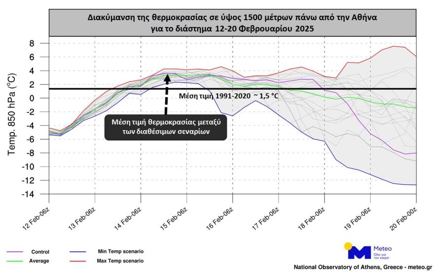
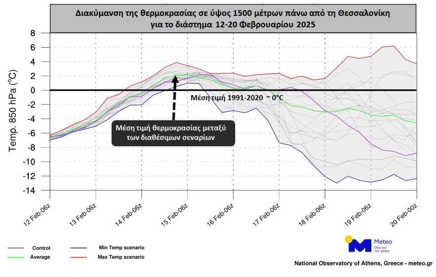
The following images illustrate the expected temperature fluctuations up to Thursday (20/2) at approximately 1,500 meters altitude above Athens and Thessaloniki. Athens is used as a reference for eastern and southern Greece, while Thessaloniki represents central and northern Greece.
The red line indicates the “warmest” scenario, while the blue line represents the “coldest” scenario. The green line shows the average temperature fluctuation based on all available model scenarios. Finally, a black horizontal line marks the approximate seasonal average, based on data from 1991-2020. As shown, temperatures are expected to be 3-4 degrees higher than usual for this time of year.
See the maps:
Detailed Forecast for Thursday, According to EMY
Cloudy skies with localized showers in the Ionian, central and southern mainland, and by the afternoon, in western Crete and Euboea. Isolated thunderstorms will mainly occur in the Ionian. Snowfall is expected in mountainous areas of the mainland and in the highlands of Euboea.
Winds will blow from the southeast at 4 to 6 Beaufort in the west, locally reaching 7 Beaufort in the Ionian. In the east, winds will be from easterly directions at 3 to 4 Beaufort, except in the Dodecanese, where they will be northwesterly at 4 to 6 Beaufort. Temperatures will rise slightly, mainly in terms of minimum values. In the north, temperatures will reach 9-11°C, in the west and southern Aegean 13-15°C, and in the rest of the country 11-13°C. Frost will occur in some central and northern mainland areas in the early morning hours.
MACEDONIA, THRACE
Weather: Partly to mostly cloudy skies. In western Macedonia, there is a chance of light rain and snowfall in the mountains.
Winds: Variable at 2 to 4 Beaufort.
Temperature: From -3°C to 11°C, and in western Macedonia up to 6°C.
IONIAN ISLANDS, EPIRUS, WESTERN MAINLAND, WESTERN PELOPONNESE
Weather: Cloudy with localized showers and isolated thunderstorms in the Ionian, potentially strong in the southern Ionian. Snowfall is expected in mountainous mainland areas.
Winds: Southeasterly at 4 to 5 Beaufort, increasing to 6 and temporarily reaching 7 Beaufort in the Ionian.
Temperature: From 6°C to 14°C. In the interior of Epirus, from 0°C to 6°C.
EASTERN MAINLAND, EUBOEA, EASTERN PELOPONNESE
Weather: Mostly cloudy with localized showers and snowfall in the mountains.
Winds: From easterly directions at 3 to 4 Beaufort.
Temperature: From 2°C to 11-13°C.
CYCLADES, CRETE
Weather: Partly cloudy, gradually increasing with some localized showers, mainly in western Crete.
Winds: Variable at 3 to 4 Beaufort.
Temperature: From 8°C to 12-14°C, and locally up to 15°C in Crete.
EASTERN AEGEAN ISLANDS – DODECANESE
Weather: Partly cloudy, increasing in the afternoon.
Winds: Northeasterly at 3 to 4 Beaufort in the north and northwesterly at 4 to 6 Beaufort in the south, gradually weakening.
Temperature: From 5°C to 12°C, and up to 14°C in the south.
THESSALY
Weather: Mostly cloudy with light scattered showers and light snowfall in the mountains.
Winds: From easterly directions at 3 to 4 Beaufort.
Temperature: From 2°C to 11°C.
ATTICA
Weather: Mostly cloudy at times.
Winds: From easterly directions at 3 to 4 Beaufort.
Temperature: From 4°C to 12-13°C. In the northern suburbs, temperatures will be about 2 degrees lower.
THESSALONIKI
Weather: Mostly cloudy at times.
Winds: Variable at 3 Beaufort.
Temperature: From 3°C to 10°C.
Forecast for Friday (14/2)
In central and eastern Macedonia and Thrace, skies will be mostly cloudy with a chance of light scattered showers. In the rest of the country, increased cloud cover will bring rain and sporadic thunderstorms over the Ionian Islands, the western mainland, and from midday onward, over Euboea, the eastern Aegean islands, the Dodecanese, and locally over the Cyclades. Light snowfall is expected in some western and northern mountainous areas.
Winds will be southerly at 3 to 5 Beaufort, with temporary gusts reaching 6 Beaufort over the seas. Temperatures will rise to seasonal norms, reaching 12-14°C in northern and central mainland areas, 15-16°C in the rest of the country, and 17-18°C locally in the Cyclades, Crete, and the Dodecanese.
Ask me anything
Explore related questions


