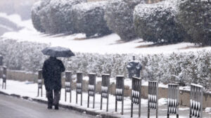
Comes very cold in the coming days in our country according to meteorologists’ forecasts as a “dip” in temperature and snow is expected in several areas of the country.
In fact, as EMY director Thodoros Kolydas says the cold invasion of our country is coming in two waves, presenting a graphic depiction.
🎯The graphic illustration of the cold invasion
✅Based on data from #EMY we have prepared a video showing the intense cold invasion, in the coming days in our country, which comes in two waves.
✅Today evening on Star’s Central News we will present… pic.twitter.com/QpoRqSyCeH– Theodoros Kolydas (@KolydasT) February 17, 2025</blockquote
🎯OTAN KOITAΣ ΑΠΟ ΨΗΛΑ …@EMY_HNMS @CivPro_GR @Starchannelnew1 @duthnac @Vkikilias @pyrosvestiki @meteociel pic.twitter.com/pzZXJZhFYo
– Theodoros Kolydas (@KolydasT) February 17, 2025
However, in an earlier post he said that “The main feature of this week in our country will be the prevalence of low temperatures 3 to 6 degrees below normal. On average, the maximum temperature will drop by 6 to 8 degrees compared to today’s temperatures.”
🥶🥶🥶 DRY and cold
✅The main feature of this week in our country will be the prevalence of low temperatures 3 to 6 degrees below normal levels .
✅ Mid-range maximum temperatures will drop by 6 to 8 degrees compared to today’s… pic.twitter.com/80uEAgpAmZ– Theodoros Kolydas (@KolydasT) February 17, 2025</blockquote
Kallianos: “A cold invasion is coming from Wednesday”
According to what Yannis Kallianos told Mega, there will be a further drop in temperature across the country from Wednesday (19/2) and onwards.
“We will see snowfall on Wednesday night in mountainous and semi-mountainous areas of the eastern mainland, namely in parts of Thessaly, central and eastern Sterea, above 500 meters in Attica, in Evia, in the eastern Peloponnese, and all these areas.
Snow will fall in Attica from Thursday onwards in Dionysos and possibly a little lower on Wednesday night. There, however, I don’t see it going any lower. On Thursday and Friday the temperature will drop 10-12 degrees Celsius,” he said, among other things.
“A polar invasion we don’t often see in our country”
Klearchos Marousakis also mentioned the deterioration of the weather in the coming days. Specifically, in his post he refers to a “polar invasion that we do not often see in our country.”
“Impressive data we just received from our forecast systems where we observe (map 1) the polar air mass coming with excellent temperature dynamics with the isotherm of -14° to -15° at 1500 meters to invade the northeast of our country. This bad weather will bring many surprises in my opinion both in terms of snowfall and extremely low temperatures. Our farmers should prepare for a long period of temperatures that will lead to the formation of frost, and those planning to travel on the road network should be informed both by the latest weather reports and by the route they plan to take about what they may encounter.
Remember… Anti-slip chains or any other acceptable anti-slip device, should be in our vehicle and most importantly, we should know how to fit them. In map 2, we can see the hydrological record from Wednesday through Thursday morning at about noon, where temperatures are favorable for snow very low.
Seeing a situation like this more than 10 days ago fills us with strength and optimism to continue this very difficult task, especially when you go against all the estimates some of which were calling for spring conditions! We are looking at the most remarkable cold invasion for this winter and beyond.
The big question mark is how the Aegean Sea in particular will behave in such a dynamic cold weather situation, which will decide a lot on the snowfall issue.
See…. Meteorological models find it “dark” in the interaction of the lower atmosphere with the sea surface.
Also, the hydro maps don’t behave the same when you have such a cold low atmosphere where it completely changes the interpretation of a hydro scale of a forecast model,” he said in his post.
The weather forecast for February 19
Wednesday, February 19
In the eastern and southern mainland and the Aegean increasing clouds with local showers. In the rest of the country a few clouds, partly cloudy and partly cloudy. Snow will fall in the mountains and mountainous areas of the northern part of the country.
Winds will blow from the north, in the west 4 to 5 and the Ionian Sea locally 6 Beaufort, in the east 4 to 6 and in the Aegean Sea 7 and possibly locally up to 8 Beaufort. The temperature will drop throughout the country, which will be felt mainly in the central and northern regions. It will reach 6 to 8 degrees Celsius in the north, 8 to 11 degrees in the centre, 13 to 15 degrees in the west and 15 to 16 degrees Celsius in the islands. Frost will occur in places in the central and northern mainland.
Thursday, February 20
In the eastern and southern mainland and the Aegean, increasing cloudiness with light local rain or sleet. In the rest of the country a few clouds, partly cloudy and partly cloudy. Snow will fall in the continental mountains, the mountains of Crete, as well as in semi-mountainous areas of central and northern Greece. Winds will blow from northerly directions in the west 4 to 5, in the east 5 to 6 and in the Aegean Sea locally 7 Beaufort. Temperatures will drop further across the country and will be at a seasonally low level of 2 to 4 degrees. Frost will occur in places on the mainland.
Friday, February 21
In the eastern and southern mainland and the Aegean, increasing cloudiness with light local rain or sleet. In the rest of the country a few clouds, partly cloudy and partly cloudy. Snow will fall in the mountains of the eastern part of the country and in semi-mountainous and lower altitude areas of the eastern continent. Winds will blow from northerly directions in the west 4 to 5, in the east 5 to 6 and in the Aegean Sea 7 and possibly locally up to 8 Beaufort. The temperature will not change significantly and will remain at seasonally low levels. Frost will occur in places on the mainland.
Saturday, February 22
In the eastern and southern mainland and the Aegean, increasing cloudiness with light local rain or sleet. In the rest of the country a few clouds, partly cloudy and partly cloudy. Snow will fall in the mountains of the eastern part of the country and in semi-mountainous and lower-altitude areas of the eastern continent. Winds will blow in the west from the east 4 to 5 Beaufort, in the east from the north 5 to 6 Beaufort and the Aegean Sea locally 7 and possibly up to 8 Beaufort, weakening from the afternoon. The temperature will not change significantly and will remain at seasonally low levels. Frost will occur in places on the mainland.
Ask me anything
Explore related questions


