The country is in the grip of cold. From today, Friday, until next Monday, the second wave of the Coral storm is expected to last, with very low temperatures, strong northerly winds, and snow even in semi-mountainous areas.
Snowfall is also expected in the northern suburbs of Attica. The most difficult day will be Sunday (23.02.2025).
Winter makes its presence felt starting today with very low temperatures, local snowfall in the mountains and semi-mountainous areas, while in Evia, where it has been snowing since yesterday, schools have been closed due to the weather conditions.
Winter weather scene – Snow in the mountains of Evia, how Coral storm will move in the coming hours
Low temperatures are expected in the eastern and northern parts of the country, local snowfall in the mountains and semi-mountainous areas of the eastern country, and in areas with lower altitudes, while schools in the municipalities of Dirfy-Messapia and Mantoudi-Limni-Agia Anna will remain closed due to the severe weather conditions.
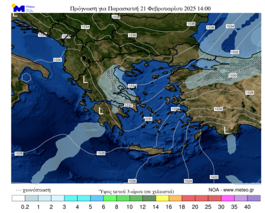
Specifically, according to the Hellenic Meteorological Service (EMY), today (21/2), in Macedonia, Thessaly, the Sporades, central and eastern Sterea, the eastern Peloponnese, Evia, the Aegean (except for the Dodecanese), and Crete, clouds with rain or sleet are expected. In the rest of the country, few clouds will temporarily increase. Weak snowfalls are expected in Macedonia (mainly central), Thessaly, central and eastern Sterea (including Attica), the eastern Peloponnese, Evia, and temporarily in the northern Aegean islands, in the mountains, semi-mountains, and locally in areas with lower altitudes, as well as in the mountains and semi-mountains of Crete.
Winds will blow from the east in the west at 4 to 5, locally up to 6 Beaufort. In the east, winds will blow from the north at 4 to 6, in the Aegean at 7, and in the south locally at 8 Beaufort. The temperature will continue to drop slightly and will remain at lower-than-usual levels for the season. Specifically, in the north, temperatures will reach 5 to 7 degrees, in the central parts 7 to 9 degrees, in the west 10 to 12, and locally 13 degrees, and in the southern island regions 9 to 11 and locally 12 degrees Celsius. Frost will occur locally in the central and northern mainland areas during the morning and evening hours.
Coral Storm – Meteo: Sunday, the Toughest Day for Attica
Temperatures will stay in single digits today, Friday, with the mercury expected to drop further as the Coral storm continues its advance across the country, with the Hellenic Meteorological Service’s (EMY) emergency bulletin still in effect.
The Weather in Attica
In Attica, the weather will alternate, with periods of thicker clouds and clear weather. When the clouds thicken, local snowfalls will occur, mainly weak, in the following areas of the region:
- Northwestern
- Northern
- Northeastern
- Eastern
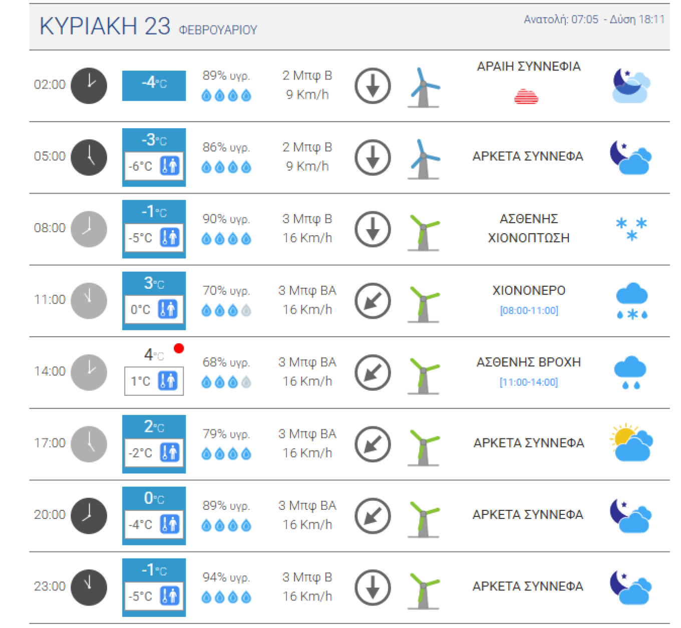
Coral Storm – Meteo: Sunday, the Toughest Day with the Mercury Dropping Below Zero
The Weather Outlook – What Dimitris Ziakopoulos Predicts
Dimitris Ziakopoulos forecasts the continuation of low temperatures almost throughout the country and strengthened northerly winds in the eastern and southern parts of Greece (main intensity 6 to 7 Beaufort).
Occasional weak to moderate snowfall will be seen in Eastern Thessaly, Fthiotida, Boeotia, and Evia, while weak local snowfalls will also occur in other eastern mainland areas of the country, central Macedonia, the Aegean islands of North-East Aegean, and the mountains and semi-mountains of the Cyclades and Crete.
In Attica, occasional weak snowfalls will occur mainly in the mountains, semi-mountains, and higher points of the northern suburbs.
Today’s Weather: The Detailed Forecast from the Hellenic Meteorological Service
Forecast for Today, Friday, 21-02-2025
Warnings
Low temperatures are expected in the eastern and northern parts of the country. Local snowfalls are expected in the mountains and semi-mountains of the eastern country, as well as in areas with lower altitudes.
General Features
In Macedonia, Thessaly, the Sporades, central and eastern Sterea, the eastern Peloponnese, Evia, the Aegean (excluding the Dodecanese), and Crete, cloudy weather with rain or sleet is expected. In the rest of the country, there will be few clouds, occasionally increasing.
Weak snowfalls are forecast for Macedonia (mainly central), Thessaly, central and eastern Sterea (including Attica), the eastern Peloponnese, Evia, and temporarily in the northern Aegean islands, in the mountains, semi-mountains, and locally in lower-altitude areas, as well as in the mountains and semi-mountains of Crete.
Winds will blow from the east in the west at 4 to 5, locally up to 6 Beaufort. In the east, winds will blow from the north at 4 to 6, in the Aegean at 7, and in the south locally at 8 Beaufort.
The temperature will decrease slightly further and remain lower than usual for this time of year. Specifically, in the north, temperatures will reach 5 to 7 degrees, in the central parts 7 to 9 degrees, in the west 10 to 12, and locally 13 degrees, and in the southern island areas 9 to 11 and locally 12 degrees Celsius.
Frost will occur locally in the central and northern mainland areas during the morning and evening hours.
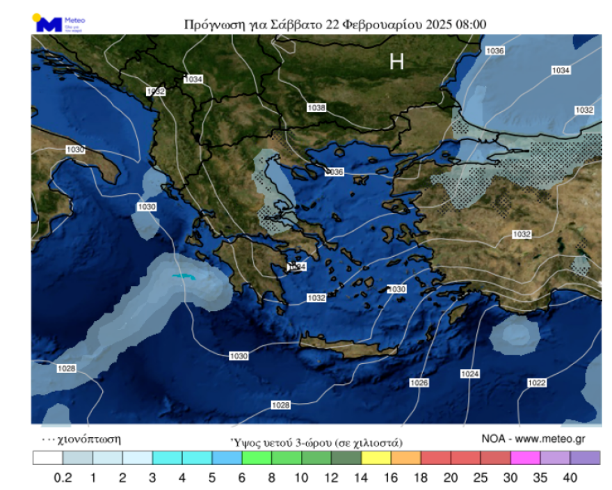
Tomorrow’s Weather – Which Areas Will Be Affected by Coral Storm, Snow, and Strengthened Winds
In the eastern mainland, central Macedonia, the Cyclades, and Crete, increased clouds with weak local rain or sleet.
Snowfalls, mostly weak, will occur:
a) in the mountains, semi-mountains, and locally in lower-altitude areas in Macedonia (mainly central), Thessaly, central and eastern Sterea (including Attica), the eastern Peloponnese, Evia, and the northern and central Aegean islands,
b) in the mountains, semi-mountains, and possibly locally in lower-altitude areas in Crete, and
c) locally in the mountains of the Cyclades.
In the rest of the country, few clouds will temporarily increase.
Winds will blow from the east in the west at 3 to 5, from the north-northeast in the east at 5 to 6, and in the central and southern Aegean at 7 to 8 Beaufort, gradually weakening.
The temperature will continue to drop slightly. It will range in the north from -5 (minus 5) to 4 to 6 degrees, in the central and eastern mainland and Evia from -3 (minus 3) to 6 to 8 degrees.
In the remaining areas, temperatures will reach 9 to 11 degrees Celsius.
Frost will occur locally in the mainland.
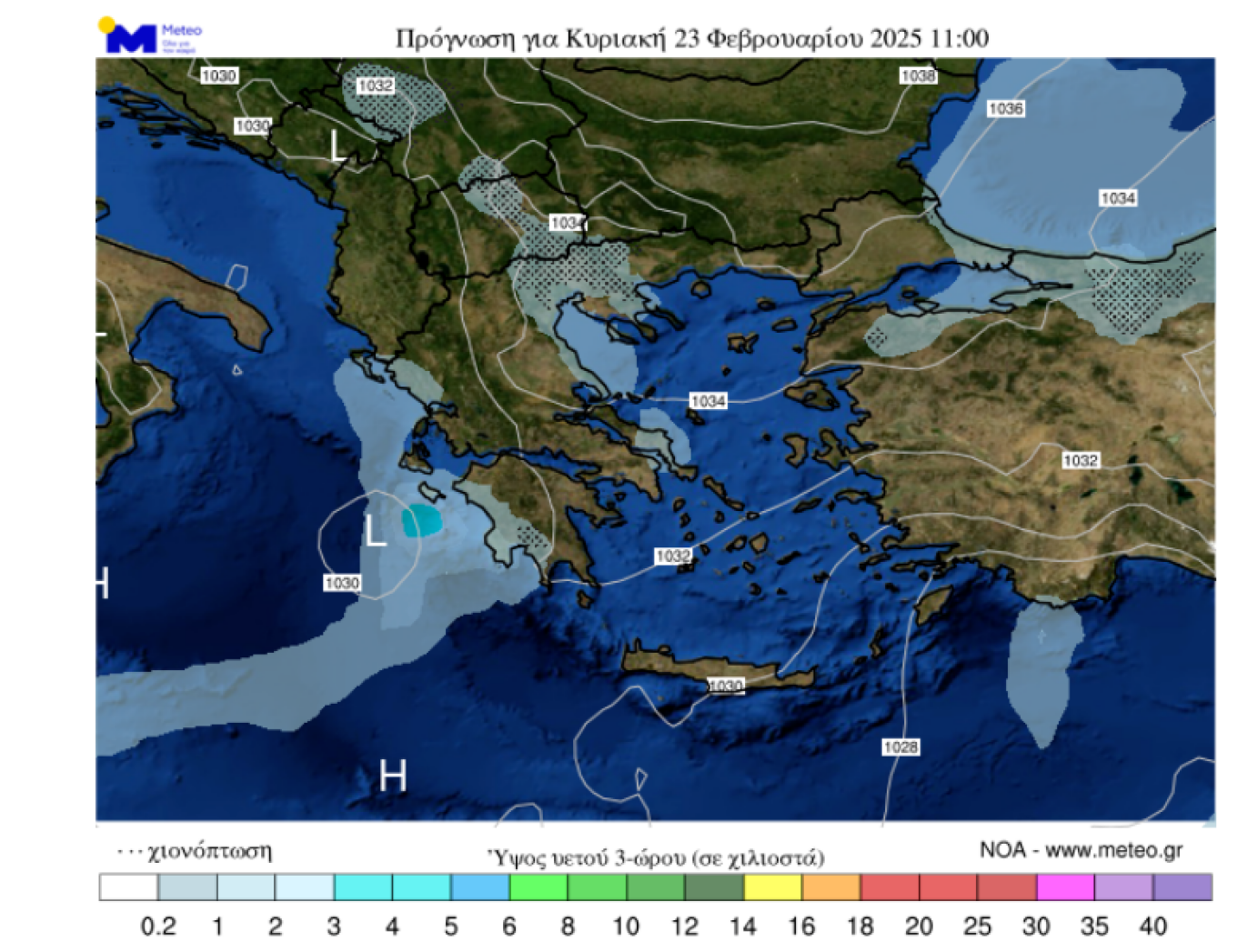
Weather on Sunday
In Thrace, the eastern Aegean islands, and the Dodecanese, few clouds are expected.
In the Ionian, increased clouds with rain and, from the afternoon, sporadic thunderstorms in the southern sections.
In the rest of the country, clouds will increase temporarily, with weak local rain or sleet. Snow will fall in the mountains, semi-mountains, and in areas with lower altitudes in the eastern and northern mainland and the islands of the northern Aegean.
Winds will blow from the southeast in the west at 3 to 5, from the north in the east at 4 to 6, and in the southern Aegean locally at 7 Beaufort.
The temperature will not change significantly and will remain very low.
Frost will occur locally in the mainland.
Ask me anything
Explore related questions