Cold Front Continues to Grip Greece: Saturday, February 22, Expected to Be Coldest Day
The ongoing winter conditions caused by the “Coral” weather system continue to affect Greece, with temperatures set to plummet on Saturday, February 22. The cold front will bring freezing temperatures and snow, especially in the northern and northeastern parts of the country. According to meteorologist Klearchos Marousakis, the coldest day will be Saturday, with temperatures dropping due to cold air masses from northeastern Europe, particularly the Black Sea region.
“Saturday will be the coldest day, as colder air from the northeast will bring freezing temperatures to the region. The coldest areas will be in Evros, eastern Macedonia, and the islands of the northeastern Aegean. Snow showers will not only occur in mountainous and semi-mountainous areas but will also reach lower altitudes in some regions. However, the snowfall will be minimal in the north, with precipitation levels quite low,” said Thodoros Kolydas, another expert from the Greek Meteorological Service.
Detailed Weather Forecast for Saturday
The Greek Meteorological Service (EMY) has issued its flash report, which forecasts the following temperatures for Saturday:
- Macedonia, Thrace, and Northern Aegean Islands: Temperatures will range from -5°C to 6°C, with snow expected in the mountains and possibly lower altitudes.
- Thessaly, Central and Eastern Sterea, Eastern Peloponnese, and Evia: Expect temperatures ranging from -3°C to 8°C, with light snow in higher areas.
- Crete: Snowfall is predicted in the mountains and semi-mountains, with the possibility of lower-altitude snow.
In Athens, light snowfall is expected in the mountains and semi-mountains, as well as in some lower-altitude areas. Winds will be northeasterly, reaching 4-5 Beaufort, strengthening up to 6 Beaufort in the east. Temperatures will range from 1°C to 7°C. Similarly, Thessaloniki will see light snowfall in the surrounding mountains and semi-mountains, with temperatures between -1°C and 7°C.
Weather Across the Country
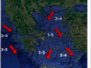
- Macedonia and Thrace: Expect light snowfall in the mountains and semi-mountains, as well as in lower altitudes. In Thrace, the weather will be mostly cloudy with a few light showers and snow in the mountains. Winds will be northerly, reaching up to 6 Beaufort, and temperatures will range from -1°C to 6°C, dropping even further in western Macedonia.
- Ionian Islands, Epirus, Western Sterea, Western Peloponnese: The weather will be mostly cloudy, with light snow in mountainous areas. Winds will be from the east at 3-5 Beaufort, and temperatures will range from 2°C to 13°C, lower in the interior of Epirus.
- Central and Eastern Greece, Crete: Light snowfall is expected in the mountains and semi-mountains, with gradual weakening in the evening. Winds will be northeasterly, reaching 4-6 Beaufort, and temperatures will range from -3°C to 8°C.
Weather on Sunday, February 23
The cold weather will continue into Sunday, with temperatures ranging from -4°C to 7°C in the northern and eastern parts of the country, and from -1°C to 11°C in central and eastern Greece. Snowfall will persist in mountainous areas of Macedonia, Thessaly, and Evia, as well as in the mountains of Crete.
Showers are expected in the western and southern parts of the country, especially in the Ionian Sea and the western Peloponnese. Winds will be from the north-northeast at 3-5 Beaufort, strengthening in some areas to 6 Beaufort. The temperature will remain low, with frost expected in many areas.
Outlook for Next Week
According to Marousakis, very low temperatures will persist until Monday, with the potential for frost forming during the early morning hours. Following this cold spell, a new weather system will arrive from Western Europe, bringing rain and snow to mountainous areas. Temperatures are expected to rise gradually by Monday, signaling the end of the cold snap.
Monday, February 24:
Clouds will increase across the country, with rain and sleet in the east and sporadic showers and thunderstorms in the west. Snow will continue to fall in the mountains and semi-mountains of the eastern mainland. Winds will be from the southeast at 3-5 Beaufort, with temperatures rising slightly in the west, while remaining low in the east. Frost will occur in the mainland.
Tuesday, February 25:
Heavy showers and sporadic thunderstorms are expected in the Ionian, western, central, and southern mainland, as well as in the Cyclades, northern and eastern Aegean islands, and the Dodecanese. Snow will continue to fall in the mountains of the mainland. Winds will be from the south at 3-5 Beaufort, turning to northwest in the Ionian Sea in the afternoon. Temperatures will rise throughout the country, with frost expected in some areas of northern Greece.
Wednesday, February 26:
The weather will improve in the northern parts of the country, but sporadic showers and thunderstorms are expected in the Cyclades, East Aegean islands, and Dodecanese. In the rest of the country, light rain and snow are expected in the mountains. Winds will gradually weaken, and the temperature will remain steady across the country.
Ask me anything
Explore related questions


