
The intense cold wave (named Coral) will continue to affect our country, as well as the broader region of Southeastern Europe and the Eastern Mediterranean, until Monday. At the same time, locally strong northerly winds of 7 to 8 Beaufort will prevail in the Aegean, accompanied by scattered snowfall—generally light—across the eastern mainland, the Aegean islands, and Crete.
So far, snowfall has been recorded in Evia and Parnitha, while biting cold dominates the rest of the country. The director of EMY, in a social media post, explained why there wasn’t significant snowfall on Tsiknopempti and pointed to a new emergency bulletin expected to be issued at noon. Additionally, Theodoros Kolydas mentions snowfall in Thessaly, Fthiotida, Viotia, Evia, and Attica.
“Today, Thursday (maps 1,2), the cold air mass at 850hPa has moved into the east, but there is insufficient upper-atmosphere support for significant snowfall since temperatures at 500hPa are not low enough, as described in meteorological literature. On Saturday (maps 3,4), conditions change slightly as lower temperatures are expected.
In the midday update of the emergency bulletin, we will provide detailed information on the evolution of the weather, which, in general, is summarized as the continuation of low temperatures across almost the entire country and strong northerly winds in eastern and southern Greece. Periodic light to moderate snowfall is expected in Eastern Thessaly, Fthiotida, Viotia, and Evia. Light local snowfall will also be observed in other eastern mainland regions, central Macedonia, the islands of the northeastern Aegean, and the mountainous/semi-mountainous areas of the Cyclades and Crete. In Attica, occasional light snowfall is expected mainly in the mountains and higher elevations of the northern suburbs,” Kolydas noted in his post.
ΜΙΑ "ΣΤΑΓΟΝΑ" ΜΕΤΕΩΡΟΛΟΓΙΑΣ
— Theodoros Kolydas (@KolydasT) February 20, 2025
✅ Μεταξύ πολλών μετεωρολογικών παραμέτρων οι θερμοκρασίες στα 850hPa και τα 500hpa διαδραματίζουν μεγάλο ρόλο για τη δημιουργία χιονοπτώσεων στον Ελληνικό χώρο .
✅ Στο εγχειρίδιο του Μετεωρολόγου προγώστη της ΕΜΥ περιγράφονται αναλυτικά τα κριτήρια… pic.twitter.com/Tk6VOykVJz
The peak of the severe weather is expected today and tomorrow, with a further drop in temperature, according to meteorologist Christina Rigou.
As MEGA’s meteorologist mentioned, snow will fall at lower altitudes in Magnesia, Fthiotida, Attica, and Evia.
Where in Attica Will It Snow?
For Attica, the heaviest snowfall is expected in Parnitha and the surrounding areas, such as Ippokratios Politeia, Kapandriti, Varnavas, and Thrakomakedones, according to the meteorologist.
Additionally, snowflakes will be seen in the northern suburbs, from Penteli and Dionysos upwards, with a light snow cover expected.
Emergency Bulletin from EMY in Effect
TEMPERATURES
Today, Friday (21-02-25)
a) In Macedonia and Thrace, from -7°C to 5-7°C.
b) In Thessaly, the northern Aegean islands, central and eastern Sterea, eastern Peloponnese, and Evia, from -2°C to 7-9°C.
Saturday (22-02-25)
a) In Macedonia, Thrace, and the northern Aegean islands, from -5°C to 4-6°C.
b) In Thessaly, central and eastern Sterea, eastern Peloponnese, and Evia, from -3°C to 6-8°C.
SNOWFALL
Today, Friday (21-02-25)
a) In Macedonia (mainly central), Thessaly, central and eastern Sterea (including Attica), eastern Peloponnese, Evia, and temporarily in the northern Aegean islands, in mountainous and semi-mountainous areas, and locally at lower altitudes.
b) In the mountainous and semi-mountainous regions of Crete.
Saturday (22-02-25)
a) In Macedonia (mainly central), Thessaly, central and eastern Sterea (including Attica), eastern Peloponnese, Evia, and the northern and central Aegean islands, in mountainous, semi-mountainous areas, and locally at lower altitudes.
b) In Crete, in mountainous, semi-mountainous areas, and possibly locally at lower altitudes.
c) In the Cyclades, at times in mountainous areas.
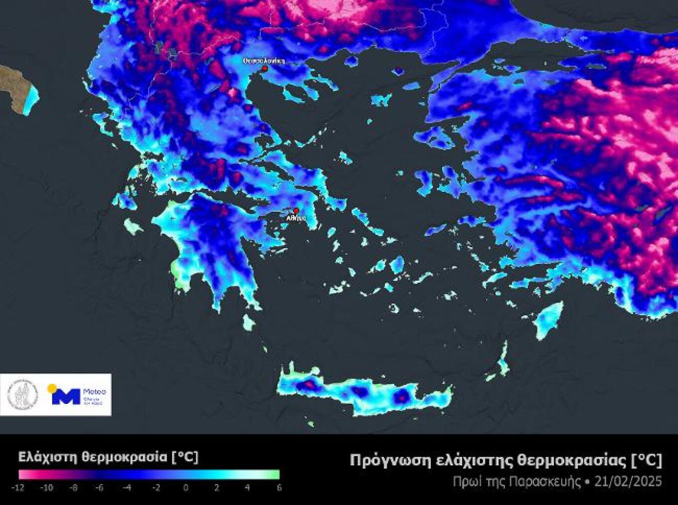
Meteo: Low Temperatures Expected in the Coming Days
According to the latest forecast data from meteo.gr / National Observatory of Athens, low temperatures are expected in the coming days. In the early morning hours, temperatures in semi-mountainous and mountainous regions of central and northern Greece will drop significantly below freezing, reaching below -10°C in some areas. The accompanying map illustrates the minimum temperatures expected on the morning of Friday, 21/02.
Additionally, light and temporary snowfall is expected in mountainous and semi-mountainous areas of Macedonia, Thessaly, Eastern Macedonia, Eastern Peloponnese, and Crete. Finally, northerly winds in the Aegean will remain strong, reaching 6 to 7 Beaufort in some areas.
Weather Today
Increased cloud cover is expected in Central Macedonia, Thessaly, Eastern Sterea, Eastern Peloponnese, and Crete, while other parts of the country will see clouds with occasional sunshine. Temporary snowfall is expected mainly in Central Macedonia, Thessaly, Eastern Sterea, the Peloponnese, and mountainous Crete. In low-altitude areas of the mainland (excluding Eastern Macedonia and Thrace), there is a chance of brief rain or sleet during the warmer hours of the day.
Temperatures in Western Macedonia will range from -8°C to 3°C, in the rest of Macedonia and Thrace from -5°C to 5°C, in Thessaly from -3°C to 7°C, in Epirus from -2°C to 12°C, in Western Sterea from 0°C to 11°C, in the rest of Sterea from -2°C to 8°C, in the Peloponnese from -2°C to 12°C, in the Ionian islands from 3°C to 12°C, in the northern and eastern Aegean islands from -1°C to 6°C, in the Cyclades from 3°C to 7°C, in the Dodecanese from 6°C to 11°C, and in Crete from 6°C to 12°C.
Winds in the Aegean will be from the north at 4 to 6 Beaufort, occasionally reaching 7 Beaufort locally. In the Ionian, winds will blow from the east at 3 to 5 Beaufort, with temporary gusts up to 6 Beaufort in the Patras Gulf.
In Attica, cloudy skies with occasional sunny spells are expected. Winds will be from the north at 3 to 5 Beaufort. Temperatures in central Athens will range from 3°C to 8°C.
In Thessaloniki, cloudy skies with occasional sunny spells are expected. Winds will be variable, up to 3 Beaufort. Temperatures in central Thessaloniki will range from 1°C to 5°C.
Weather for Saturday, 22-02-2025
In the eastern mainland, central Macedonia, the Cyclades, and Crete, increased cloud cover is expected, with occasional light rain or sleet.
Snowfall, generally light, is expected:
a) In mountainous, semi-mountainous areas and locally lower altitudes in Macedonia (mainly central), Thessaly, central and eastern Sterea (including Attica), eastern Peloponnese, Evia, and the northern and central Aegean islands.
b) In Crete, in mountainous, semi-mountainous areas, and possibly lower altitudes.
c) Locally in the mountainous areas of the Cyclades.
Ask me anything
Explore related questions