The Presidential Decree according to which “the Greek Republic declares an Exclusive Economic Zone in the maritime area of the Ionian Sea, the Ionian Islands and up to Cape Tenaro in the Peloponnese” has been published in the Government Gazette.
The first Presidential Decree signed by Constantinos Tasoulas as President of the Republic was published on 16 April 2025, the day the Marine Spatial Planning was announced. It was published in the National Printing House one day later.
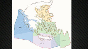
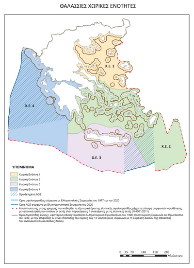
The Maritime Spatial Planning is an important strategic breakthrough in the spatial planning of the country, as for the first time the State defines and maps the uses and activities that can be developed across the entire range of maritime zones, while exercising its rights as provided for by the International Law of the Sea and Directive 2014/89/EU.
See the map with the Marine Spatial Planning:
The decision is based on the maritime delimitation agreement signed between Greece and Italy in 2020, which entered into force in 2021. It is also based on the International Law of the Sea, as provided for by the relevant 1982 UN Convention, which has been ratified by Greece since 1995.
The EEZ declared does not include the coastal zone (i.e. territorial waters), the extent of which has been defined by the 2021 law. However, within the EEZ Greece acquires full sovereign rights for the exploitation of natural resources, energy reserves and exploration.
The decree also provides that the country reserves to exercise similar rights in other areas of its coastline, always in accordance with the provisions of the Law of the Sea.
The declaration of the EEZ in the Ionian Sea is a decisive step in the exercise of national sovereign rights and is part of the broader framework of maritime spatial planning.
Hatzivassiliou: Greece protects the national interest with consistency and absolute respect for international law
“Greece is not afraid of dialogue and has absolute confidence in its positions, which are based on international law,” Deputy Minister of Foreign Affairs Tasos Hatzivassiliou said, speaking on the Greek government’s announcements on the Maritime Spatial Planning.
Specifically, speaking on Open on Good Friday morning, Mr.Hatzivassiliou noted that “the Turkish reaction was expected”, adding that “the Greek positions have been known for years“. As he stressed, “the maps are not directed against anyone – they depict the farthest potential boundaries of the Greek EEZ.“
This design, he stressed, “does not invalidate the rapprochement with Ankara, but on the contrary, it strengthens the transparency and institutional consistency of our country.” If we cannot find common ground with Turkey, then there is always the option of international jurisdiction, the Deputy Minister noted among other things.
Ask me anything
Explore related questions