With a lot of wind, the week has begun and will continue through May Day. According to weather forecasts the main feature of the weather for this week will be very strong northeast winds in the east onshore and the Aegean Sea reaching 5-7 and locally 8 to 9 Beaufort in the Aegean Sea at least until May Day.
Gradually the very strong winds will begin to fall from next Friday with a tendency to weaken towards the end of the week, as a result of which the temperature will begin to rise from May Day and then in the eastern parts, due to warmer air masses coming from the west.
Meteorologist Giorgos Tsatrafyllias explains that there are also six areas where wind gusts will exceed 100 km/h, potentially causing problems on land as well.
These are:
NE Aegean Sea,
Evia,
Attica,
Cyclades,
Eastern Peloponnese,
Chania.
No ferry leaves Rafina and Lavrio
A no sailing ban is in effect in many sea areas due to strong northerly winds in the sea.
From the port of Piraeus, ships will sail normally to Crete, while some routes to the Cyclades and islands of the eastern Aegean have been cancelled.
The routes to the Argosaronikos are being operated by some companies.
A ban is in force from the ports of Rafina and Lavrio.
The lines Ag.Marina-Nea Styra and Kavala-Prinos Thassos are also closed.
The services on the Volos Sporades line are operated with vessels of closed type.
Passengers intending to travel in the next few hours are advised to contact the local port authorities and tourist agencies before departure for any changes or modifications to the routes.
Trees have fallen in Attica
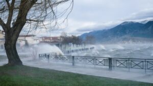
Significant problems were caused by the gusty winds blowing on Monday in many areas of the country, but also in Attica.
According to the Fire Department, there are numerous reports of fallen trees in Athens, many of which caused damage to vehicles and other infrastructure.
One of these incidents was recorded on Irini Avenue in Ilioupoli, with a tree falling and causing damage to a vehicle (taxi) and also to power lines of the PPC.
For this reason, the PPDIE was called to the spot – in addition to the Traffic Police and Fire Department – and the PPDIE.
Wind gusts of 134 km/h yesterday in Paximada Karystou
Gusty winds have been blowing since the early hours of Monday 28/04 in the eastern mainland and the Aegean Sea, with gusts of northerly winds exceeding 100 km/h.
According to the network of automatic weather stations of the National Observatory of Athens / meteo.gr, the highest maximum wind gust on Monday 28/04 occurred in Paximada Karystos with 134 km/h, while the eight highest maximum gusts are presented in the following Table.
An overview of the maximum gusts:
- Charisma: 134 km/h
- TinosGate: 111 km/h
- Carinthos: 103 km/h
- Penteli: 92 km/h
- Antikyra: 90 km/h
- Mykonos: 90 km/h
- Chalkida: 89 km/h
- Corinthos Isthmus: 84 km/h
At the same time, evima.gr published a video from Karystos and specifically from Bouros at Tsolias, demonstrating the intensity of the winds blowing in the area:
The weather today
A few clouds are forecast, increasing in the eastern and southern parts, with local showers or isolated thunderstorms in the Cyclades, Crete and the Southeastern Aegean, while there is a possibility of localized light showers in the eastern parts of Central Greece and the Peloponnese.
The temperature will range from 7 to 22 degrees in Northern Greece (in Western Macedonia from 4 to 18 degrees), 9 to 16 degrees in Central and Southern Greece, 11 to 23 degrees in Western Greece (in Epirus from 7 to 18 degrees), 11 to 19 degrees in the Cyclades and from 12 to 18 degrees in Crete, 10 to 22 degrees in the East Aegean islands and from 16 to 22 degrees in the Dodecanese.
The winds will blow in the Aegean from northerly directions strong to almost gusty 6-7 Beaufort, with the exception of the Southeastern Aegean where the winds will blow from variable directions light to moderate 3-5 Beaufort, while in the Ionian Sea from northeastern directions light to almost moderate 3-4 Beaufort and in the Central Ionian Sea moderate 4-5 Beaufort.
We expect a few clouds at times, with the possibility of localized light rain on Tuesday in Attica. The temperature will range from 11 to 16 degrees Celsius, but in the north and east it will be 2-3 degrees lower. Winds will blow from the north moderate to strong 5-6 Beaufort and in the east almost gusty 7 Beaufort.
We expect sunshine with thin clouds on Tuesday in Thessaloniki. The temperature will range from 11 to 21 degrees Celsius. The winds in Thermaikos will blow from variable directions, light.
The weather on Wednesday (30/04)
In the central and southern Aegean Sea and in the southern Peloponnese, clouds are forecast with local rain and possibly in the Dodecanese isolated thunderstorms. In the rest of the country, generally clear weather with thin clouds.
Winds will blow from the north in the west 3 to 5 Beaufort and in the east 5 to 7 Beaufort and in some places in the Aegean Sea 8 Beaufort.
The temperature will rise slightly.
The weather on May Day
In the Cyclades, Crete and the Dodecanese the weather will be unsettled with showers and isolated thunderstorms. In the rest of the country a few clouds will increase in the noon and afternoon hours in the northern mainland and local rain or isolated thunderstorms will occur mainly in central and eastern Macedonia.
Winds will blow from the north, in the west 4 to 6 and in the east 5 to 7 and locally in the Aegean Sea 8 Beaufort.
The temperature will rise slightly further, mainly in the west and north.
The weather on Friday (02/05)
In Crete, the eastern Cyclades and the Dodecanese the weather will be unsettled with showers and occasional thunderstorms and weakening from the evening. In the rest of the country there will be a few clouds, which will increase in the midday and afternoon hours and there will be local rain in the mainland and isolated thunderstorms in the mountains.
Winds will blow from the north, in the west 3 to 5 Beaufort and locally in the Ionian Sea 6 Beaufort and in the east 5 to 7 Beaufort and in the Aegean Sea in some places occasionally in the morning hours 8 Beaufort.
The temperature will not change significantly.
The weather on Saturday (03/05)
In Crete, partly cloudy with local rain until the afternoon. In the rest of the country, generally clear weather.
Winds will blow from the north, in the west 3 to 5 and locally in the Ionian Sea 6 Beaufort and in the east 5 to 6 and locally in the Aegean Sea 7 Beaufort.
The temperature will rise slightly.
Ask me anything
Explore related questions