
This week’s weather will feel like summer, with temperatures climbing to around 30°C, according to meteorologists. Yesterday, in some areas, temperatures already surpassed that mark. This rise will be accompanied by African dust, and as meteorologist Thodoris Kolydas noted, a cold front is expected to follow the warm air mass, bringing a notable drop in temperatures below seasonal norms.
“After the cold days of this past April, especially following Easter in the Aegean islands, we’re now seeing slightly above-average temperatures,” Kolydas explained. However, he warned that a cold air mass is expected starting Friday and over the weekend, leading to below-average temperatures.
🎯Η ΜΕΣΟΠΡΟΘΕΣΜΗ ΠΡΟΓΝΩΣΗ ΤΟΥ ΚΑΙΡΟΥ
— Theodoros Kolydas (@KolydasT) May 4, 2025
✅Μετά τις κρύες ημέρες που προηγήθηκαν τον φετινό Απρίλιο σε όλη την χώρα και ειδικά μετά το Πάσχα στα νησιά του Αιγαίου, έρχονται θερμοκρασίες λίγο πάνω από τα κανονικά επίπεδα. Ποιά θα είναι η πορεία του καιρού τις επόμενες ημέρες;
✅Η… pic.twitter.com/AxLFayFozG
Kolydas also commented on yesterday’s highs:
“Today, as the warm air advection hasn’t fully completed yet – due to the southwest winds (Livas) – temperatures reached 32.7°C in Karditsa, 32°C in Farsala, 31°C in Larissa, and 31°C in Psachna, Evia. Next week, southerly downslope winds in northern Crete will play a key role.”
Heat Wave Confirmed on May 4
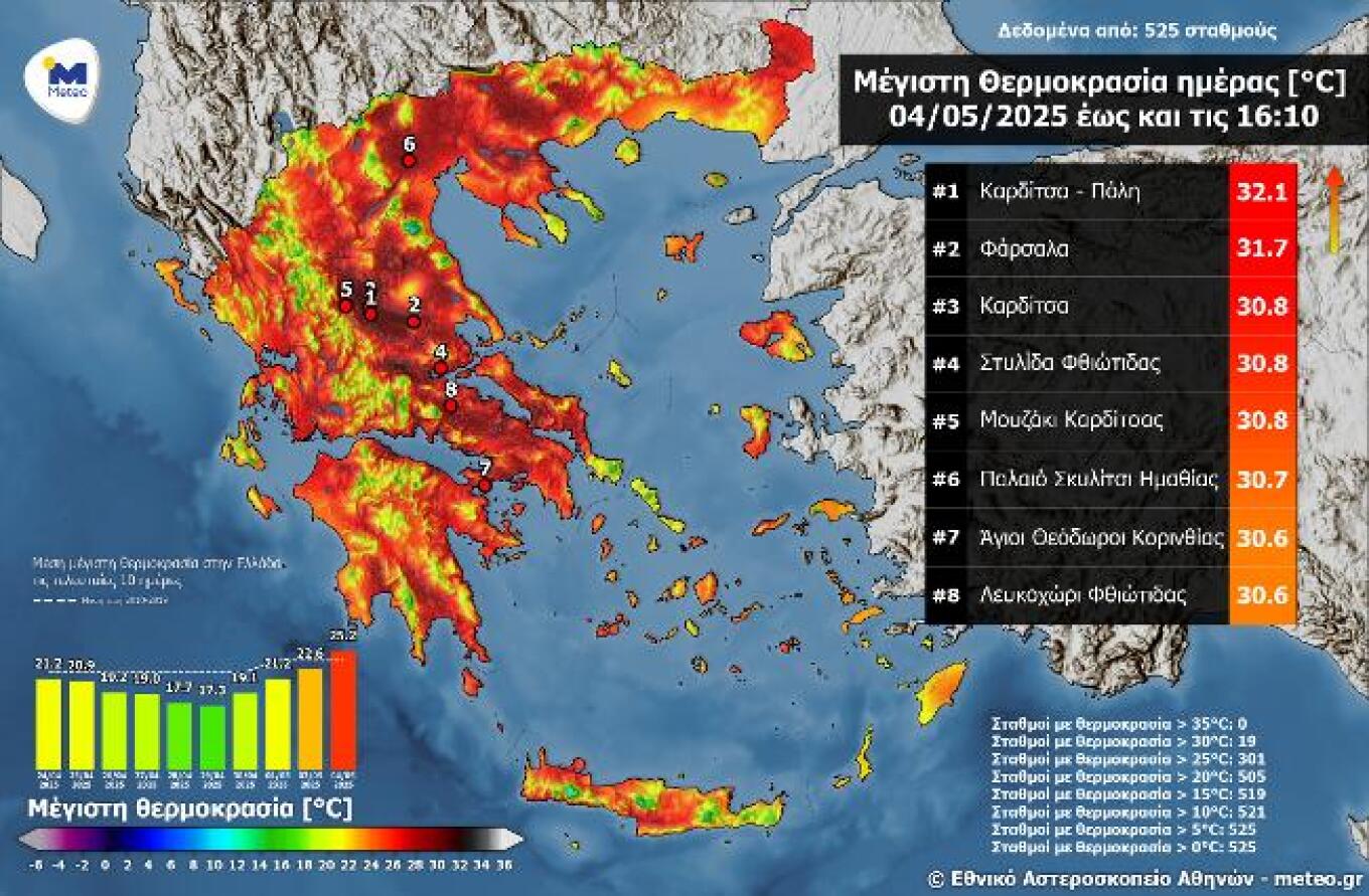
Sunday, May 4, recorded the highest average maximum temperature in the last 10 days. Based on the National Observatory of Athens’ automated weather stations, 301 stations recorded highs above 25°C, with Karditsa peaking at 32.1°C.
Weather Today (Monday)
- Forecast: Mostly sunny with some clouds, thickening in the west and later spreading. Scattered showers or isolated storms in the Ionian, Epirus, and western mainland early on; later in Thessaly, western Macedonia, and central Greece mountains. These will fade by midday.
- Temperatures:
- Northern Greece: 11–27°C (Western Macedonia: 10–24°C)
- Central/Southern Greece: 14–29°C
- Western Greece: 13–25°C
- Cyclades: 12–23°C
- Crete: 13–29°C
- Eastern Aegean: 12–26°C
- Dodecanese: 15–23°C
- Winds:
- North/Central Aegean: Light and variable
- South Aegean: Westerlies, moderate (4–5 Beaufort)
- Ionian Sea: Southerlies, light to nearly moderate
- Corinthian Gulf: Westerlies, moderate (4–5 Beaufort)
Athens:
- Sunny with a few clouds, becoming thicker at times.
- 17–29°C (cooler in northern/coastal suburbs).
- Light, variable winds; briefly NW at 4 Beaufort in the morning and evening.
Thessaloniki:
- Sunny with occasional increased cloudiness.
- 16–26°C.
- Light, variable winds in the Thermaic Gulf.
Tuesday, May 6
- More cloud and local showers/storms expected in northern Ionian, Epirus, Thessaly, Macedonia, and parts of Central Greece, especially by afternoon.
- Elsewhere, mostly clear with some passing clouds.
- African dust transport conditions favorable.
- Winds: Southerly, 4–5 Beaufort; up to 6 Beaufort in seas.
- Temperatures: Slight rise in central/southern regions.
- Northern mainland, Ionian, most Aegean: 24–26°C
- Elsewhere: 27–29°C
Wednesday, May 7
- Northern Greece: Increased clouds with local rain/storms in the afternoon.
- Rest of country: Light to locally dense clouds.
- African dust likely persists.
- Winds: Southerlies, 4–5 Beaufort; locally 6 at sea. Turning NW in the west by evening.
- Temperatures: Rise continues, especially in central and southern areas – well above seasonal averages.
Thursday, May 8 & Friday, May 9
- Scattered clouds, sometimes denser. Localized showers or isolated thunderstorms in northern mainland areas in the afternoon.
- African dust still present.
- Winds:
- West: Northerlies 3–5 Beaufort
- East: Southerlies 4–6 Beaufort
- Temperatures: No significant change.
Ask me anything
Explore related questions


