Rain and storms lasting until early morning hours, strong local northern winds, and a drop in temperature are the main weather features today. According to meteorological forecasts, the weather change that has affected the country since yesterday afternoon has significantly helped to clear out African dust, and conditions are expected to improve in most regions by midday.

However, the severe weather that hit the country yesterday caused several issues in Crete, Lamia, and Attica.
Due to heavy rainfall late Sunday night, Koropi Avenue in Markopoulo became impassable, with many cars stranded and drivers calling the Fire Department.
Around midnight, continuous rain caused flooding in several areas. The fire department received at least 17 calls to pump water in northeastern Attica, especially in the municipalities of Marathon, Rafina, Pikermi, and Penteli.
According to Meteo, rainfall occurred late Sunday in Agia Paraskevi, Pallini, Papagou, Marousi, Kantza, Vyronas, Spata, Nea Makri, Penteli, Rafina, Koropi, Gerakas, and Markopoulo.
Rain was also recorded in Naxos, Skyros, Ikaria, parts of Evia, Boeotia, Chalkidiki, Thasos, Drama, and Alexandroupolis.
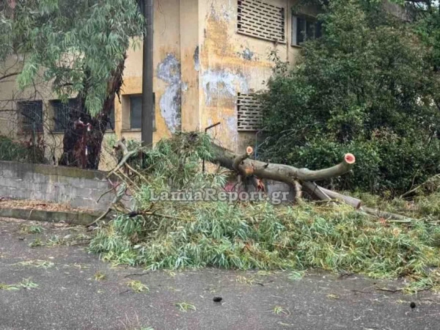
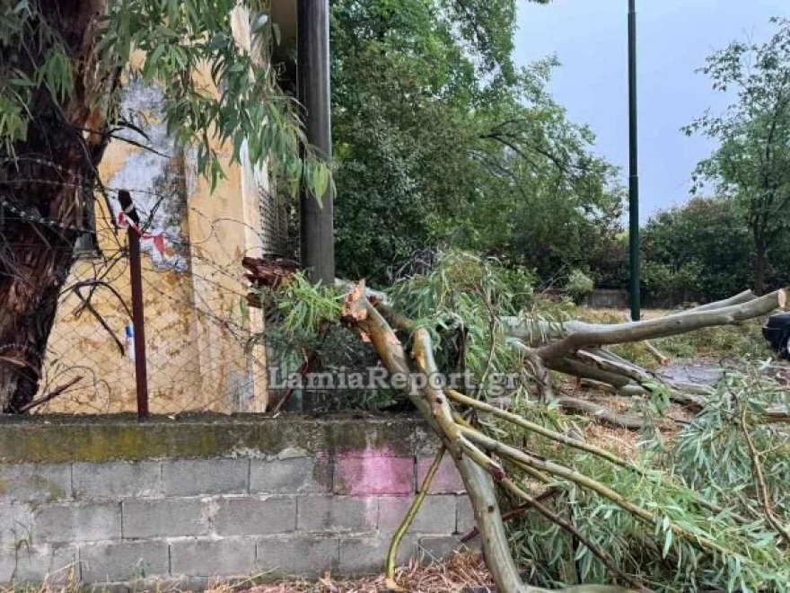
Heavy rain hit the city of Lamia, and strong winds brought down numerous trees, even within the city. Power outages occurred in the southern part of Lamia, leaving hundreds of households without electricity for more than two hours.
The fire department received many calls to pump water, especially from southern neighborhoods, while the Traffic Police restricted access to streams that had dangerously overflowed and were impassable for cars and people.

Problems in Crete
In Crete, strong southern winds caused significant damage, toppling trees, DEI poles, and even a football goalpost. The winds also affected flights at the Heraklion and Chania airports, causing passenger disruptions.
Kissamos Municipal Stadium did not escape the strong winds either. The Kastelli stadium, exposed by the sea, sustained infrastructure damage, including a collapsed goalpost and a high jump mat blown dozens of meters away.
More than ten aircraft could not land at Heraklion Airport on Sunday. In Chania, a flight from Frankfurt was diverted to Athens and finally arrived with a four-hour delay. Delays were also observed for other arriving flights.
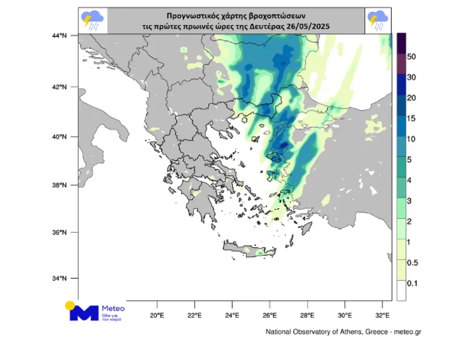
Rainfall Map
Heavy rain and thunderstorms occurred in Central Greece, northeastern Peloponnese, Thessaly, Evia, Central and Eastern Macedonia, and later in the Sporades, Thrace, the northern Aegean, and gradually in the eastern Aegean.
Thunderstorms with over 12,000 lightning strikes
According to Meteo, Sunday’s storms included significant electrical activity. The Meteosat-12 meteorological satellite’s Lightning Imager recorded 12,664 lightning strikes over Greece from the start of the day until 21:40 local time.
Electrical discharges include lightning strikes (cloud-to-ground), cloud-to-cloud discharges, and cloud-to-air discharges.
Rainfall totals as of 22:00:
- Perithori (Nevrokopi): 40.4 mm
- Neo Monastiri (Fthiotida): 38.4 mm
- Nevrokopi: 36.4 mm
- Farsala: 33.2 mm
- Xanthi: 30.4 mm
- Sesi Parnassou: 29.2 mm
- Makrinitsa: 29.2 mm
- Smokovo (Karditsa): 28 mm
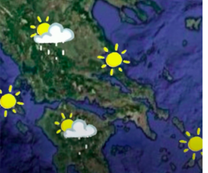
EMY Forecast: Weather today (Monday)
Eastern Macedonia, Thrace, Northeastern Aegean Islands:
Rain and scattered, locally strong storms early in the morning with quick improvement.
Rest of the country:
Mostly clear weather, except some local rain in the eastern Aegean and Dodecanese early, and northern Crete by noon.
Winds:
North to northwest 4–6 Beaufort, locally 7 in the Ionian early in the day.
Temperatures:
Lower across the country, reaching 22–24°C in the north and 24–26°C elsewhere.
Regional forecasts
Macedonia, Thrace:
Cloudy early in the east with rain/storms, quickly improving.
Winds: NW 3–5 Beaufort, locally 6 in central Macedonia.
Temperature: 11–24°C (2–3°C lower in western Macedonia).
Ionian Islands, Epirus, Western Greece, Western Peloponnese:
Mostly clear weather.
Winds: NW 5–6 Beaufort, locally 7 in the Ionian early.
Temperature: 14–26°C (lower in Epirus inland).
Eastern Greece, Evia, Eastern Peloponnese:
Mostly clear weather.
Winds: N 3–5 Beaufort.
Temperature: 15–26°C.
Cyclades, Crete:
Clear in Cyclades, local clouds in Crete with northern rain at noon.
Winds: N 3–5 Beaufort, locally 6 in Cyclades early.
Temperature: 15–25°C.
Eastern Aegean Islands, Dodecanese:
Clouds with local storms early in the northeast, quickly improving.
Further south: local rain early, then clear.
Winds: NW 4–5, locally 6 Beaufort.
Temperature: 18–25°C (cooler in the north).
Thessaly:
Mostly clear weather.
Winds: NW 3–5 Beaufort, locally 6 in Sporades early.
Temperature: 12–26°C.
Weather in Athens and Thessaloniki
Athens:
Clear. Winds: variable 3–4 Beaufort. Temp: 16–26°C.
Thessaloniki:
Clear. Winds: NW 4–5 Beaufort, locally 6 in Thermaikos early. Temp: 12–22°C.
Tuesday, May 27, 2025
Few clouds, more in the afternoon over mainland and mountains, with local rain and isolated storms in the north.
Winds: W/NW 3–5, up to 6 Beaufort in the south.
Temperature: slight rise, 26–28°C in the east, 24–26°C elsewhere.
Wednesday, May 28, 2025
Few clouds, increasing in the afternoon in mainland and mountainous Crete, with scattered showers/storms.
Winds: NW 3–5, up to 6 Beaufort in the south.
Temperature: no significant change.
Thursday, May 29, 2025
Increased clouds in Eastern Macedonia/Thrace in the morning; clouds increase from noon in mainland, Crete mountains, and Ionian. Local rain and storms. In the evening, clouds and storms spread to Cyclades and Sporades.
Winds: NW 3–5 Beaufort.
Temperature: no significant change.
Friday, May 30, 2025
Clouds and storms in the east, easing by evening in most areas except Crete and Dodecanese. Elsewhere, local rain and isolated storms over mainland mountains.
Winds: N/NW 3–5, locally 6 Beaufort in Ionian.
Temperature: slight drop.
Ask me anything
Explore related questions