
The weather will remain warm with meltemia winds through Sunday, with no significant change in temperature. The conditions will remain summery over the coming days, as noted in a post by Klearchos Marousakis.
The OPEN meteorologist also shared a map illustrating the differences between cold and warm air masses, as well as what is expected in Greece.
“When the meltemia winds in the Aegean strengthen, thermal instability decreases. When they weaken, thermal instability increases over the mountains and surrounding areas. With the current atmospheric circulation that we have just analyzed, the following days in our country will unfold, shaping the classic Greek summer,” he explained.
High Fire Risk Today in 10 Areas
A high fire risk (risk category 3) is forecasted today in certain parts of the country, according to the Fire Risk Forecast Map issued by the General Secretariat for Civil Protection of the Ministry of Climate Crisis & Civil Protection (civilprotection.gov.gr).
High risk category 3️⃣ in:
- Attica & southern Euboea
- Crete
- Dodecanese, Cyclades
- Lesbos, Chios, Psara, Samos, Ikaria
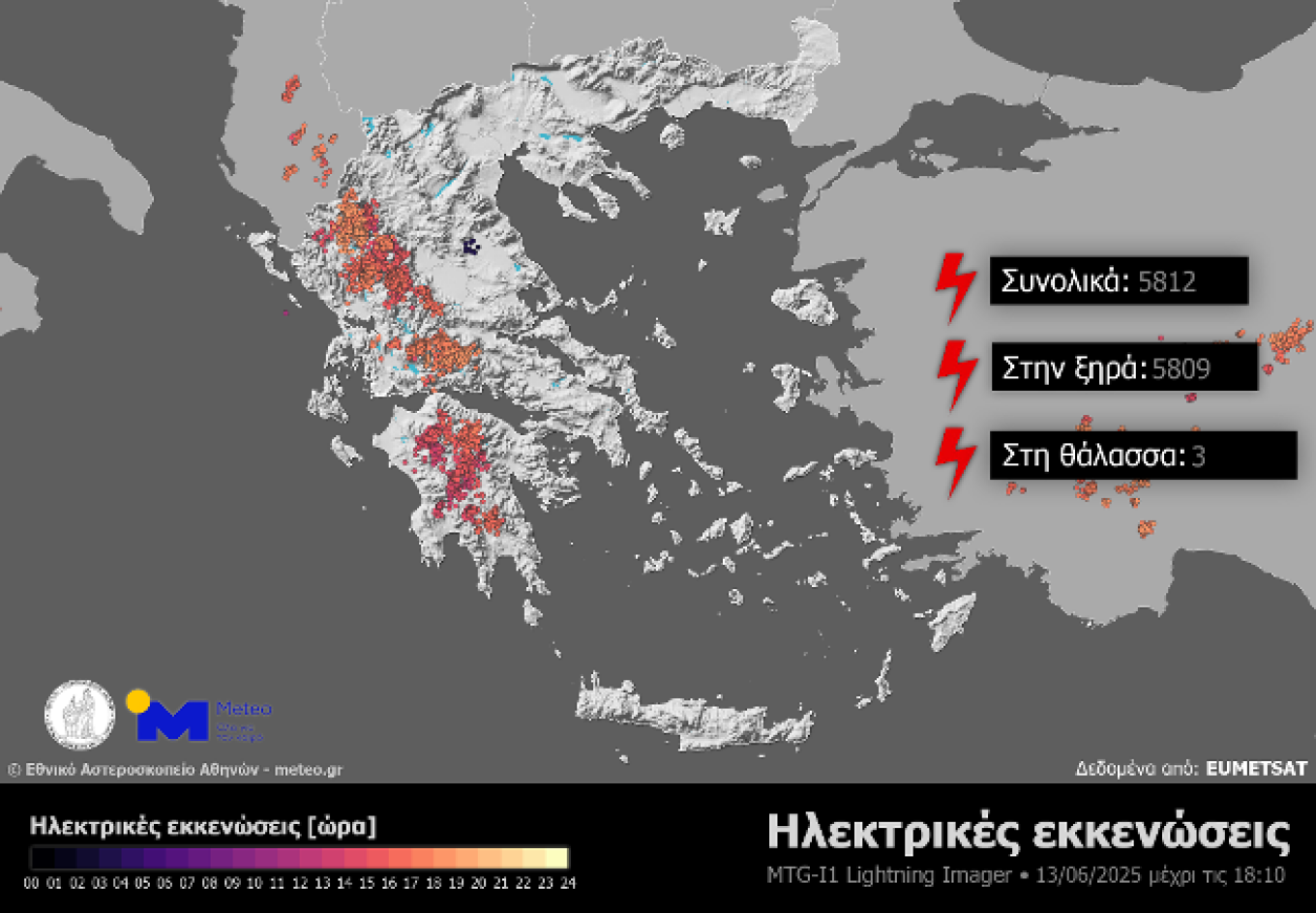
Nearly 6,000 Lightning Strikes on Friday 13/06
Local showers and thunderstorms occurred mainly in mountainous areas of Epirus, Western Central Greece, and the Peloponnese on Friday, June 13. Data analysis from the third-generation European meteorological satellite Meteosat-12 and its Lightning Imager (LI) instrument showed that by 18:10 on Friday 13/06, nearly 6,000 lightning strikes had been recorded.
Note that lightning strikes include both cloud-to-ground strikes (lightning), intra-cloud discharges, and discharges between clouds and the surrounding air.
Today’s Weather
Generally clear weather is expected, with local showers and thunderstorms during midday and afternoon hours, mainly over the mountainous areas of the Peloponnese, Eastern Macedonia, and Thrace.
Temperatures will range:
- In Western Macedonia: 12 to 29-30°C
- In the rest of Macedonia and Thrace: 13 to 32-34°C
- In Thessaly: 12 to 33°C
- In Epirus: 12 to 33°C
- In other mainland areas: 13 to 33-35°C
- In the Ionian Islands: 16 to 32°C
- In the Aegean islands and Crete: 15 to 32-34°C (locally in Rhodes and Crete up to 35-36°C)
Winds in the Aegean will blow mostly from northern directions at 5-6 Beaufort, locally up to 7 Beaufort in the southeastern Aegean. In the Ionian, winds will be generally northwesterly at 4-5 Beaufort.
In Attica, generally clear weather is expected. Winds will blow from northern directions at 3-4 Beaufort, locally reaching up to 5 Beaufort in the eastern parts of the region. Temperatures will range from 24 to 32-33°C.
In Thessaloniki, generally clear weather is also expected. Winds will blow from various directions at 2-3 Beaufort. Temperatures will range from 23 to 32-33°C.
Weather on Sunday, June 15
Generally clear weather, though during midday and afternoon hours, clouds will develop in some mainland areas, and in the western and northern mountainous and semi-mountainous regions, local showers may occur.
Winds will be light and variable in the west. In the east, they will blow from northern directions at 4 to 6 Beaufort, reaching 7 to 8 Beaufort in the eastern Aegean.
Temperatures will drop slightly across the country, reaching 30-32°C on the mainland, 28-30°C in the Ionian Islands, southern Crete, and the Dodecanese, and 26-28°C in other island regions.
Weather on Monday, June 16
Generally clear weather, with a few temporary clouds in some mainland areas during midday and afternoon hours. In the western and northern mountainous regions, local showers may occur. Visibility will be locally limited in the west early in the morning.
Winds will be light and variable in the west. In the east, they will blow from northern directions at 4 to 5 Beaufort, and in the southeastern Aegean at 6 to 7 Beaufort.
Temperatures will remain relatively stable.
Ask me anything
Explore related questions