×
GreekEnglish

×
  • Politics
  • Diaspora
  • World
  • Lifestyle
  • Travel
  • Culture
  • Sports
  • Cooking
Tuesday
23
Jun 2026
weather symbol
Athens 29°C
  • Home
  • Politics
  • Economy
  • World
  • Diaspora
  • Lifestyle
  • Travel
  • Culture
  • Sports
  • Mediterranean Cooking
  • Weather
Contact follow Protothema:
Powered by Cloudevo
> Greece

Meteo: Nearly 42 kilometers burned by wildfires in Kryoneri (Attica), Kythera, and Evia – See satellite images from Kythera, Evia, and Attica

Analysis of satellite data from the European Copernicus EMS mechanism, as of 12:20 p.m. on Sunday

Newsroom July 28 02:01

Δείτε περισσότερα άρθρα μας στα αποτελέσματα αναζήτησης

Add Protothema.gr on Google

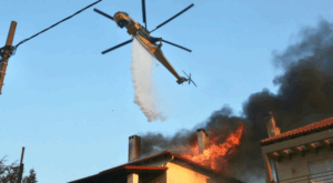
High-resolution satellite data from the WorldView-2 satellite (VHR2 sensor), which passed over the affected areas at noon on Sunday, July 27, 2025, was processed by the team at meteo.gr / National Observatory of Athens, revealing the extent of the areas impacted by the recent forest fires in Kythera, Pissonas in Evia, and Kryoneri in Attica.

According to the analysis of satellite data from the European Copernicus EMS mechanism, as of 12:20 p.m. on Sunday, approximately:

>Related articles

Magnitude 4.0 earthquake in Evia felt across parts of Attica

Airbnb: New rules take effect from July 1 – Race for permits, sales and property transfers

Inauguration of the New State-of-the-Art Cyber Defence Center at the Pentagon in a 2,500-Square-Meter Building, Donated by the Athanasios Laskaridis Foundation

  • 26,880 stremmata (2,688 hectares) were burned in Kythera
  • 12,810 stremmata (1,281 hectares) in Pissonas, Evia
  • 2,269 stremmata (226.9 hectares) in Kryoneri, Attica

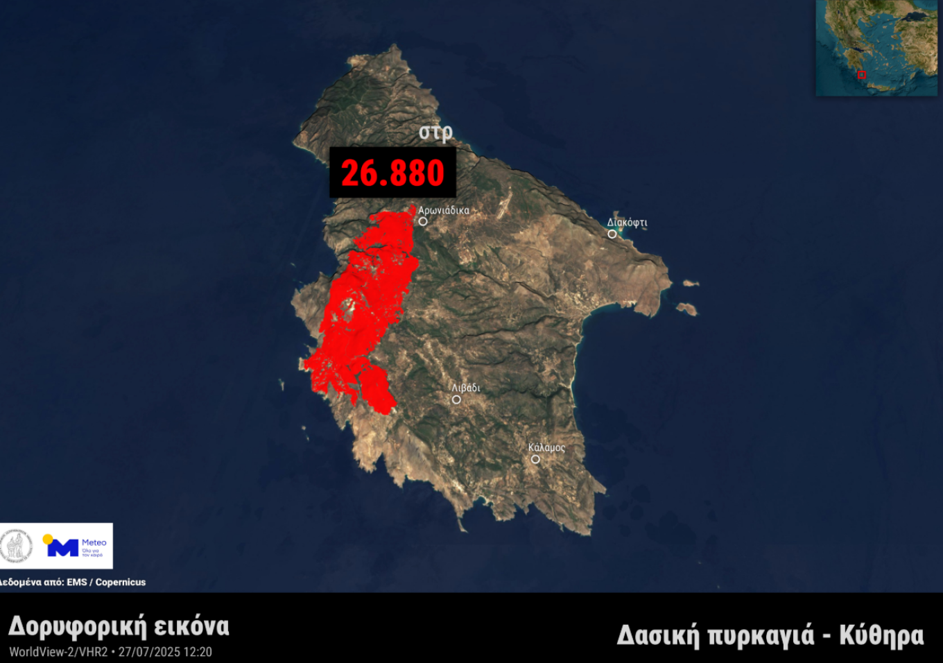
Image 1: Burned area from the forest fire in Kythera, based on satellite data from the EMS / Copernicus service as of noon, Sunday, July 27, 2025.

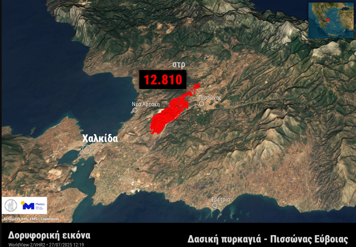
Image 2: Burned area from the forest fire in Pissonas, Evia, based on satellite data from the EMS / Copernicus service as of noon, Sunday, July 27, 2025.

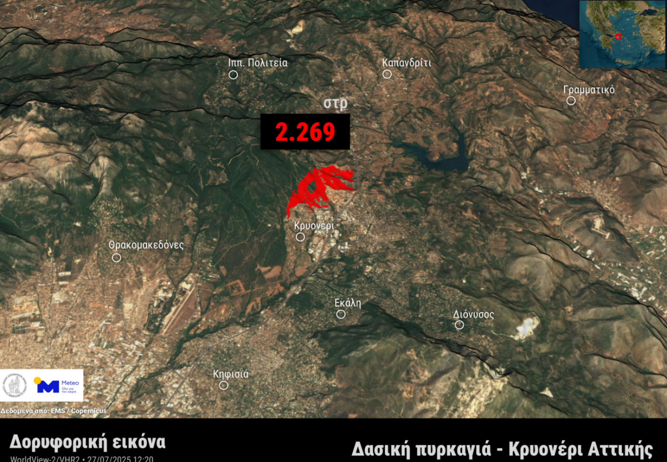
Image 3: Burned area from the forest fire in Kryoneri, Attica, based on satellite data from the EMS / Copernicus service as of noon, Sunday, July 27, 2025.

Ask me anything

Explore related questions

#attica#Evia#fire#fires#greece#Kythera#wildfire
> More Greece

Follow en.protothema.gr on Google News and be the first to know all the news

See all the latest News from Greece and the World, the moment they happen, at en.protothema.gr

> Latest Stories

Traffic restrictions in central Athens and Kallithea today for SNF Nostos Run 2026

June 23, 2026

Temperatures to reach 35 Celsius in Greece as mainland showers and Aegean winds shape the week

June 23, 2026

Avramopoulos case file goes to Greek parliament today as Belgian warrant raises questions over Qatargate link

June 23, 2026

A “digital shield” against hybrid threats: Greece inaugurates new Cyberspace Building to protect critical infrastructure

June 23, 2026

Iran says Strait of Hormuz ‘will never return to pre-war conditions’ despite US sanctions relief

June 23, 2026

11 Restaurants in Milos, Chosen by People Who Go Every Summer

June 23, 2026

Moving to Greece from abroad? New AADE rules explain who can avoid customs duties, VAT and car registration fees

June 23, 2026

Alexis Tsipras to unveil shadow cabinet as SYRIZA deadline over support for his ELAS party expires

June 23, 2026
All News

> Greece

In reverence, the emotional deposition in Jerusalem, see photos & video

The Holy Temple of the Resurrection opened after many days due to the war between Israel and Iran

April 10, 2026

In the final stretch for the accreditation of joint master’s degrees: Aiming for their launch in the coming academic year

April 10, 2026

Schedule for Epitaph Procession today (10/4)

April 10, 2026

Perfect weather for Easter excursions, according to Tsatrafyllia’s forecast

April 10, 2026

Easter in Greece: The customs that continue in Greek tradition – From Nafpaktos to Corfu

April 10, 2026
Homepage
PERSONAL DATA PROTECTION POLICY COOKIES POLICY TERM OF USE
Powered by Cloudevo
Copyright © 2026 Πρώτο Θέμα