
Starting today, high temperatures will begin to gradually subside, beginning in western Greece and extending to the rest of the country by tomorrow. However, heatwave conditions are still expected for a few more hours in parts of central and eastern Greece, according to the Hellenic National Meteorological Service (EMY).
Meteorologist Sakis Arnaoutoglou forecasts rain on Tuesday, July 29 in Epirus, the northern Ionian and western mainland Greece, on Wednesday, July 30 in eastern Macedonia and Thrace, and on Thursday, July 31 even in the mountainous regions of Attica.
According to meteorologist Giorgos Tsatrafyllias, starting Tuesday and throughout the week, typical July heat will prevail, along with a return of moderate atmospheric instability. He also notes that long-range forecasts from seven different weather centers indicate a hotter-than-average August, with more than a 70% likelihood.
Kolyvas: Heatwave to End Tuesday, Cooling in the Ionian and Western Mainland
Meteorologist Theodoros Kolyvas also predicts that the heatwave will subside by Tuesday. Cooling began Saturday in western Greece and will continue spreading across the country. Localized rain is also expected in the Ionian and western mainland regions, according to the Star Channel’s forecast.
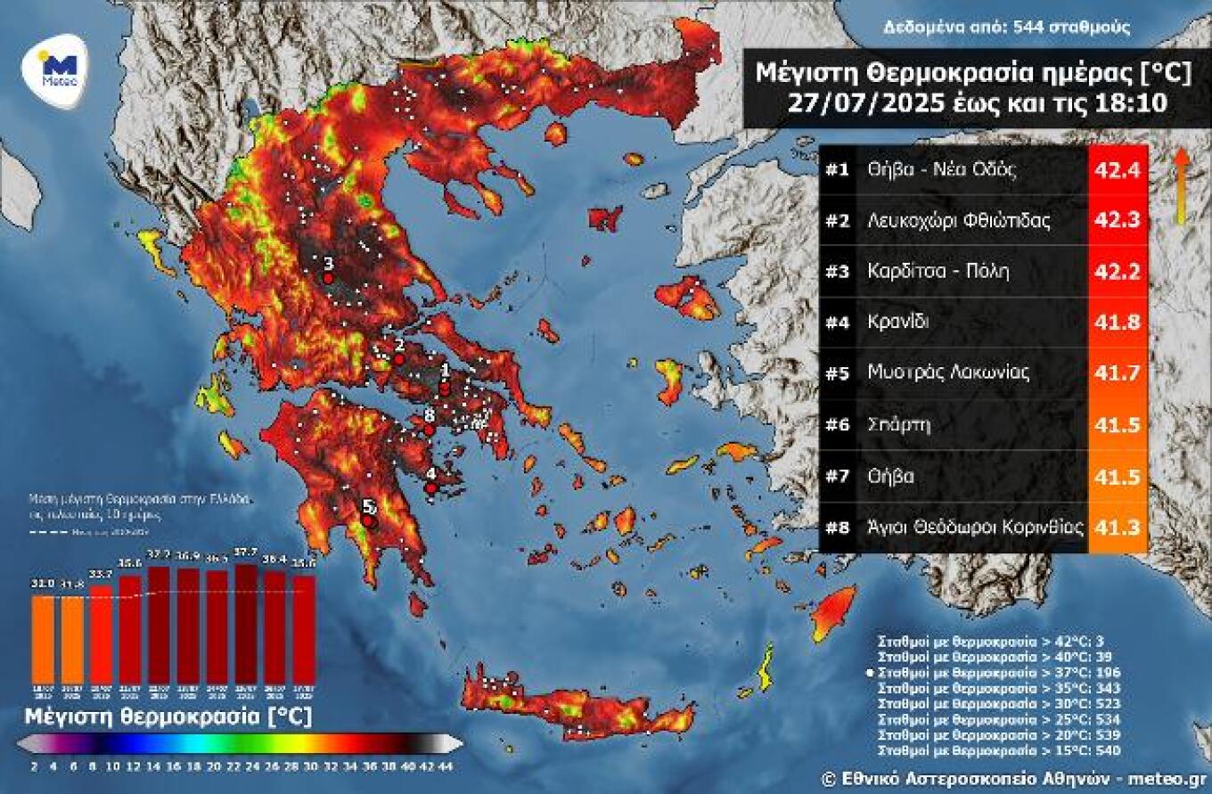
Sunday, July 27: Temperatures Hit 42°C
Heatwave conditions continued on Sunday, July 27, with temperatures reaching 40–42°C in many areas. According to the automatic weather station network of the National Observatory of Athens / meteo.gr, the highest temperatures were recorded in the Peloponnese and Eastern Central Greece.
A temperature distribution map showed 196 out of 544 active weather stations recorded temperatures above 37°C, 39 stations exceeded 40°C, and 3 stations reached 42°C. The national average maximum temperature was 35.6°C.
In the region of Attica, and particularly in Athens, maximum temperatures exceeded 39–40°C in several locations: SKA (40.0°C), Zephyri (39.9°C), and Salamina (39.8°C). Notably, a temperature drop of up to 10°C was recorded in Western Greece compared to Saturday, July 26.
Today’s Weather Forecast
Clear skies with few local clouds will prevail. Heatwave conditions will persist in some central and eastern regions.
Temperatures:
- Western Macedonia: 16–33°C
- Rest of Macedonia and Thrace: 22–36/37°C, locally up to 39°C in Thrace
- Thessaly: 22–38/39°C, locally up to 40–41°C
- Epirus: 20–31°C
- Rest of Western Greece: 22–33°C
- Other mainland areas: 25–35/37°C, locally up to 38°C
- Ionian Islands: 21–31°C
- Aegean Islands and Crete: 22–33/34°C, locally up to 38°C in eastern Aegean and Crete
Winds:
- North Aegean: West winds 4–5 Beaufort, turning southward during midday
- South Aegean: Westerly winds 5–6, locally 7 Beaufort
- Ionian Sea: Initially northwest winds 5–6 Beaufort, shifting westward with slight weakening by noon
- Corinthian Gulf: Strong westerly winds up to 6 Beaufort
In Athens, sunny and hot weather is expected. Winds from the west-northwest at up to 5 Beaufort, locally 6 in the west and open sea areas of the Saronic Gulf. Temperatures will range from 28 to 36–38°C.
In Thessaloniki, sunny weather with northwest winds 3–5 Beaufort. Temperatures from 27 to 35–36°C.
Tuesday, July 29 Forecast
Clouds and local showers or thunderstorms are expected in the Ionian and western mainland regions from the morning. Gradually, cloudiness will increase in central and northern mainland areas, with possible afternoon showers. The rest of the country will remain mostly clear.
Winds: Westerly 3–5 Beaufort, up to 6 in southern seas. Northeastern areas may see southerly winds up to 4 Beaufort.
Temperatures will drop slightly, especially in eastern mainland areas, where they’ll reach 35–37°C.
Wednesday, July 30 Forecast
Generally fair weather, with some local clouds forming by late morning in the north and, later, in other central and eastern mainland regions. Localized showers or storms are possible in the north.
Winds: Northwest 3–5 Beaufort, up to 6 in the west and south.
Temperatures will remain stable.
Thursday, July 31 Forecast
Unstable weather with rain and scattered thunderstorms—potentially strong in places—initially in the north, then spreading to central mainland areas, the Sporades, and Evia. Rainfall will continue in eastern Thessaly, Macedonia, and Thrace into the evening. The rest of the country will remain mostly clear.
Visibility will be locally reduced in the Ionian and western mountainous mainland during the morning.
Winds: Northerly 4–5 Beaufort, up to 6–7 locally in the west and south.
Temperatures will drop slightly.
Friday, August 1 Forecast
Initially unstable weather with local rain and possibly isolated storms in the Sporades and later, by midday to afternoon, across the mainland. Conditions will improve by nightfall. The rest of the country will experience clear skies.
Morning visibility may be limited in the Ionian and western highlands.
Winds: Northerly 4–5 Beaufort, up to 6 in the seas.
Temperatures will remain stable.
Ask me anything
Explore related questions