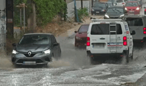
According to reports, rain has been recorded in many northern suburbs of Athens, including Agia Paraskevi, Pallini, Spata, Marousi, Kifisia, and Chalandri, as well as in areas closer to the city center, such as Nea Ionia.
Some areas, like Menidi, are already seeing traffic disruptions due to water pooling on the roads.
Video footage from rainy Attica has emerged, highlighting the shift in weather.
Rain Also Affecting Central Greece, Thessaly & Macedonia
According to data from meteo.gr, rain is falling in other parts of the country as well—specifically in Central Greece (Kopaida, Fthiotida, Livadeia), Thessaly (Karditsa, Farsala, Anavra, Larissa), Epirus (Ioannina), and large parts of Macedonia (Thessaloniki, Grevena, Kilkis, Serres, Halkidiki, and others).
New Severe Weather Alert Issued by EMY
Greece’s National Meteorological Service (EMY) has issued a new urgent weather bulletin warning of a temporary worsening of conditions in northern and central parts of the country. The forecast includes heavy rain and thunderstorms, with some areas expected to experience hail and strong winds.
The updated warning outlines:
- Central Macedonia (especially Thessaloniki, Halkidiki, Kilkis) and Eastern Macedonia will face storms lasting into the night.
- Western Macedonia, mountainous areas in Epirus, and Thrace will see afternoon thunderstorms.
- Sporades islands are expected to have rain until early afternoon.
- Thessaly (particularly Karditsa and Trikala) will experience storms from late morning until early evening.
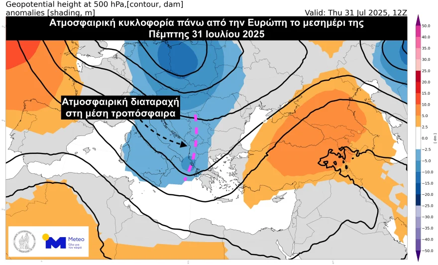
Thursday, July 31, 2025: Local Storms Expected Across Much of Greece
According to the latest forecast from the National Observatory of Athens (meteo.gr), the shift in weather is due to a mid-level atmospheric disturbance moving from Italy toward the southern Balkans and Greece.
Forecast highlights for Thursday:
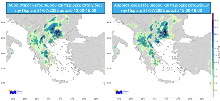
- Rain and thunderstorms are expected in Macedonia, Thessaly, Central Greece, and parts of Thrace, Epirus, and Northern Peloponnese.
- In the evening, storms may spread to parts of the Northern Aegean.
- Some of these storms may be intense, bringing gusty winds and small hail.
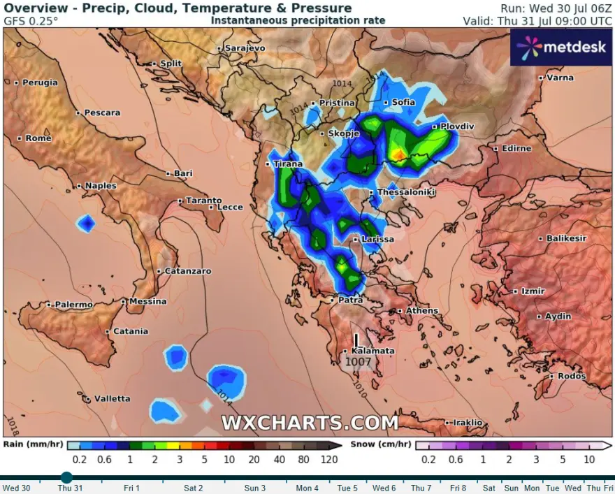
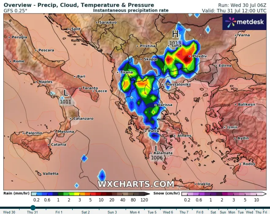
Weather maps from the Global Forecast System (GFS) show precipitation and storm zones for the hours between 12:00–18:00.
Civil Protection Guidelines for Citizens
Greece’s Civil Protection Authority is urging the public to take precautions against severe weather. Relevant government bodies and local authorities have been placed on high alert to manage possible flood or storm-related incidents.
Recommended safety tips include:
- Secure loose objects that could be blown away by strong winds.
- Make sure gutters and drains are clear.
- Avoid crossing flooded roads or rivers, whether on foot or by vehicle.
- Refrain from outdoor work or coastal activities during storms.
- Take shelter immediately during hailstorms—in a building or a car.
- Stay away from large trees, hanging signs, balconies, and lightweight structures.
- Follow instructions from local authorities (e.g., police, emergency services).
If there’s lightning activity:
At home:
- Avoid using wired electronics or phones.
- Disconnect TVs from antennas and power outlets.
- Do not touch plumbing fixtures.
In your car:
- Pull over away from trees and power lines.
- Stay inside with hazard lights on.
- Keep windows closed and avoid contact with metal surfaces.
Outdoors:
- Seek shelter in a building or car. If that’s not possible, crouch low to the ground without lying down.
- Avoid high ground, rivers, lakes, or the sea.
- Never shelter under tall isolated trees.
- Stay away from metal objects and fences.
Emergency Info:
- For road closures or flood updates: www.astynomia.gr
- For protection tips and updates: civilprotection.gov.gr
Current Conditions in Attica
Light rain is expected across northern Attica from midday onward. Temperatures will reach up to 31°C with light winds (up to 3 on the Beaufort scale).
Rain is expected to begin around 3 PM, potentially turning into a thunderstorm at times.
Today’s National Weather Outlook
Showers and thunderstorms will affect inland regions and later spread to parts of the Northern Aegean. Storms in central and northern Greece may be accompanied by strong winds and small hail. Southern island regions and the Ionian Sea will likely remain sunny and stable.
Temperatures:
- Western Macedonia: 14–27°C
- Eastern Macedonia & Thrace: 15–35°C
- Thessaly: 15–32°C
- Epirus: 13–32°C
- Western Greece: 14–33°C
- Rest of mainland: 14–34°C
- Ionian Islands: 19–30°C
- Aegean Islands & Crete: 18–33°C
Winds:
- Northwesterly, 4–6 Beaufort, locally stronger in the Aegean.
Regional Highlights
Attica:
Scattered rain and possible thunderstorms in the afternoon. Winds northwesterly at 2–3 Beaufort, temporarily reaching 4–5 in eastern areas. Temperatures: 26–34°C.
Thessaloniki:
Rain and thunderstorms expected. Light northwesterly winds (2–3 Beaufort). Temperatures: 23–28°C.
Friday, August 1 Forecast
Clouds, scattered showers, and isolated storms in Eastern Macedonia, Thrace, Sporades, and Evia in the morning, clearing by evening. Mostly sunny elsewhere, with possible afternoon showers in mountainous inland areas and Crete.
Winds: Northerly, 4–6 Beaufort, reaching 7 in the Aegean.
Temperature: Stable, ranging from 31–35°C in most areas.
Saturday, August 2 Forecast
Passing morning clouds in the Sporades and Evia, clearing later. Mostly sunny elsewhere, but inland areas may see afternoon showers and isolated storms in the north.
Winds: Northwest, 3–7 Beaufort.
Temperature: No significant change.
Sunday, August 3 Forecast
Generally clear across the country, with some afternoon cloud buildup and local showers possible in mountainous inland areas.
Ask me anything
Explore related questions