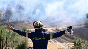
Strong northerly to northeasterly winds will continue today, reaching up to 8 Beaufort in the northern Cyclades, southern Evia, and eastern Attica. Combined with high temperatures and ongoing drought, these conditions will significantly increase the risk of wildfires.
Yesterday’s heatwave, which saw temperatures soar to 42°C in Skala, Messinia, especially affected western Greece. Similar temperatures are expected today, with a gradual cooling trend beginning on Wednesday.
According to the Fire Risk Prediction Map issued by the General Secretariat of Civil Protection (civilprotection.gov.gr), Tuesday, August 12, 2025, is expected to have a very high fire risk (Category 4) in multiple regions:
Very High Fire Danger – Category 4
- Attica Region (including Kythera)
- Peloponnese Region
- Western Greece Region
- Epirus Region (Preveza, Arta)
- Thessaly Region (SE Sporades)
- Central Greece Region (Fthiotida, Boeotia, Fokida, Evia including Skyros)
- Ionian Islands Region (Lefkada, Kefalonia, Ithaca, Zakynthos)
- Eastern Macedonia & Thrace Region (SE Thassos, SE Rodopi, SE Evros including Samothrace)
- Central Macedonia Region (Halkidiki, including Mount Athos)
- Northern Aegean Region (Lesvos, Lemnos, Chios)
The General Secretariat of Civil Protection has alerted all relevant government agencies, regional authorities, and municipalities in these areas to remain on heightened preparedness for rapid wildfire response.
Citizen Advisory:
Authorities urge residents and visitors to avoid any outdoor activities that could cause accidental fires, such as:
- Burning dry grass, branches, or debris
- Using spark-producing tools like welding equipment or circular saws
- Outdoor barbecues
- Beekeeping with smoke production
- Discarding lit cigarettes
During fire season, burning fields is strictly prohibited.
If you spot a fire, call the Fire Service immediately at 199.
For fire safety guidelines, visit: civilprotection.gov.gr.
Yesterday’s Heat Records
On Monday, August 11, the Peloponnese recorded the nation’s highest temperature — 42.0°C in Skala, Messinia — according to the National Observatory of Athens / meteo.gr. Close behind were Pinios Elias Dam and Oleni in Ilia at 41.3°C.
Data from 550 active weather stations showed:
- 242 stations (44%) exceeded 35°C
- 122 stations (22%) exceeded 37°C
- 17 stations exceeded 40°C
Today’s Weather Forecast – Tuesday, August 12
Mostly sunny across the country, with a few afternoon clouds in mountainous areas. Slightly higher dust levels are expected in Crete and the Dodecanese.
Temperatures:
- Western Macedonia: 18–33°C
- Rest of Macedonia & Thrace: 21–37°C
- Thessaly: 22–37°C
- Epirus: 24–40°C
- Western Central Greece: 23–39°C
- Rest of Central Greece & Peloponnese: 24–38°C
- Ionian Islands: 24–38°C
- North & East Aegean Islands: 24–38°C
- Cyclades & Dodecanese: 20–35°C
- Crete: 19–33°C
Winds:
- Aegean: NW to N, 4–6 Beaufort; locally up to 8 Beaufort in some areas
- Dodecanese: Variable, 2–4 Beaufort
- Ionian: N to E, 3–5 Beaufort; south of Zakynthos, winds shifting from north to west by midday, then to south by evening
Local Forecasts:
- Athens: Sunny, N winds 3–5 Beaufort, 25–35°C
- Thessaloniki: Sunny, light winds, 28–36°C
Outlook:
Wednesday, August 13 – Mostly clear, with local clouds in eastern mainland and northern Crete. NE winds 5–7 Beaufort, locally 8 Beaufort in the Aegean. Slight temperature drop.
Thursday, August 14 – Clear skies with a few clouds in central and southern areas. N winds 4–6 Beaufort, locally 7 in the Aegean. Further temperature drop.
Friday, August 15 – Clear with some clouds in the northwest. N winds 4–6 Beaufort, locally 7 in the Aegean. Slight cooling in eastern areas.
Saturday, August 16 – Mostly clear with occasional clouds in the north. N winds 5–7 Beaufort, possibly 8 in parts of the Aegean. Temperatures stable.
Ask me anything
Explore related questions


