
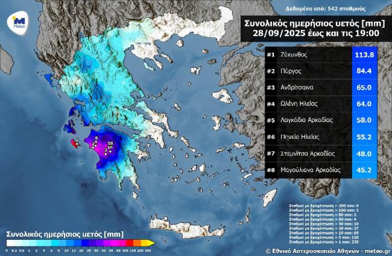
The first autumn storm system unfolded without significant issues. As meteorologist Giorgos Tsatrafyllias explained in a post, the system moved slowly and most of the phenomena remained offshore in the Ionian Sea. However, he noted that in the past 12 hours, nearly 50 tons of water fell over the central Ionian and western Peloponnese. According to Meteo.gr, the highest rainfall yesterday up to 19:00 local time was recorded in Zakynthos with 113.8 mm.
Tsatrafyllias also commented on the missed forecasts of widespread flooding, writing: “We’ve reached the point of complaining that there were no floods today even though the 112 alert was issued. For the record, more than 110 tons of water per stremma have fallen in Ilia and over 100 tons in Zakynthos.”
In the same vein, meteorologist Thodoris Kolyda reported 118 mm of rainfall already recorded by 19:00 Sunday at Zakynthos’ weather station and pointed to a new disturbance expected from Thursday.
Meteorologist Nikos Kanteres also issued a warning for heavy rain and local storms from Thursday, adding on Facebook: “And more to come. Temperatures will remain relatively low, so appropriate clothing and an umbrella are essential.”
Τα 118 mm βροχής σημειώθηκαν ήδη μέχρι και τις 19:00 της Κυριακής στο μετεωρολογικό Σταθμό της Ζακύνθου του @meteogr .
— Theodoros Kolydas (@KolydasT) September 28, 2025
Τα ίδια περίπου ύψη βροχής καταγράφονται και από τον δορυφόρο της JAXA .
Περισσότερα στο κεντρικό Δελτίο Ειδήσεων του @Starchannelnew1 με τον @spyroslamprou1… pic.twitter.com/1JoO9hz7k8
Today’s Weather
Meteorologists say the main front of the storm system will affect the Aegean, with storms expected through midday across the Cyclades, eastern Aegean, and Dodecanese before weakening. Temperatures will remain low.
- Monday: Rain will shift toward the Cyclades and southwestern Crete, later reaching the northern Dodecanese.
- Tuesday–Wednesday: Occasional showers in the northwestern Aegean, eastern Thessaly, and eastern Peloponnese.
- From Wednesday night into Thursday: A new low-pressure system from the west will bring renewed intense weather to western Greece (per Sakis Arnaoutoglou).
Heavy rainfall in the west – Sunday, Sept. 28
On Sunday, Sept. 28, heavy rains and localized storms mainly affected western mainland Greece and the Ionian.
According to the National Observatory of Athens / Meteo.gr’s network of automatic stations, significant rainfall totals were recorded in western Peloponnese and the Ionian islands. Zakynthos topped the list with 113.8 mm by 19:00 local time.
Detailed Forecast
Today (Monday)
- Clouds with local showers or storms in central and southern regions (Thessaly, Central Greece, Peloponnese, Ionian, Evia, Sporades, possibly Cyclades, Crete, and eastern Aegean islands).
- Elsewhere, chances of local showers mainly inland.
- Temperatures: 11–22°C north (7–20°C in western Macedonia), 14–24°C central & south, 13–24°C west (up to 26°C SW Peloponnese), 17–25°C Cyclades/Crete, 18–25°C eastern Aegean/Dodecanese.
- Winds: light, variable; Aegean up to 4 Beaufort, Ionian light E shifting to NW, nearly moderate.
Athens: Clouds, local showers in morning, 17–24°C, light winds.
Thessaloniki: Partly cloudy, 15–21°C, light winds.
Tuesday, Sept. 30
- Clear in Cyclades & Dodecanese.
- Elsewhere partly cloudy, thicker in north/east mainland & Crete with possible light rain.
- Morning/evening fog inland.
- N winds 3–4 Beaufort (SE Aegean 4–6).
- Temps stable, 23–25°C generally, up to 26°C Crete/Dodecanese.
Wednesday, Oct. 1
- Clear in Dodecanese.
- West: clouds increasing, rain in Ionian, chance of storms late.
- Elsewhere, clouds thicker in north/east mainland with showers or isolated storms.
- N winds 2–6 Beaufort depending on area.
- Temps steady.
Thursday, Oct. 2
- West & north: clouds, rain, scattered storms (locally intense in Ionian & mainland).
- Weather worsens across most of the country except SE Aegean.
- S winds west (4–6 Bf); N winds east, later shifting S/SE.
- Slight temperature drop NW.
Friday, Oct. 3
- Widespread rain and scattered storms (possibly strong in eastern areas).
- S winds 4–6 Bf, seas up to 7; later NW winds in west/north.
- Slight temperature drop west & north.
Ask me anything
Explore related questions


