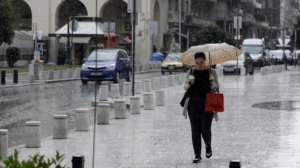
A new wave of bad weather is expected over the next five days, bringing rain and thunderstorms to many parts of Greece, according to meteorologists who warn of particularly intense phenomena mainly in western regions.
According to meteorologist Thodoris Kolydas, “two low-pressure systems will affect us in the coming days, with the heaviest rainfall expected mainly in western Greece.” In his forecast, the Star meteorologist explains:
“The first system (map 1) is moving slowly east-northeast and is expected to mainly affect northwestern Greece on Friday (map 2) with intense phenomena and locally gale-force southerly winds of 7–8 Beaufort in the Ionian. The second system (map 3) is coming from the Gulf of Sirte and will begin to organize on Sunday. These types of systems require close monitoring, as their movement is highly uncertain and they can also produce heavy rainfall.”
Meanwhile, Giorgos Tsatrafilias predicts “a significant water yield for western Greece over the next five days.” The Alpha meteorologist writes:
“Two disturbances from the west will affect us over the next five days, with considerable rainfall primarily in western Greece, and to a lesser extent in central mainland Greece, the Peloponnese, and possibly southern Thessaly.
– The first disturbance will affect us from early Friday to midday Saturday, and the second from midday Sunday to Monday night.
– In other regions, rainfall does not appear to be significant for now.
– Winds, except on Friday in the Ionian where they’ll reach 8 Beaufort (southerly), will not cause problems.
– Temperature will not change significantly.”
Nikos Kanteres also wrote:
“Rain is coming—and then the ‘Saint Demetrios summer’ (a traditional warm spell at the end of October).”
He notes:
“After the notable rains recorded in the first days of the month from two atmospheric disturbances, we had about a week of dry weather, except for a few showers in western Peloponnese. From tomorrow, Thursday (Oct. 16), and especially Friday, another disturbance from the central Mediterranean will bring rain to almost the entire country—except the southeast—and mainly to western Greece, where local storms, possibly strong, will occur.
On Saturday, phenomena will almost cease as the system moves away.
On Sunday, a second low-pressure system from the Libyan Sea will bring new rain and local thunderstorms, lasting through Monday and Tuesday and affecting the whole country. By Wednesday (Oct. 22), the weather will gradually improve.
The rain will be beneficial for farmland, forests, and groundwater.
Temperatures will remain around current levels, with cool nights and normal daytime highs.
From Thursday (Oct. 23) through the National Holiday (Oct. 28), sunny weather will prevail and temperatures will rise noticeably, bringing the traditional ‘Saint Demetrios summer.’
As October ends, more rain is expected, so the month won’t be as dry as last year.”
Today’s Weather
Clouds are expected over the Ionian, mainland Greece, and Crete, with local showers and possibly scattered thunderstorms in the west. The weather will begin to improve from the morning in Thrace and later in the afternoon in eastern mainland areas. Elsewhere, skies will be mostly clear with occasional clouds.
Temperature:
- Western Macedonia: 7–14°C
- Rest of Macedonia and Thrace: 11–21°C
- Thessaly: 12–19°C
- Epirus: 13–23°C
- Rest of mainland Greece: 11–22°C
- Ionian Islands: 14–21°C
- Aegean Islands: 12–22°C (up to 24–25°C in Crete and the Dodecanese)
Winds:
- West: southeast 4–6 Beaufort
- Aegean: northeast, and northwest in the southeastern Aegean, 3–5 Beaufort
Athens: Mostly cloudy, north winds 2–4 Beaufort, temperatures 12–23°C.
Thessaloniki: Mostly cloudy with local rain, variable winds 2–4 Beaufort, temperatures 12–19°C.
Friday, October 17 Forecast
Over the Ionian, western mainland, and gradually central and eastern Macedonia, Thessaly, and central Greece: cloudy weather with local showers. Scattered thunderstorms in the west, possibly intense in the Ionian. Elsewhere, a few clouds with a chance of light rain.
Winds: east-southeast 5–6 Beaufort, up to 7–8 in the Ionian (weakening later). East: east-northeast 3–5 Beaufort, later shifting southeast.
Temperature: little change.
Saturday, October 18 Forecast
Unsettled weather with intermittent clouds, local showers, and isolated thunderstorms in the Ionian, western, central, and northern mainland, and eastern Aegean islands. Gradual improvement in the west by afternoon. Elsewhere, partly cloudy with a slight chance of light rain.
Winds:
- West: west-northwest 3–5 Beaufort
- East: south-southwest 3–5 Beaufort, locally 6, turning northwest later
Temperature: slight rise, especially in central and southern areas.
Sunday, October 19 Forecast
Partly cloudy, increasing at times with local showers in northeastern mainland areas, northern and eastern Aegean islands, and later the Ionian and other mainland regions. Isolated evening thunderstorms in the Ionian.
Winds: east-northeast 3–5 Beaufort, northwest 4–5 Beaufort in the Dodecanese; strengthening southeast winds later in the Ionian.
Temperature: slight drop in the north.
Ask me anything
Explore related questions