
Intense weather phenomena will hit a large part of the country today, with rains, storms and locally hailstorms with western Greece already having faced problems from the change of weather.
In Vonitsa and Preveza several roads flooded with the traffic police intervening in several cases for pumping waters from underground and semi-underground spaces.
Video with the damages caused by the bad weather in Vonitsa


The new worsening of the weather is owed to the movement of a barometric low from South Italy towards Northern Greece, phenomenon which will cause extended rainfalls and locally strong storms from the west towards the east. The National Meteorological Service has issued emergency bulletin of worsening, warning for intense phenomena in many areas of the country.
Areas that will be affected
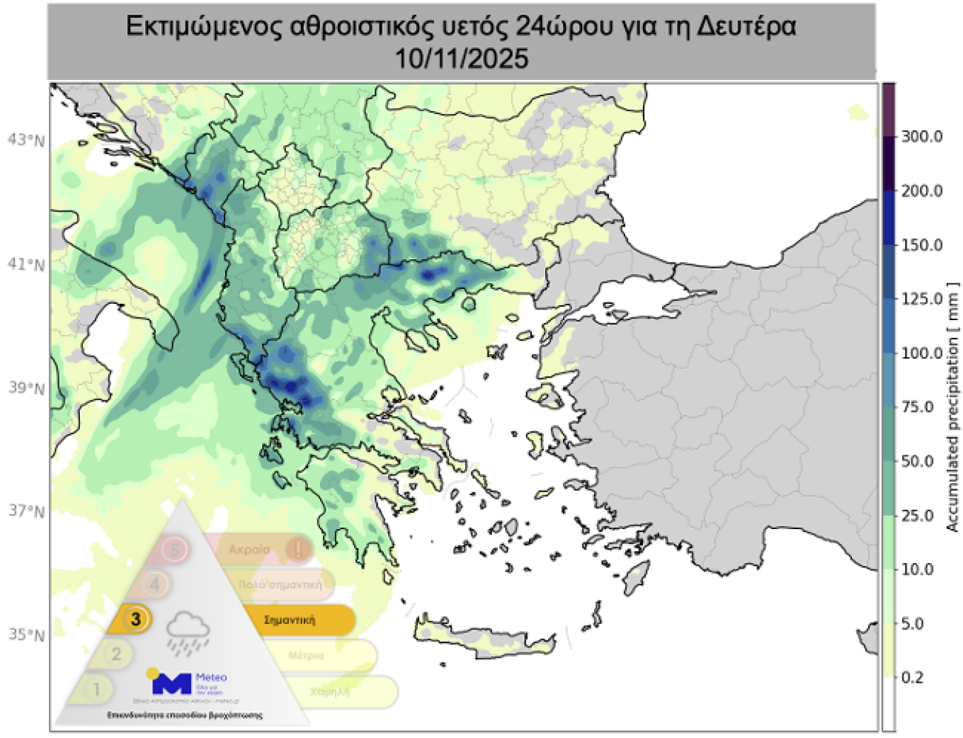
According to the updated emergency bulletin of worsening of the weather of EMY
Monday (10-11-25)
a. until noon in the Ionian, Epirus and western Sterea
b. until late afternoon in western Peloponnese
c. in central and eastern Macedonia
d. from the afternoon in Thrace.
On Tuesday (11-11-25) until noon in Thrace, the islands of the north-eastern Aegean and the Dodecanese
Significant rain heights and possible hailstorms
According to meteo.gr, rains and storms will occur in the largest part of the country, with exception the south-southeast island parts. The phenomena in areas such as Epirus, the Ionian, Western Greece, Eastern Macedonia and Thrace will be locally intense, accompanied by big heights of rain.
Additionally, there is increased possibility of hailstorms in areas of the Ionian, Western Greece, Peloponnese, Central and Eastern Macedonia, Thrace, as well as temporarily in Eastern Sterea and Attica. The rainfall episode is ranked in Category 3 (Significant), according to the Regional Precipitation Index of the National Observatory.
Warnings of meteorologists
The meteorologist Thodoris Kolydas draws attention for the next 24 hours in the areas that have already been designated by EMY in the west and north of the country. As he notes, “the new elements show big heights of rain in Corfu, Arta, Aetoloakarnania, the remaining islands of the Ionian and Laconia. From northern Greece attention is required in Prefecture of Kavala, Xanthi and Rodopi, mainly in the coastal areas”.
From his side, the meteorologist Giorgos Tsatrafyllias mentions that “from Monday night until Tuesday afternoon, rains and strong storms will occur in Thrace, the eastern island country and the Dodecanese”. He adds that “Monday noon locally intense phenomena will occur also in Attica, which will have small duration but remarkable intensity”.
Small drop of temperature
From Tuesday, the winds will turn to northern, causing small drop of temperature, while the phenomena will gradually weaken. The rains will be limited significantly during the week, with the weather presenting temporary improvement.
The weather today
Rains and storms are expected mainly in the Ionian, in the mainland and in the North Aegean. The rains and the storms locally in parts mainly of Epirus, Ionian, Western Greece, Eastern Macedonia and Thrace will be intense and will be accompanied by significant heights of rain. The storms locally in the Ionian, in Western Greece, in Peloponnese, in Central and Eastern Macedonia, in Thrace and possibly temporarily in Eastern Sterea and Attica will be strong and are likely to be accompanied by hailstorms.
Temperature will range in Western Macedonia from 7 to 17 Celsius degrees, in the rest Macedonia and in Thrace from 7 to 20-21 Celsius degrees, in Thessaly from 8 to 22-23 Celsius degrees, in Epirus from 7 to 19 Celsius degrees, in the rest mainland from 8 to 22-23 Celsius degrees, in the Ionian islands from 16 to 20 Celsius degrees and in the islands of the Aegean and Crete from 12 to 23-24 Celsius degrees.
In the Aegean the winds will blow from southern-southeastern general directions with intensities up to 4-5 Beaufort. In the Ionian will blow initially southeastern winds with intensities up to 5-6 Beaufort, while from the noon hours is expected turning of the winds to northwest with intensities up to 3-4 Beaufort.
In the prefecture of Attica clouds with local rains and storms are expected. The phenomena after the afternoon hours are likely to be locally strong. The winds will blow southern-southeastern with intensities up to 3-4 Beaufort. Temperature will range from 18 to 21 Celsius degrees.
In Thessaloniki rains and possibly storms are expected. The winds will blow from southeastern general directions with intensities up to 2-3 Beaufort. Temperature will range from 15 to 19-20 Celsius degrees.
The weather on Tuesday 11 November
In eastern Macedonia, Thrace, the islands of the eastern Aegean, the Dodecanese and temporarily in the Cyclades and Crete clouds with rains and sporadic storms. The phenomena until noon in Thrace, the islands of the north-eastern Aegean and the Dodecanese will be locally strong. In the rest country unstable weather periodically cloudy with local rains and temporarily mainly in western and central Macedonia isolated storms. Gradual improvement from the afternoon in all areas. The visibility in the morning and night hours will be locally limited mainly in the west.
The winds will blow western northwestern and in the eastern Aegean until noon from southern directions 4 to 5 Beaufort, temporarily in the seas locally up to 6 Beaufort.
Temperature will note small drop mainly in the north where it will reach 17 to 19, in the rest areas 20 to 23 and in Crete 24 Celsius degrees.
The weather on Wednesday 12 November
Few clouds locally increased in the eastern and southern country where local rains will occur and in Crete possibly isolated storms. The visibility in the morning hours will be locally limited.
The winds will blow from northern directions 3 to 5 Beaufort.
Temperature will note small further drop in all the country.
The weather on Thursday 13 November
In the eastern and southern country clouds with local rains, while isolated storms are expected initially in Crete and from the afternoon hours in the northern and central Aegean, where gradually they will intensify. In the rest country few clouds locally increased. The visibility in the morning hours will be locally limited.
The winds will blow from northern directions 3 to 5 and in the Aegean locally 6 gradually up to 7 Beaufort.
Temperature will note small further drop mainly in the east.
The weather on Friday 14 November
In the eastern and southern country, clouds with local rains and sporadic storms that in the night hours will be limited in the southernmost parts. In the rest country few clouds locally increased.
The winds will blow from northern directions in the west 3 to 5 and in the Aegean 6 to 7 possibly locally 8 Beaufort with gradual weakening.
Temperature will note small rise.
Ask me anything
Explore related questions